|
 |
A pdf version of this report is available
here
12.0MB
Click on CFS maps to view a high definition pdf image av.
1.4MB
Click here
to view high definition pdf images of all
maps 24.6MB
|
|
|
Coaxial Field Systems in
Swaledale
A
Reassessment
Timothy C. Laurie, Norman W. Mahaffy, and Robert
F. White.
Published by S P Eastmead SWAAG on 21st July 2010 |
Introduction
The archaeological wealth of Swaledale
became to be recognised in recent years, as a
consequence of the aerial photographs of Robert White of
the Yorkshire Dales National Park, and of the work of
the Swaledale Ancient Land Boundaries Project 1984-1993
(SWALB) directed by Andrew Fleming and Tim Laurie.
Andrew Fleming's book: 'Swaledale. Valley of the Wild
River' (Fleming 1998) has become the standard work on
the development of the landscape of Swaledale.
However, whereas ten detailed interim
SWALB Reports were issued, no final report was written
and the detailed conclusions of the ten year SWALB Project
were in a sense left hanging. The authors aimed to
address this and in the years following the work of
SWALB, further fieldwork has identified the very
numerous burnt mounds, interpreted here as sweat house
saunas and indicators of Bronze Age transhumant
settlement throughout Swaledale. Furthermore, this
fieldwork has identified key details of the field
systems which became clear following the annual
controlled burning by the Grouse Moor Estates of areas
of thick heather moorland.
This additional data has formed the basis
of this reassessment of the chronology of the wide
ranging high level 'coaxial' field systems
of Swaledale. Coaxial field systems so called, since
their main boundaries are parallel or coaxial. These
early field systems are so extensive
that they comprise an organised landscape which
required a collective design and managed construction.
These coaxial field systems
are located on open moorland between 300 and 430m OD and
exist in close juxtaposition
with evidence characteristic of Bronze Age settlement
activity elsewhere in Upland Britain,
namely:
areas with small
cairns, irregular stone walled enclosures, round house
settlements, the numerous burnt mounds, ring cairns and
round cairns (burial mounds) on open moorland above and
beyond the dry stone walled pastures which are such a
prominent feature of the landscape of Swaledale today.
We describe the key
relationship between the coaxial field systems and
these Bronze Age settlements and conclude that the
high field systems of Swaledale developed from Bronze Age settlement cores.
Large areas with settlement evidence remain
unsurveyed, especially areas of the lower dale
slopes within the present day walled pastures, see
figure 1. The recently formed Swaledale and
Arkengarthdale Archaeological Group (www.swaag.org)
is actively engaged in the mapping of settlements and
field systems of Late Iron Age and Romano British date
on the lower dale sides at Fremington and Healaugh.
In very few instances, we have been able to observe that
later settlement enclosures overlie the coaxial field
systems and that field boundaries associated with later
settlements abut but do not cross the earlier coaxial
field boundaries. These key relationships indicate that
the coaxial field boundaries were still recognisable features, perhaps as remnant hedges during the period of
Roman Occupation when settlements were established on
the lower dale slopes just above the Swale Flood Plain.
|
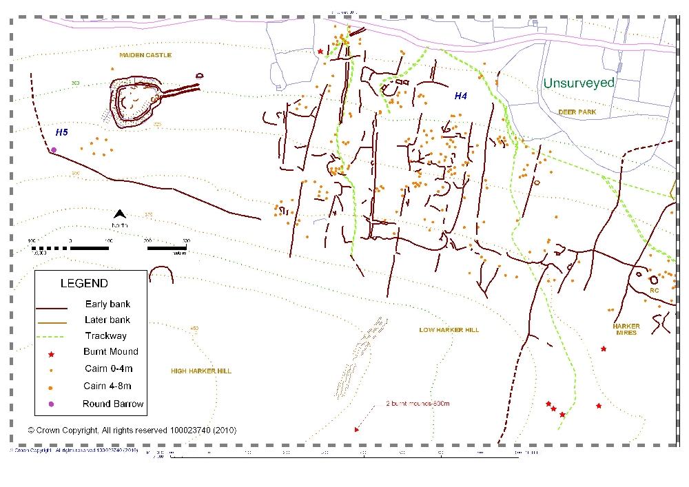
Notes on the maps and fieldwork.
This reassessment is confined to the coaxial
field systems on open heather moorland. With a few
exceptions, settlements within the present day enclosed
walled pastures have not yet been surveyed.
All the area
maps (except Figures 10, 11 and
12: Skelton Moor which are digitised versions of Laurie
1985, Figure 8.5) are digitised and updated
versions of surveys completed under the Swaledale Ancient
Land Boundaries Project (SWALB. Fleming and Laurie
1983-1994) and have of necessity been reproduced here at
small scale to accommodate the very large areas of the field
systems. Critical structural details of the field systems
are drawn at a larger scale on the Key Location Maps.
Key Location Maps are designed to show field
relationships that the coaxial field boundaries share with
structures of different periods in order to demonstrate the
relative chronology of the coaxial field systems.
The principal author, Tim Laurie, is
responsible for most of the field work and ideas in this
paper, building on his work with Andrew Fleming as part of
the Swaledale Ancient Land Boundaries Project which was
sponsored by the Yorkshire Dales National Park Authority. A
number of field surveyors were involved in the SWALB
Project, in particular Tom Gledhill, Ros Nichol, Tom
Godfrey, Par Connelid and Catherina Mascher. Our debt to
the project team is acknowledged. The continuation of this
field work, especially the development of a detailed
gazetteer of features for the YDNPA Historic Environment
Record (HER), and the preparation of this paper has been
encouraged and assisted by Robert White in his role as
Senior Conservation Archaeologist for the YDNPA. The
detailed maps are the work of Norman Mahaffy who has also
assisted in the post-SWALB fieldwork.
1 Coaxial Field
Systems in Swaledale - A Reassessment.
1.1
Summary
Beneath and beyond the limit, at around 300m
OD, of the present day dry-stone walled pastures of
Swaledale in the vicinity of Reeth, exists an earlier
organised landscape of fields with boundaries which share a
common, i.e. parallel, axis, see Figure 1. |
|
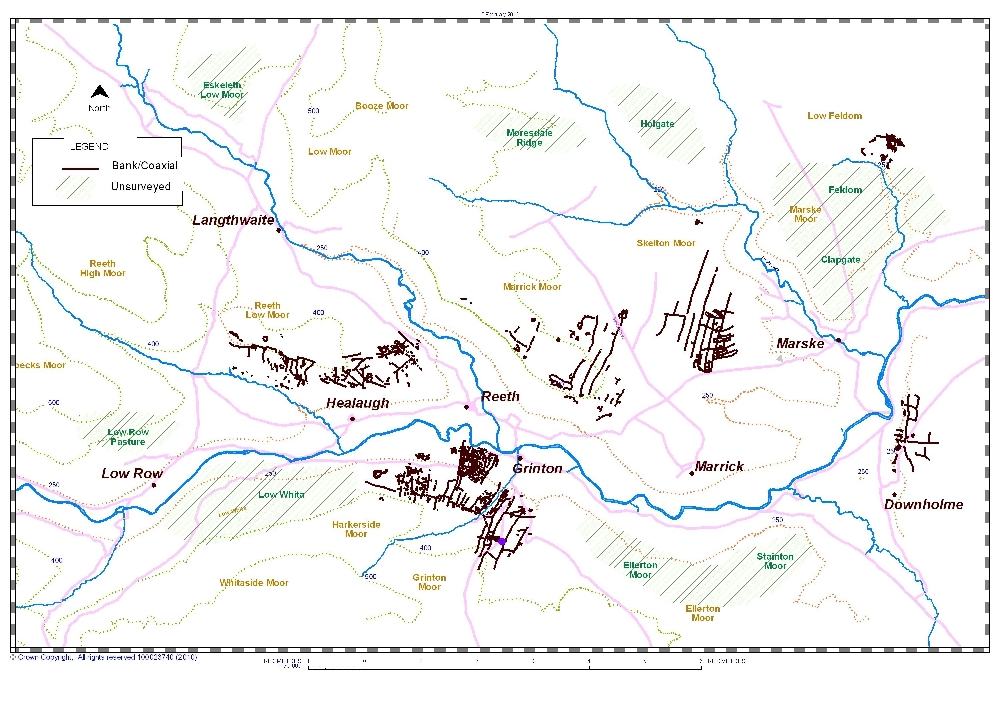
Figure
1: Swaledale. Coaxial field systems.
|
|
South of the River Swale, these field systems
sharing a NNE-SSW axis, reach altitudes of 410m at How Hill
on Grinton Moor and 380m on Harkerside Moor. North of the
Swale, on Reeth Low Moor coaxial field systems extend from
Fore Gill Gate eastward to the Arkengarthdale Road reaching
an upper limit at around 400m OD on the south facing slopes of
Cringley Hill and Calver Hill. The Marrick Moor coaxial
field system, also on a NNE-SSW axis, extends from
Fremington Edge at 420m OD across Copperthwaite and Raygill
Allotments reaching an unenclosed settlement in the pastures
at Lower Stelling east of the Hurst Road. Eastward from
Stelling Beck, in Marske Parish, the Skelton Moor Field
System crosses Forty Acres, Cleaburn Pasture and Cock How
Allotments on the same axis, reaching Moor House Gill and
Munn End on Skelton Moor above Telfit Bank (Photo 1). |
|
Photo
1: Reeth and Upper Swaledale from Reels Head
|
|
All these field systems have been described
previously (Laurie 1985, Fleming and Laurie 1984-1993,
Fleming 1998) but accompanying survey maps and analysis have
been selective. Subsequent fieldwork following heather
burning has revealed much detail, including the existence of
unenclosed settlements, numerous burnt mounds and other
critical structural associations, not previously noted. This
detail allows the development and relative chronology of the
field systems to be reassessed. The maps presented here use
all available sources including satellite imagery. YDNPA HER records based on aerial photography
show all these field systems, however critical relationships
can only be confirmed on the ground.
Although no final report on the SWALB Project
has been published, ten interim reports were issued to the
YDNPA who co-funded the project. In the absence of a final
report, the chronology of the field systems and the relative
chronology of the complex landscapes on the moors above
Reeth have been left hanging and a number of issues remain to
be addressed.
First, the coaxial fields were imposed upon a
landscape which had already been modified by Bronze Age
unenclosed cairnfield settlement activity.
The possibility had yet to be determined that the
coaxial field systems were associated, i.e.
had developed from, this Bronze Age settlement horizon so
widespread throughout Swaledale - as has been clearly
demonstrated for the coaxial field systems of the East Moors
of the Derbyshire Peak District (Barnatt, J. 1987).
Secondly, whereas it could be construed /
inferred that the very numerous platform settlements on the
lower dale sides were associated at least with the final
phases of development of the coaxial field systems of the
high moorland, no such direct association had been
demonstrated.
Thirdly, no discussion was available to
explain the motivation for the construction of the planned
landscapes which these coaxial field systems represent.
Neither has any attempt been made to ask who made them.
Work on the development of the detailed
gazetteer of features for the YDNPA Historic Environment
Record (HER) is well advanced and this work continues.
2 Previous archaeological
work on field systems in Swaledale, the nature of the
evidence.
The co-axial field systems and cairnfields on
open moorland in the vicinity of Reeth in Swaledale were
first introduced to a national audience by the writer at the
Newcastle conference, ‘Upland Settlement during the
Second Millennium BC and after’, and described in the
published proceedings (Laurie, in Spratt and Burgess 1985).
The coaxial field systems of Mid-Upper Swaledale,
although undated, were at that time considered to be
comparable in scale and morphology to those above
Grassington in Wharfedale (Raistrick 1935). By the
best of fortune Andrew Fleming, then Senior Lecturer at The
University of Sheffield, was at this time completing his
Dartmoor Reaves Project (Fleming 1988). Similarly,
Seamus Caulfield had surveyed and dated the extensive
sub-peat co-axial field systems at Belderg Beg, on the west
coast of Ireland in Co. Mayo to the Neolithic (Caulfield
1983).
Thus, in the early 1980s coaxial field
systems were beginning to be recognised and the problems
imposed by the very different chronologies and sometimes
complex development of these extensive early organised
landscapes throughout Britain were of considerable academic
interest. At the Upland Settlement conference, Andrew
Fleming proposed to the writer a project to complete the
reconnaissance and survey of the coaxial field systems in
Swaledale and to determine their chronology.
During the course of ten years fieldwork
between 1984 and 1993, the coaxial field systems on open
moorland generally above 300m OD on Reeth Low Moor, on
Marrick Moor, on Grinton Moor and on Harkerside Moor were
mapped by EDM theodolite at a scale of 1:2000. Limited
excavations on Reeth Low Moor indicated that the main Phase
2 coaxial field system here was constructed at around 300BC.
At a late stage in this work, the extensive zones of later,
Romano-British settlements within the walled pastures on the
lower dale sides was recognised and in part surveyed
(Fleming 1998, figs 1.5, 9.6 and 9.7).
The excavation of a single house platform,
one of a group of six similar platforms located within
a contemporary lynchetted field system on the steep
dale side east of Healaugh revealed four separate structural
phases, with evidence for occupation extending from the Late
Iron Age to the period of Roman occupation (Fleming 1998,
133-153).
SWALB surveys also included the outlying
cairnfield type settlement complex at the White Bog, on the
Stainton Moor army ranges (Fleming 1998, fig 8.3) surveyed
as an example of a single period cairnfield settlement of
Bronze Age character. The environmental history of the upper
dale slopes was examined through pollen analysis of a column
taken from deep peat within an overflow channel on Ellerton
Moor (Fleming 1988, 138-40).
Subsequent to the SWALB Project substantial
archaeological surveys of areas of high archaeological
interest on the Catterick and Feldom Ranges have been
commissioned by Defence Estates. These surveys cover the
recently recognised deserted medieval village and
prehistoric settlement at Low Feldom Farm, the settlements
and field system of late prehistoric character on Downholme
Moor and the defended settlement on How Hill, Downholme.
Fleming (1998) outlined the SWALB Project and
included maps and comments on selected aspects of the
coaxial field systems and dale side settlement so it will
not be described further here. However, the only
publication describing the early field systems of Swaledale
in total in context with the evidence further north on the
Tees / Greta Uplands including Stainmore remains the
introductory account following their initial recognition
(Laurie 1985). Fleming acknowledged the requirement
to ‘finish what we started’ (1998, 153) and it is hoped that
this reassessment will, together with the updated plans, in
some measure progress this.
The purpose here is the reassessment of the
coaxial field systems of Swaledale in the light of further
fieldwork and the placing on record the full extent of these
organised early landscapes as currently surveyed. Figure 1
shows the coaxial boundaries on open moorland, in the
vicinity of Reeth. Each area with coaxial fields is
separately described below. Areas with evidence of early
settlement in Swaledale which have not yet been surveyed are
also indicated on Figure 1; these further areas will be the
subject of targeted survey by the recently formed Swaledale
and Arkengarthdale Archaeological Group, SWAAG,
https://swaag.org/
affiliated to the Friends of the Swaledale Museum at Reeth.
Late prehistoric settlements within the lower enclosed
walled pastures are noted but detailed consideration of
these sites is beyond the scope of this article.
All areas with early field systems in
Swaledale show evidence for development over a very lengthy
period, that is to say they possess chronological depth.
This evidence can be stratigraphic,
where field
systems are abandoned and reconstructed across the same
ground but on a different axis, by lateral enlargement
where field systems are extended from earlier settlement cores and
elevationally
where following woodland
clearance, a field system is extended upslope or, downslope.
Following climatic deterioration and
podsolisation perhaps, the field systems on the high moors
were abandoned and settlement retreated downslope to occupy
the lower dale side walled pastures of today. Close
examination of the relationships that exist within the
boundary systems and of those of the boundaries and
pre-existing structures reveals complex development and
occupation over very long periods of time.
At the most elementary level of observation
the construction of the field boundary banks implies a very
lengthy period of use. The coaxial boundaries are low stone
banks which appear to be of dump construction (with
occasional revetting or facing stones) having accrued
through time by field clearance. Typically, the banks are
highly consolidated and of substantial dimensions. They
measure approximately 1m to 3m wide, averaging around 1.2m in width and
perhaps 0.75m in height on section. These boundaries are
interpreted as relict hedge banks which provided a real
barrier to contain and control stock. This interpretation is
supported by the fact that, where recognisable, gateways
are offset 3m to 4m for a length of 15m to provide a
lead-in for animals to the gate.
Within the coaxial field systems are found
examples of most of the features characteristic of
unenclosed Bronze Age cairnfield settlements throughout
upland Britain, for example see Barnatt 1987, namely
isolated large cairns, groups of small cairns,
burnt mounds, curvilinear enclosures, occasional lithic
scatters, irregular paddock like fields, cultivation
terraces, house platforms, round houses, ring cairns, cup
and cup and ring marked rocks, the last being limited in
distribution in Swaledale (Beckensall and Laurie 1998).
We had always recognised the presence of
these features but had concluded, instinctively rather than
on the evidence, that the coaxial field boundaries were
later constructs and intrusive to these Bronze Age
settlement complexes. Work on the escarpments of the East
Moors of Derbyshire, by Barnatt (1987) and more recently by
the Gardom’s Edge Project
(Internet link now unobtainable) has shown that settlement complexes dated
to the Bronze Age and very similar to those described here
are associated with contemporary coaxial field
systems. By analogy, the very high coaxial field
systems of Swaledale, in particular the Marrick Moor system
which is clearly associated with cairnfield type settlements could also have their origins in the
Second Millennium BC.
Interpretation of the association of the
coaxial field systems which range across the same ground as
these Bronze Age cairnfield and unenclosed settlement
complexes is only possible by careful survey. A single visit
to any of the high heather covered moorland areas of
Swaledale will not reveal the whole palimpsest of field
evidence. Over many years, the principal author, T C Laurie,
has noted features which are now invisible under thick
heather and continues to recognise features for the first
time when new areas of heather are burnt.
3 The Coaxial Field
Systems.
At least three
phases of settlement can be identified within the coaxial
field systems of Swaledale:
The earliest
of these is Phase 1, a ‘cairnfield settlement’ phase of
Bronze Age character. This early phase can perhaps be
regarded as seasonal, transhumant settlement which created
the original settlement cores from which the main Phase 2
unenclosed settlements with associated coaxial field systems
developed.
The Phase 2
settlements and coaxial fields are defined by very
substantial stone banks representing a very long period of
occupation. The development of the coaxial
field systems appears to have continued through many
centuries with the addition of settlement enclosures and
secondary coaxial fields subtended from the main coaxial
boundaries like ‘washing on a line’.
Late Phase 3
settlements and field systems comprise enclosed farmstead
settlements of late prehistoric and Roman date associated
with relatively slight coaxial field boundaries overlying or
abutting the main Phase 2 coaxials, as on Reeth Low
Moor at Riddings Rigg where a late field bank has clearly
quarried stone from the perimeter bank of an early Phase 1
circular enclosure (see Fleming 1998, fig 9.3).
Each area of
coaxial fields in Swaledale will be described in this
section with particular reference to the evidence for
chronological depth, noted at Key Locations.
3.1 Grinton Moor. References are to Figure 2.
3.1.1 Description
of Grinton Moor.
The coaxial field
system on Grinton Moor extends westward from Cogden Gill to Grinton
Gill and from the limit of the modern enclosed
pastures at 250m OD south of Grinton to ascend on to the
high moor plateau beyond How Hill, the escarpment formed by
the Main Limestone. The coaxial fields terminate at Ridley
Hush, at 410m OD, (photo 2). |
|
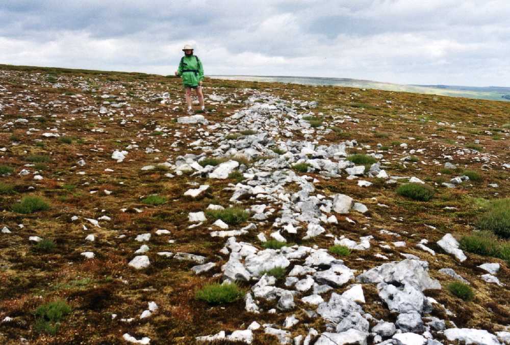
Photo 2:
Grinton Moor Ridley Hush
|
|
Six coaxial boundaries, form the framework to
the field system which shares the same SSW-NNE axis as the
large field systems across the Dale on Marrick Moor and on
Skelton Moor (see below). The Grinton Moor field system is
bounded by the steep ravines of Cogden Gill to the east and
Grinton Gill to the west. Each of the long coaxial fields
is further divided by occasional lateral banks.
The field system
appears to have been open ended with no convincing top dikes
to the field strips. The coaxials incorporate several stone
banked enclosures, G3-G7 on Figure 2, which, at differing
elevations, may be settlement cores although convincing
round houses and house platforms are not always visible. |
|
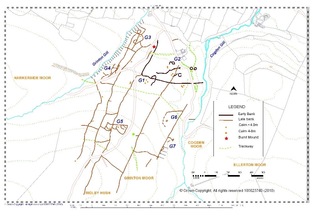
Figure
2. Grinton Moor, from Cogden Gill to Grinton Gill.
|
|
3.1.2 Chronology
of the Grinton Moor Coaxial Field System.
For Key
Locations, see Figure 2.
At Key location G1, a
coaxial field boundary abuts but does not cross a
pre-existing contouring field boundary which originates at Cogden Gill to turns down slope at
K1. This boundary
defines the limit of an open unenclosed settlement, cut by
the unfenced road south of Grinton Lodge, located at Key
Location G2. This settlement complex comprises four large
round house enclosures, small cairns, irregular field banks
and a single burnt mound at SE04559761, 275m OD, just 20m
east of the unfenced road to Redmire. (Photo 3). |
|
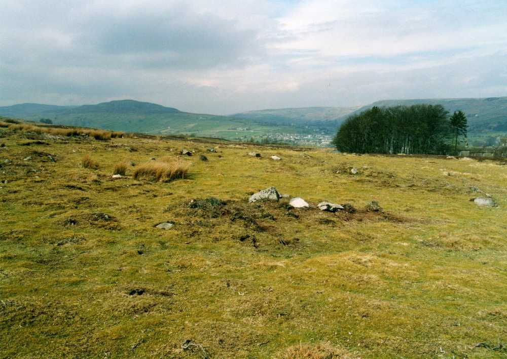
Photo 3:
Grinton Moor. Round house enclosure south of Grinton Lodge
Youth Hostel.
|
|
Two of the four round
house enclosures which average 20m diameter overall, 14m
diameter internally, were originally identified by the
author as ring cairns, but following the recognition of two
further enclosures masked under bracken and heather, the
enclosures are reinterpreted here as large round house
enclosures (for details of two excavated round house
settlements see Coggins and Fairless 1984; Gates 2009).
At key location G3,
the lowest at around 250m OD of several grouped enclosures
and possible settlements, G3-7, on Grinton Moor includes
strongly lynchetted boundaries implying possible reuse of
the field system for later cultivation here. The coaxials
and the grouped fields are centred on an ovoid embanked
enclosure which underlies a recent ruined sheep fold.
|
|
3.2 Harkerside Moor
References are to Figures 3, 4 and 5
3.2.1 Description of the Harkerside Coaxial
Field System.
These field systems extend westward for a distance of 2km
from Grinton Gill towards Maiden Castle. The whole of
Harkerside Moor, from Grinton Gill to Maiden Castle is
published here for the first time as Figure 3. For clarity,
details of the field system from Grinton Gill to the Deer
Park, Harkerside East, are shown at larger scale on Figure
4, and from Deer Park to Maiden Castle, Harkerside West, on
Figure 5. |
|
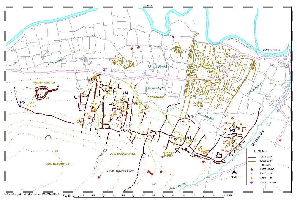
Figure
3. Harkerside Moor from Grinton Gill to Maiden Castle.
|
|
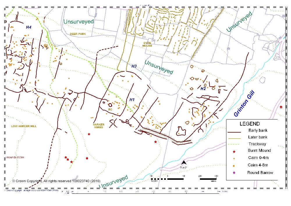
Figure
4. Harkerside East, from Grinton Gill to Deer Park
|
|
3.2.2 Harkerside Moor East.
The coaxials run at right angles to the slope from above the
present walled pastures at around 300m OD to reach an
elevation of 385m OD below High Harker Hill, (Photo 4 below). |
|
The
upper limit of this field system is defined by a top dike
bank which runs the full length of the base of High Harker
Hill. This boundary is aligned on the southern edge of the
prominent round barrow located 300m west of Maiden Castle. This upper limit of the fields extends eastward towards the
abrupt terminus of the linear earthwork at Harker Mires.
Subsequently, a number of coaxials were extended to include
additional areas of Low Harker Hill and Grovebeck Gill
which is enclosed by a single boundary crossing Grovebeck
at SE02909695. |
|
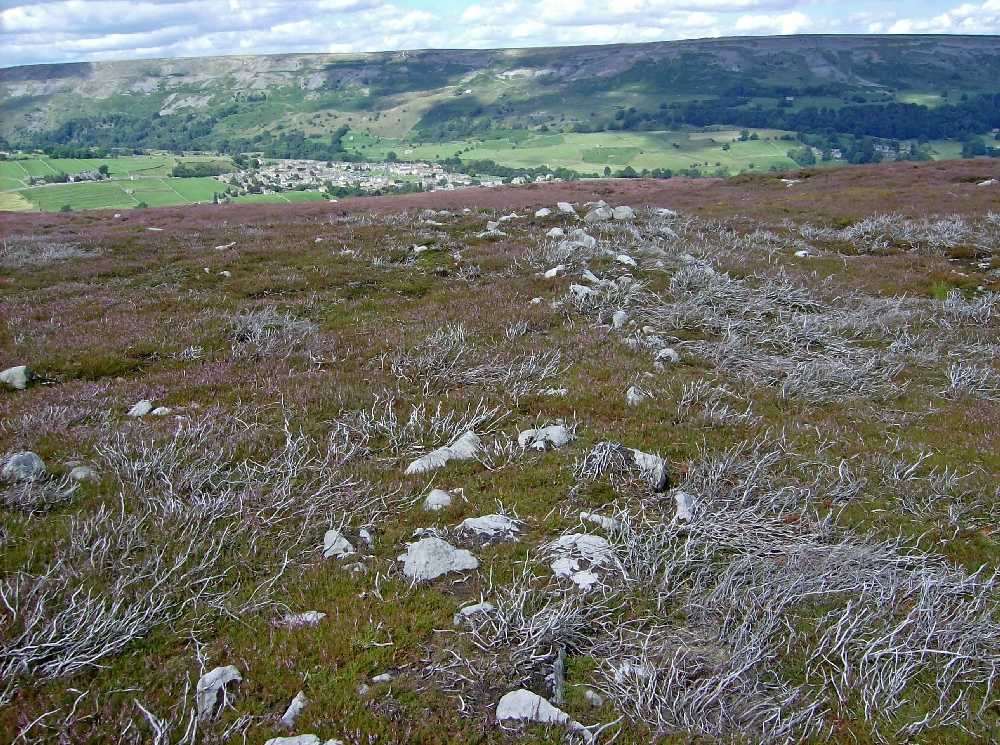
Photo 4: Harkerside Moor East coaxial.
|
|
The Harkerside Moor East coaxial field system crosses rising
moorland which everywhere shows extensive evidence for
Bronze Age cairnfield settlement including very large
numbers of clearance cairns, occasional ring cairns, and ten
burnt mounds. This early settlement evidence is most
concentrated at Harker Mires, Key Location H1, see below.
Cairnfield settlement evidence is not confined to the
highest levels of Swaledale but extends down into the
present day pastures of Harkerside where small cairns,
irregular field banks, three burnt mounds, and the scheduled
round barrow below Swale Hall testify to Bronze Age activity
at lower elevations. Later, Romano-British and medieval
enclosed settlements and associated fields are however
restricted to the lower slopes below 300m OD.
Settlement associated with the coaxial field systems on
Harkerside Moor proved difficult to identify and my view now
is that the field system developed seamlessly from the
earlier Bronze Age cairnfield settlement phase and is not a
later intrusion on the cairnfield settlements as had been
assumed.
3.2.3
Chronology of the Harkerside Moor East Field System.
For Key Locations, see Figures 3, and
4.
Key location H1, Harker Mires. SE037975, centre, (Laurie
1985, fig 8.4). Here the coaxial field boundaries incorporate an
extensive cairnfield centred on the prominent embanked stone
circle or ring cairn at SE03539761, 340m OD which is shown as
a hut circle on the OS 1:25,000 Outdoor Leisure Map, (Photo
5). |
|
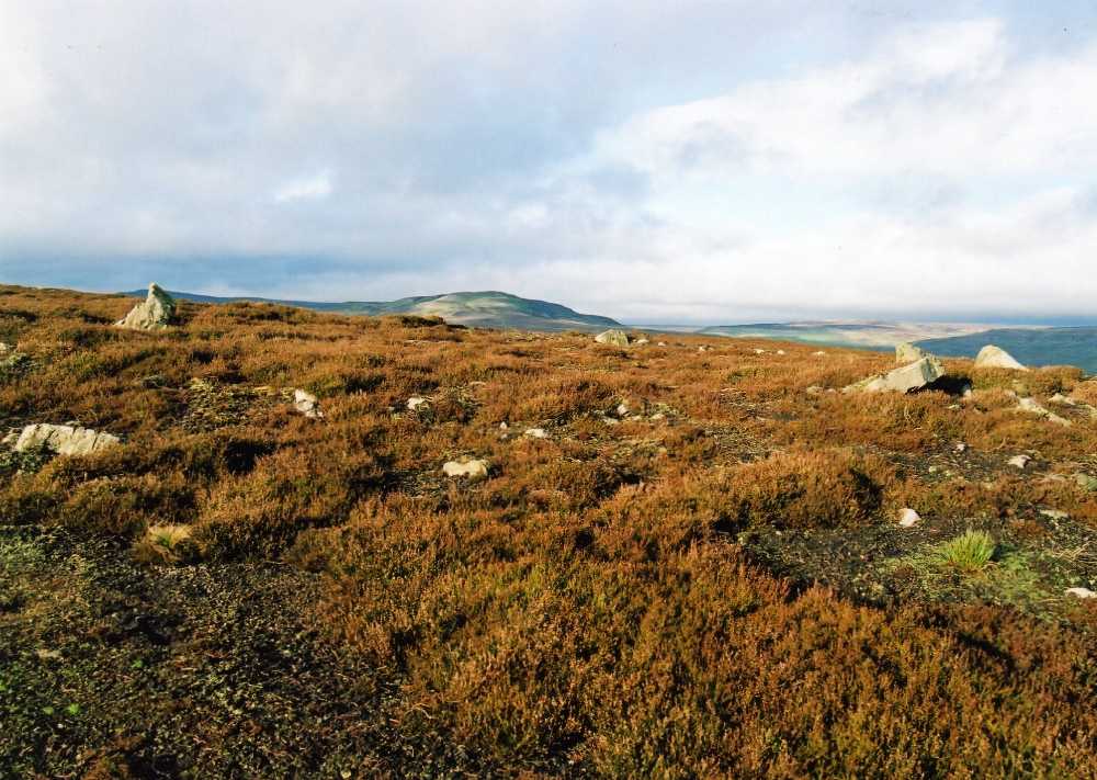
Photo 5:
Harkerside Moor. Ring cairn at Harker Mires.
|
|
At Key Location
H2,
SE043977, centre, a zone of settlement has been recognised
on the lower moorland slopes west of Grinton Gill. Here,
cultivation terraces, small fields, house platforms,
clearance cairns and a single rectangular building of some
20m in length with porched gable end entrance of early
medieval form all indicate a zone of intensive multi period
settlement. A coaxial boundary which descends from Harker
Mires is slighted by this later cultivation. Higher upslope,
north of the linear earthwork, two curvilinear enclosures
with several probable round houses may prove to be early
settlements contemporary with the cairnfield phase. A
further circular enclosure is located west of Grovebeck at
SE03549723.
At Key Location H3, at SE03569782 two later coaxial field
banks abut but do not cross the boundary defining the lower
limit of the Harkerside coaxial field system. These two
coaxials can be traced down into the walled pastures east of
the westernmost of the Grinton Fremington Dikes to the
settlement at Dike House Close, that slighted by the western
of the two Fremington Dikes on Harkerside considered to be
of Roman or medieval date (Fleming 1998, 21).
3.3 Harkerside West.
West of Deer Park, above Harkerside Place, the coaxial
field boundaries are on a slightly different alignment to
those of Harkerside East and are more closely spaced. These
coaxials may represent a late westward extension of the
Harkerside East field system towards Maiden Castle. This
area has been described previously. (Fleming 1998, fig 9.4).
3.3.1 Chronology of the Harkerside Moor West Field
System.
For Key Locations, see figures 3, and 5.
Key Location H4. Within the Harkerside West field system are very
significant numbers of small cairns and areas of irregular
field walling. These small cairnfields are evidence of early
cultivation and settlement activity on almost every small
terrace. It is possible that the Harkerside West coaxial field
system was associated with the settlement complex lower down
at Plaintree Farm, (Fleming 1998, fig. 9.6). |
|
Figure
5. Harkerside West from Deer Park to Maiden Castle.
|
|
A rare farmstead
settlement of early medieval type is located on moorland at
300m OD above Harkerside Place at SE02859812. This late
settlement consists of three rectangular buildings with
gable entrances within an enclosing yard like the excavated
settlements at Ribblehead (King 1978) and at Simey Folds (Coggins
and Fairless, 1986).
Key Location H5. The boundary marking the upper limit of
the Harkerside Moor field system below High Harker Hill at
340m OD extends westward to enclose the prominent oval
barrow located some 200m west of the earthwork enclosure of
Maiden Castle normally interpreted as an enhanced status
platform settlement of Late Bronze Age or Iron Age date
(Bowden and Blood 2004) although Vyner has noted
similarities to henge like enclosures and postulated a
Neolithic date (Vyner 2007). The western limit of the
Harkerside Moor field system is some 400m east of Maiden
Castle.
3.4 Two Unsurveyed Coaxial Field Systems.
The main location map, Figure 1 shows extensive areas
with recognised early settlement evidence as yet unsurveyed
in detail, (Photo 6). Space constraints do not allow full
description of these areas, however mention must be made
here of two isolated coaxial field systems west of Maiden
Castle which are directly associated with prehistoric
settlements. The first of these unsurveyed settlements is in
the juniper woodland just 1km west of Maiden Castle
(Para: 3.5). The second unsurveyed area is north of the
Swale in Melbecks parish (Para: 3.6). |
|
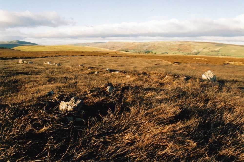
Photo 6:
Ellerton Moor. Field system aligned on small standing
stone. Three burnt mounds nearby.
|
|
3.5 Unenclosed Settlement and Coaxial Field System
east of Browna Gill, Low Whita. (Unsurveyed).
This settlement comprises a group of five round houses
centred at SE 01209820 located within and overgrown by
juniper scrub woodland. This settlement is linked by a
contouring field bank to a hill slope enclosure some 70m by
70m overall at SE01119816 with an entrance track leading
downslope towards the Swale and to a group of small fields
on the east side of Browna Gill. Two coaxial field
boundaries, associated with this settlement of Bronze Age
type (for details of excavated unenclosed settlements, see
Coggins and Fairless 1984; Gates 1983; 2009), rise upslope
from the east bank of Browna Gill to reach Blue Hill at
400m OD. The presence of a burnt mound at Blue Hill and
lithic finds at Browna Gill is further evidence for Bronze
Age activity here.
3.6 Coaxial Field System on Low Row Pasture and
platform settlement at Rowleth Wood.
Within the isolated stone walled intake at the NW corner
of Rowleth Wood, at SD96389805 is a settlement of six house
platforms with two adjacent conjoined scooped and banked
enclosures. A trackway leads upward from this settlement
towards Low Row Pasture, where a coaxial field system
crosses the calcareous grassland above the outcrops of the
Five Yard and Three Yard Limestones to the acidic moorland
over sandstone of Low Row Pasture below Stoops Rigg. This
field system seems to be associated with the Rowleth Wood
settlement. Within the field system on Low Row Pasture are a
few small cairns and remains of a heavily reduced round
cairn located at a viewpoint on a limestone pavement knoll
on the southern edge of the track above Barf Side. Lithic
scatters and a burnt mound at the spring head on Stoops Rigg
at SDSD96649858, 425m OD complete this interesting
settlement complex.
3.7 Reeth Low Moor - Calverside
References are to Figures 6 and 7.
3.7.1 Description.
Coaxial field systems of considerable complexity extend
across the south facing slopes of Calverside from Fore Gill
Gate to the Arkengarthdale road – a distance of 3.5km
crossing the south facing slopes of Cringley Hill, Calver,
Riddings Rigg and Black Hill.
See Figure 6. |
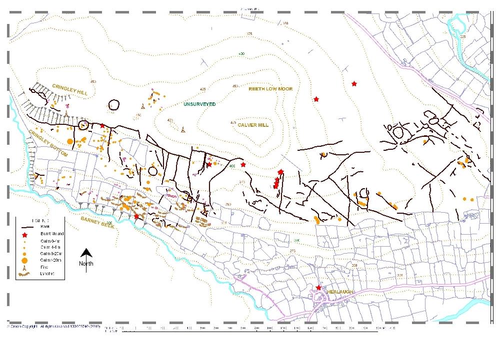
Figure 6. Reeth Low Moor
and Barney Beck Pastures.
See
Fleming 1998 Figure 9.7 for settlements within the walled
pastures East of Healaugh.
|
| The pre-coaxial
cairnfield settlement phase is well developed on and below
Cringley Hill (Figure 7). Areas with small cairns are
much less frequent east of Healaugh. At least two distinct
phases of coaxial field systems on Calverside have been
recognised, the lower terminating at 360m OD, the upper
extends across the entire south facing slopes of Cringley
Hill reaching 425m OD on Calver Hill. |
|
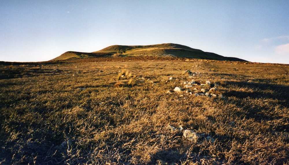
Photo 7:
Reeth Low Moor. Coaxial of the Reeth System on Riddings
Rigg.
|
|
The coaxial field
systems on the eastern slopes of Calverside, including those
on Riddings Rigg, (Photo 7) and on Black Hill and the late
prehistoric settlements within the pastures above and east
of Healaugh have been detailed and analysed previously,
(Fleming 1998, 133-153 and fig 1.5). Accordingly, this
discussion will be confined to the early settlement north
and west of Healaugh (see Figure 7, Calverside West) and to
the settlement complex within the present day pastures above
Barney Beck Woods at Low Cringley. The evidence on
Calverside West is detailed here for the first time.
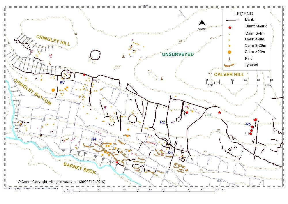
3.8 Reeth Low Moor - Calverside West. References are to Figure 7.
The upper coaxial field system on Calverside West is
defined by coaxial boundaries which cross the wide terrace
of Cringley Bottom and Cleasby from a boundary (the top
dike) which extends below the southern slope of Cringley
Hill at 400m OD and the higher slopes of Calver Hill where
it reaches 425m OD. This field system is associated with a
Bronze Age cairnfield settlement phase comprising very
numerous stone cairns generally distributed within the field
system but most concentrated on and below Cringley Hill and
around Cleasby on areas of deeper soils. Further monuments
predating the coaxial fields include a recently recognised
heavily quarried round cairn-like structure on Cringley
Bottom at SD99850023, several small ring banks interpreted
as ring cairns or settlements, lithic scatters and eight
burnt mounds. The three large circular embanked enclosures
shown on figure 7 may prove to be the local equivalent of
the Middle Bronze Age palisaded settlements so prevalent on
the Cheviot fringe (Jobey and Tait 1966). Further unenclosed
round house settlement complexes have been surveyed on the
northern slopes of Calver, for example those at NZ005006,
and on the south side of Hind Gill at NZ006012. |
|
Figure
7. Reeth Low Moor. Calverside West.
|
|
3.8.1 Chronology of
the Calverside West Coaxial Field System.
For Key Locations, see Figure 7.
Key Location R1: Settlements on and below Cringley Hill.
Here, a circular enclosure 60m diameter at NZ000004, 395m OD
containing several clearance cairns and two hut circles is
located at the limit of the field system which crosses
Cringley Bottom. The top boundary of the field system abuts
and respects this settlement enclosure. A burnt mound is
located some 50m to the east of the enclosure. At least one
of the numerous cairns on Cringley Bottom, appears to be
kerbed and is likely to be a burial monument. Two further
settlements located on Cringley Hill are shown on Figure 7,
the first of these is centred on an ovoid enclosure at
NY996006, 411m OD on the south facing upper slope of
Cringley Hill. Several other enclosures and two round houses
usually shrouded under heather, are located on this terrace.
Further field walling, clearance cairns and a small complex
ringwork associated with this settlement have been mapped
higher and to the east on Cringley Hill. An assemblage of
scrapers and a single broken barbed and tanged arrowhead
were found all together on the rutted track above this
settlement (see Laurie 2003, plate 40).
The large circular enclosure on Cringley Hill at
NZ002005, 422m OD, is defined by a substantial stone wall
1.2m thick. The stone core of this wall has been reduced by
quarrying but the earthfast basal facing stones are well
preserved and the bank was revetted by occasional orthostats.
This enclosure may be the local equivalent of the palisaded
settlements of the Cheviots, (Jobey and Tait 1966) although
no ring groove house structures are visible. Alternately,
this enclosure may be an embanked stone circle similar to
those of the Derbyshire Peak (Barnatt 1978).
At Key Location R2, a trench cut across a substantial
field boundary, at SE00749997, 385m OD, provided radiocarbon
dates from charcoal on both sides and below the bank to
around 300BC (Fleming 1998, 138).
Key Locations R3, R4 and R5: Settlements and field system
on the lower slopes of Calverside. At a later date, possibly following leaching and
podsolisation of soils, settlement appears to have retreated
downslope to more sheltered locations within the present day
walled pastures of Low Cringley Farm above Barney Beck, Key
Location R3. The settlement evidence here is very intensive,
see figure 7 and, allowing for variable survival within
cleared pastures, extends more or less continuously
eastwards from Low Cringley for the full length of
Calverside. An undated field system (the lower field system)
associated with this settlement reaches an upper limit at
360m OD visible intermittently on open moorland above Nova
Scotia, at Key Locations R4 above Thirns at Key Location R5
and further east above Riddings Farm where it forms the Late
Phase 3 (the Healaugh System) of Andrew Fleming’s analysis
of the field systems on Riddings, Calverside East (Fleming
1998, fig 9.3).
This later settlement phase is a zone of unenclosed
platform settlement with cultivation terraces and clearance
cairns which may well be contemporary with the numerous
house platform settlements and contemporary lynchetted field
system above and to the east of Healaugh dated to the Late
Iron Age and period of Roman occupation (Fleming 1998, fig
9.7) although no such association has been proved.
Excavation has shown the Healaugh field system to overlie
the earlier Phase 2 Reeth System (Fleming 1998, fig 9.2) and
at several locations the earlier boundaries of the Reeth
System are quarried out at the limit of the Healaugh system.
The upper field system on Calverside West may prove to be
contemporary with the early Phase 2 Reeth System. The lower
field system on Calverside West incorporates at least one
boundary of the earlier Reeth System. Further east, a Phase
1 circular enclosure on Riddings Rigg, is crossed and
slighted by a coaxial boundary of the Late Phase 3, Healaugh
field system, (Fleming 1998, fig 9.3; White 1997 fig 8).
3.9 Marrick Moor including Copperthwaite and Raygill
Allotments. References
are to Figures 8 and 9.
The coaxial field system on Marrick Moor is on the
preferred NNE / SSW alignment and extends from the escarpment
of the Main Limestone at Fremington Edge across
Copperthwaite and Raygill Allotments to reach the road from
Marrick to Hurst at Stelling and the walled pastures south
of Owlands Farm, an area of 3km2. This field system shares
the same NNE / SSW alignment with the main phase coaxial field
system on Skelton Moor, see Figure 8 to comprise a single
planned landscape covering 9km2 extending NE from Fremington
Edge for a distance of 3.5km to reach Moorhouse Gill and
Munn End above Telfit Farm in Marske Parish. |
|
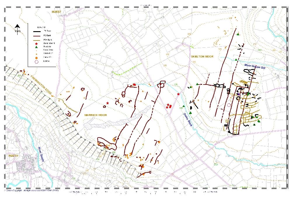
Figure 8. Marrick Moor and Skelton Moor. Coaxial field
systems.
|
|
3.9.1 Chronology of
the Marrick Moor Coaxial Field System. For Key Locations, see Figure 9.
The Marrick Moor field system can be shown to have
developed from curvilinear paddock-like stone banked
enclosures (M1-M5 on Figure 9) with occasional visible round
houses and groups of small cairns characteristic of Bronze
Age settlement elsewhere throughout Britain. This
association between the coaxials of the Marrick moor field
system and the unenclosed settlements is best seen at Key
Locations M1 and M4.
At Key Location M1, a coaxial boundary abuts but does
not cross the stone banked perimeter of a large elongated
curvilinear enclosure, some 450m OD by 150m overall, located at
420m OD in a most exposed situation on Fremington Edge. This
enclosure contains the visible remains of: a large round
cairn which is itself the focus of three field banks. Within
this enclosure are numbers of small cairns and possible
round house enclosures. |
|
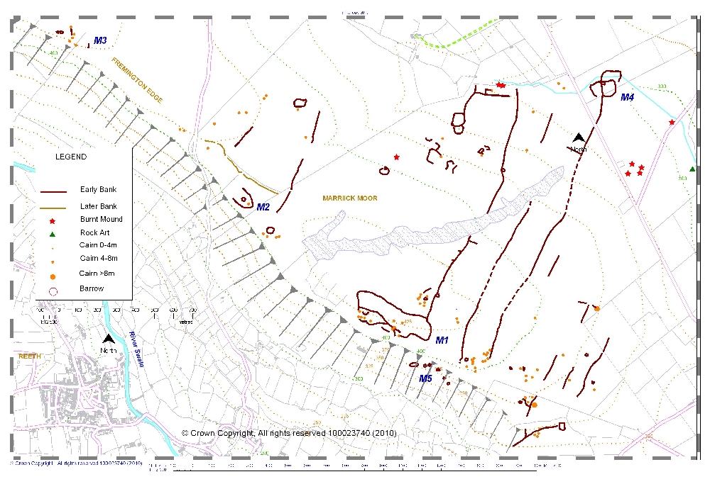
Figure
9. Marrick Moor. Fremington Edge, Copperthwaite Allotment
and Owlands Allotment. Bronze Age settlements, burnt mounds
and coaxial field system.
|
|
Two
further unenclosed settlement complexes, the Radio Mast Site
(M2) and Fremington West (M3) are also located at 400m OD on
Fremington Edge, the first of these is situated at the
remains of the old radio mast east of the track to Hurst,
above the White House, (Photo 8), the second was originally
located by aerial photography on the edge of the escarpment
above Castle Farm.
Strong springs rise further east lower down the dip slope
to form the focus for several circular enclosures, a group
of three burnt mounds south of Owlands Farm and one very
large isolated burnt mound on open moorland at NZ09330248.
|
|
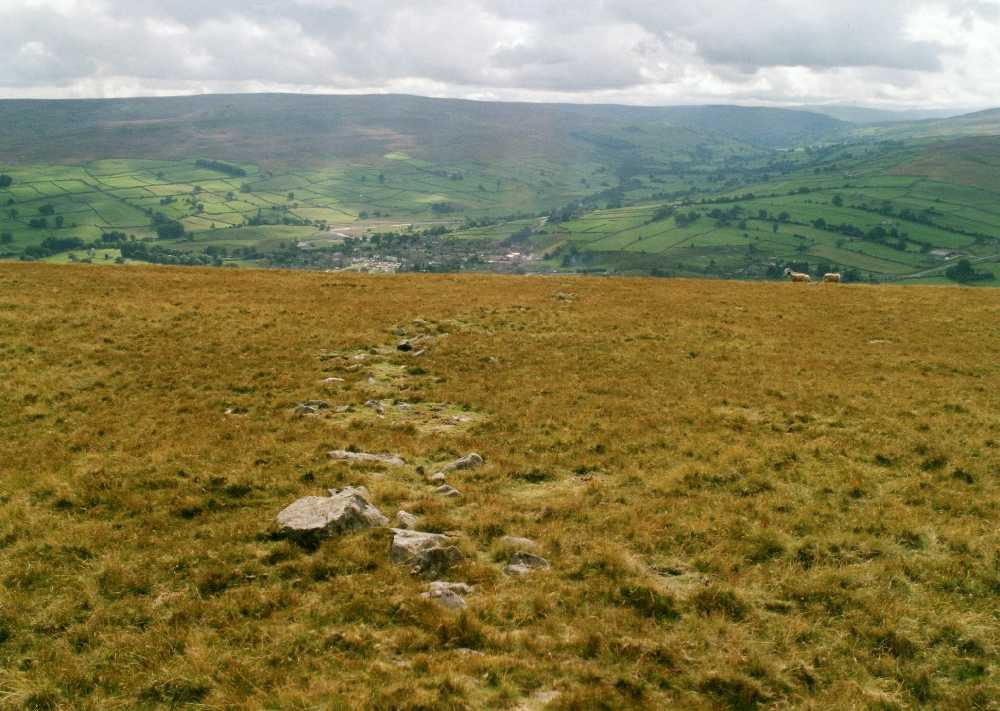
Photo 8:
Fremington Edge. Coaxial at the Radio mast Site.
|
|
Key Location M4, Fig.
9. Here, a field bank central to an unenclosed settlement
with two round houses and attached fields first identified
from aerial photographs, extends southward to Fremington
Edge as a long coaxial (Photo 9). This unenclosed
settlement at Stelling Bottom is very similar to the
excavated settlement at Bracken Rigg, Upper Teesdale dated
to 3180 +/- 60 bp (Coggins and Fairless 1984). The single
burnt mound located next to Dales Beck and the group of four
burnt mounds below the road at Stelling Springs are likely
to be associated with this settlement. Two cup and ring
marked rocks close to Dales Beck have been identified (Beckensall
and Laurie 1998, 96). The presence of two rocks with
inscribed crosses at NZ072008 on Forty Acres points to a
later association with Marrick Abbey. |
|
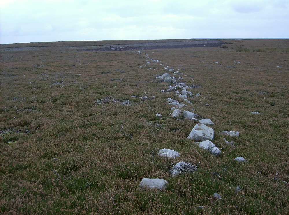
Photo 9:
Copperthwaite Allotment. Coaxial at 420m OD.
|
|
Key Location M5, Figure 9 (above). Recent fieldwork above West Hagg and Sorrel Sikes farms
has identified a significant settlement zone consisting of
two rows of house platforms located in bracken on natural
terraces between 300m OD and 380m OD below the highest scar
formed by the Main Limestone on Fremington Edge. A narrow
trackway leads from this settlement towards the field system
on the high moorland of Copperthwaite Allotment above. Lithic finds on Marrick Moor are generally of mesolithic
and early neolithic forms.
3.10
Marske. Skelton Moor
including Forty Acres, Cleaburn Pasture, Cock How and Moor
House Allotments.
(See
Figures 8, 10, 11 and 12, Aerial Photos 1 and 2) |
|
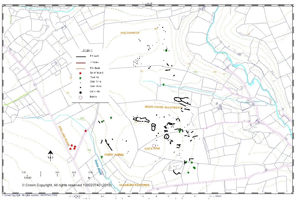
Figure
10. Marske. Skelton Moor including Forty Acres, Musgrove
or Cleaburn pasture,
Cock How and Moor House allotments.
Early Phase 1 cairnfield settlement.
|
| The
coaxial field systems on Marrick Moor and Skelton Moor share
the same axis and were recognised, surveyed and briefly
described during the early 1980s (Laurie 1985, figs 8.2,
8.5). The Skelton Moor field system described here extends
from Dales Beck across Forty Acres, Musgrove or Cleaburn
Pasture, Cock How and Moor House Allotments to reach Moor
House Gill and Munn End on Skelton Moor. Subsequent work and
satellite images have assisted an understanding of the
complex development and relative chronology of this
extensive field system. |
|
Figure
11. Marske. Skelton Moor including Forty Acres, Musgrove
or Cleaburn pasture,
Cock How and Moor House allotments. Main Phase 2 coaxial field system and later settlements.
|
|
3.10.1 Chronology of the Skelton Moor Coaxial Field
System. For Key Locations see Figures
10-12
In brief, the development of the coaxial field system on
Skelton Moor is similar to that on Marrick Moor with
characteristic evidence for an early, Phase 1 cairnfield
settlement phase, identified across the whole area see
Figure 10. This early phase, as elsewhere, comprises
curvilinear stone banked enclosures with occasional round
houses, groups of small clearance cairns, occasional large
round cairns, ring cairns and rock art sites. No burnt
mounds have been identified north of Dales Beck, however the
burnt mounds at the springs south of Dales Beck may have
related to unenclosed settlements at Forty Acres and on Cleaburn Pasture.
At Key Location K1, a 70m diameter Phase 1 circular
enclosure has been incorporated within the Phase 2 coaxial
field system indicating the continued occupation of this
significant feature.
At K2, a large oval stone banked enclosure is slighted by
later field clearance and by mining activity.
At K3, 4 and 5 grouped enclosures are crossed by later coaxials.
At K6 and 7 open settlements of house platforms have been
identified on the east side of Dales Beck and on the south
facing slopes of Cleaburn Pasture.
At K8 and 9 rectangular enclosures, possible settlements
are attached to coaxial boundaries. These enclosures are
associated with secondary field systems defined by long
field boundaries subtended from and linking the coaxials.
|
|
Figure
12. Marske. Cock How.
|
|
At K10 a bank and
ditched sub-rectangular enclosure with slightly bowed sides
overlies a Main Phase 2 coaxial boundary. Similar enclosures
elsewhere in lowland Britain have been found to contain
round houses of Iron Age or Roman date.
At K11 a D shaped
enclosure which probably enclosed at least one round house
is attached to a coaxial boundary. This enclosure is central
to a planned rectangular field system subtended from the
coaxial. |
|
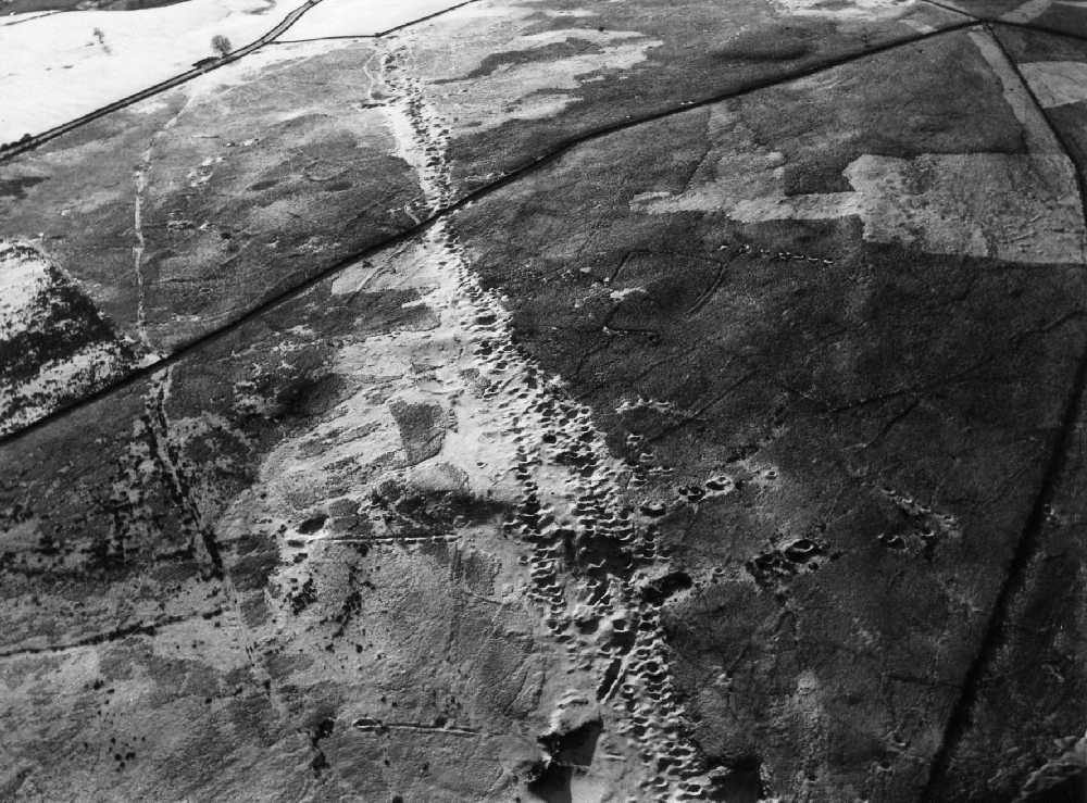
Aerial
Photo 1: Marske. Coaxial field system crossed by the
Cleaburn Pasture lead mining ground.
Kind permission NYCC
|
|
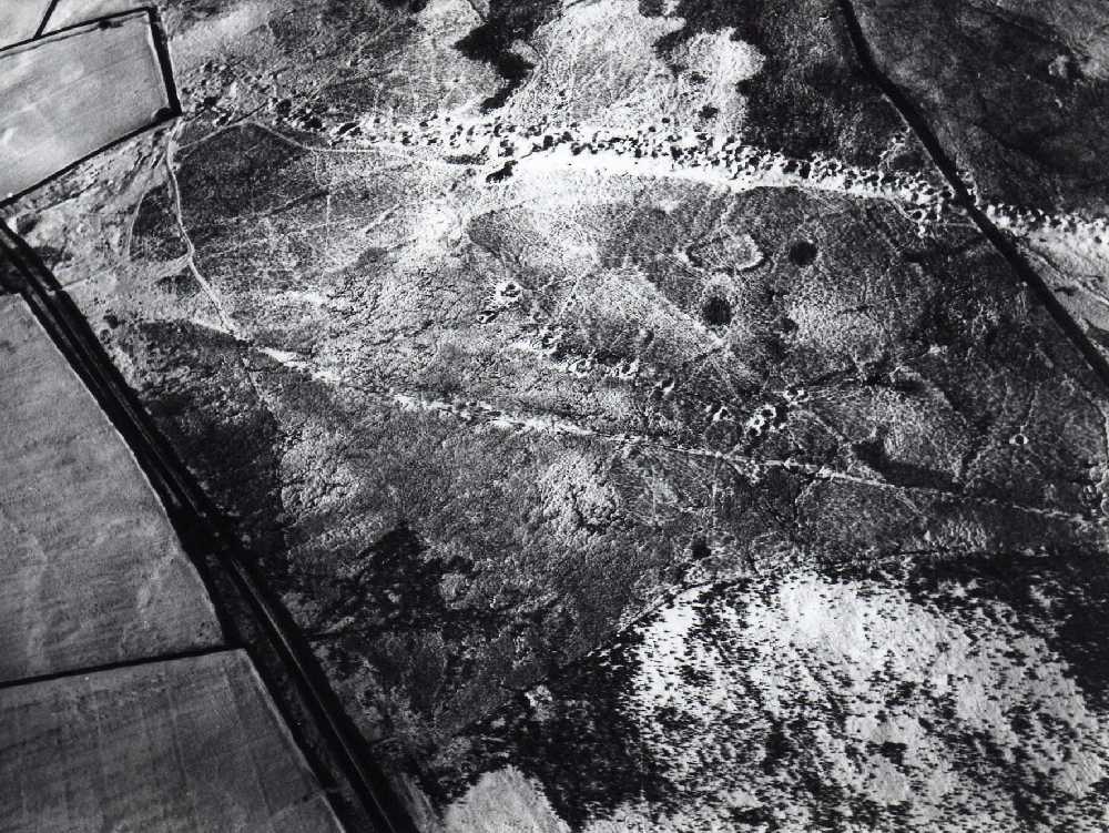
Aerial
Photo 2: Marske. Cleaburn Pasture. D-shaped enclosure and
field system subtended from coaxial.
Kind permission NYCC
|
|
4 Notes on the general distribution and context of
Rock Art and Burnt Mounds on the North East Pennine Fringe.
At the commencement of this article, see Section 2 above,
we have drawn attention to the fact that within the coaxial
field systems are found examples of most of the features
characteristic of unenclosed Bronze Age cairnfield
settlements throughout upland Britain, (Barnatt 1987), namely isolated large cairns, groups of small
cairns with numerous burnt mounds, curvilinear enclosures
and occasional lithic scatters, irregular paddock like
fields, cultivation terraces, house platforms, round houses,
ring cairns, cup and cup and ring marked rocks, the last
being limited in distribution in Swaledale (Beckensall and
Laurie 1998).
In view of this, and to clarify the relationship between
with the coaxial field systems which are the main subject of
this article and the Bronze Age cairnfield settlements which
together with the associated rock art sites and very
numerous burnt mounds provide the evidence for the origins
of the development of the organised landscapes of coaxial
field systems we provide below a note on the regional
context for these sites.
For the general distribution of these sites on the
Eastern Pennine Fringe, see Figure 13 (Rock Art) and Figure
14 (Burnt Mounds).
4.1 Rock Art.
The general distribution of rock art sites across the Ure,
Swale and Tees-Greta Uplands is not random. Rather the sites
are located on the edge of high ground overlooking the Tees,
Swale and Ure Lowlands, that is to say they overlook
Teesdale and the Vale of Mowbray. Herein, Laurie suggests,
lies the clue to their purpose. Some examples are shown in
photos 10-13.
The understanding of the context of rock art in Britain
can best be understood by relevance to the rock art of
indigenous people, both in the past and in the present. Two
examples will suffice to illustrate this. (4.1.1 and 4.1.2)
|
|
%20CCF28062010_00000.jpg)
Figure
13: Prehistoric sites between Rivers Swale and Tees
|
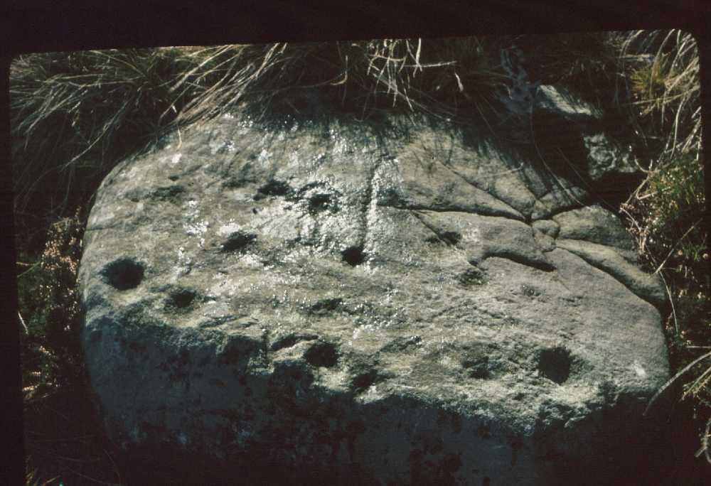
Photo 10 Cup marked rock. Munn End. Skelton Moor.
|
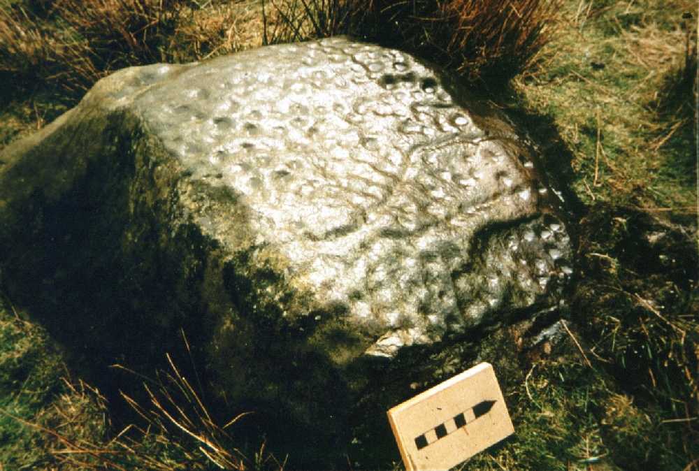
Photo 11 Cup marked rock. Pastures below Cock How (Private
land).
|
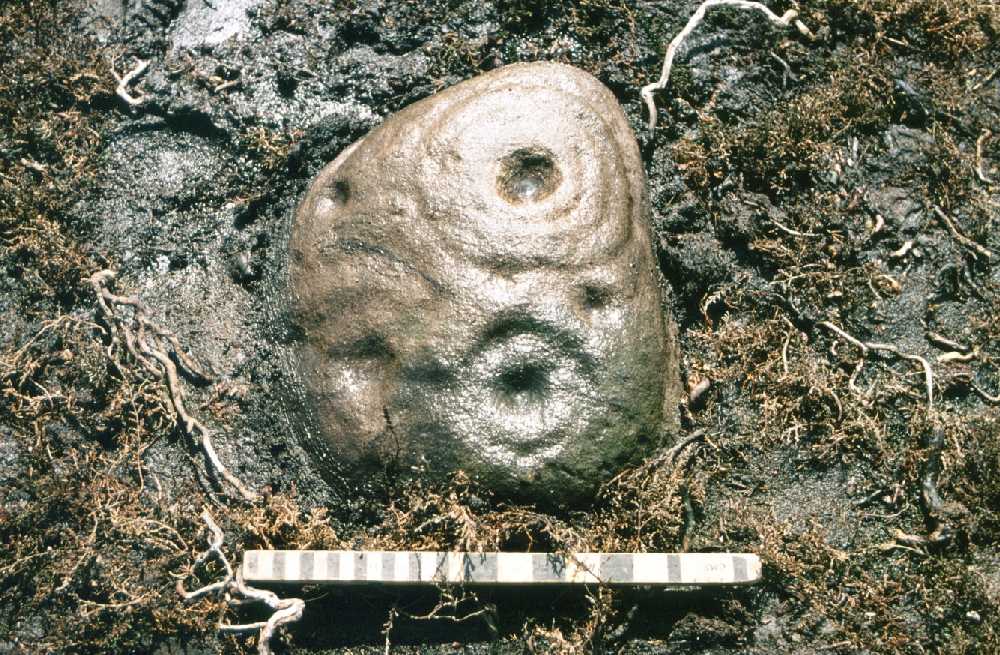
Photo 12 Cup and ring marked boulder, possibly
originally in one of the small cairns nearby.
|
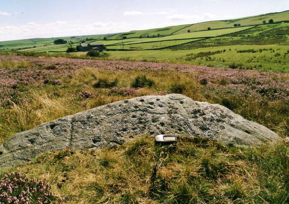
Photo 13 Cup marked rock. Forty Acres.
See Current Archaeology 241. April 2010, p9 for details
of the extraordinary decoration on this rock revealed
after removal of the turf covering.
|
|
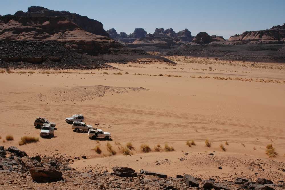
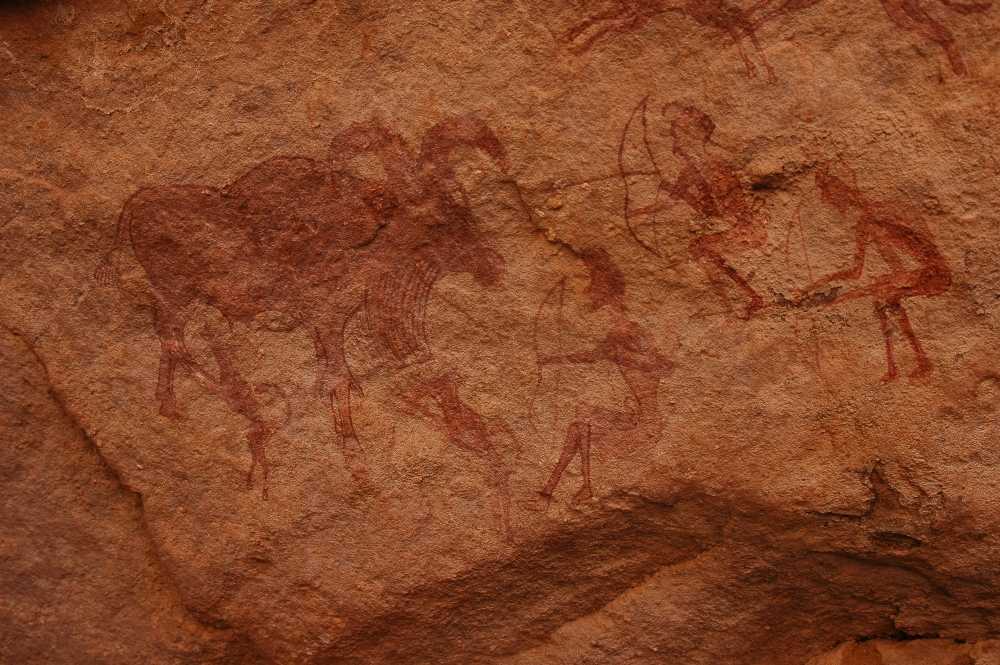
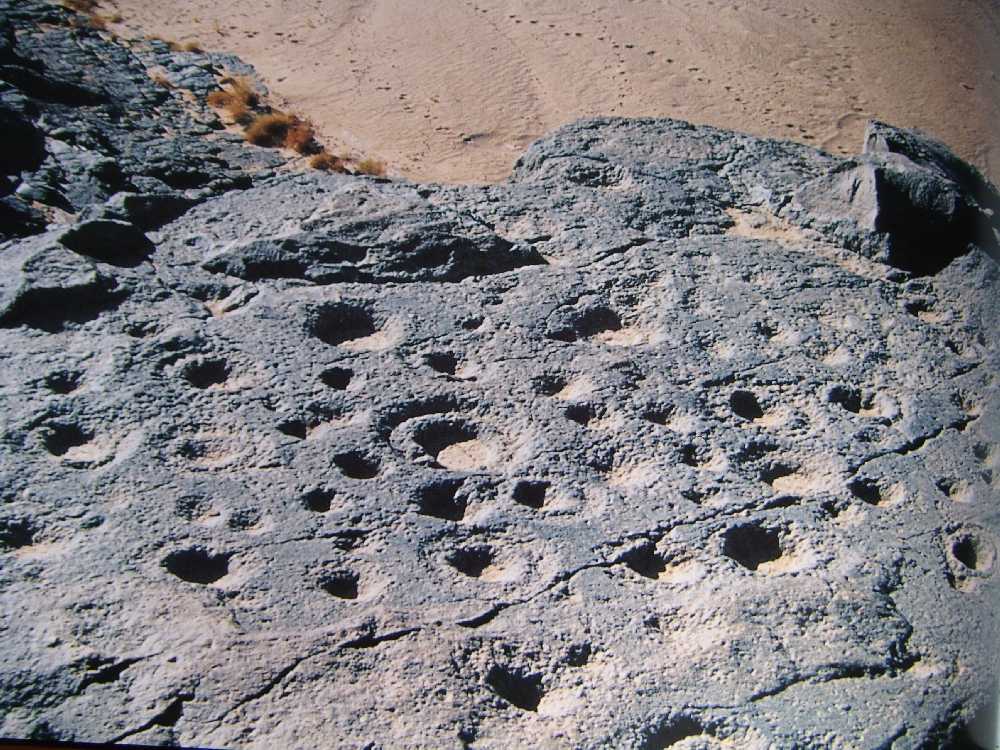
4.1.1 Rock art of the Libian Sahara. In the first instance, the painted rock art within the
Tadrart Acacus and the engraved rock art of the Messak
Plateau on the southern border of Libya near Ghat (Photo 14)
depicts scenes representative both of hunting (Photo 15) and
first domestication of the wild Barbary Sheep (The elusive
Mesolithic / Neolithic Transition) (Photos 14-21) in close
association with cup and ring marked rocks identical to
those on Gayles Moor, on Barningham Moor and elsewhere in
Northern Britain (Photo 10-13). The cup and ring marks of
the Acacus and Messak Wadis are located above and directly
in front of the same painted rock shelters (photo 17 and
18).
|
|
Photo
14: Libya; Tadrart Acacus; Wadi Teshuinat. View from Rock
Shelter
|
|
Photo
15: Libya; Tadrart Acacus; Wadi Teshuinat Uan Amil. Barbary
Sheep hunted
|
|
Photo
16: Libya; Tadrart Acacus; Uan Amil Mesolithic-Neolithic
transition. Man and domesticated Barbary sheep
|
|
Photo
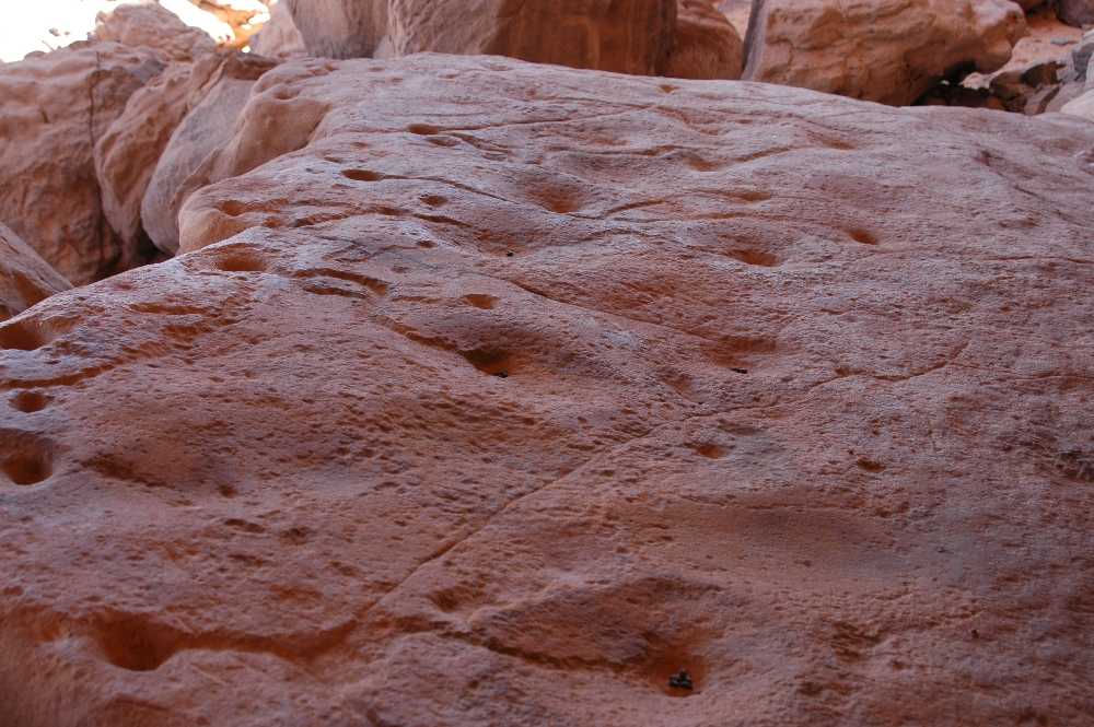
17: Libya; Tadrart Acacus; Uan Amil. Cup marked rock
|
|
Photo
18: Libya. Messak. Cup and Ring marked rock above
decorated rock Shelter.
Photo: Albada and Albada 2000, Figure 87
|
|
4.1.2 Alpes Maritimes, Vallee de Fontanalbe.
Secondly, a model for a context for the rock art on the
Pennine Fringe is provided by the annual transhumance to the
Vallee de Fontanalbe below Monte Bego when 600 head of white
cattle are led even today each year on the 20th June
to the rich pasturage of the Vallee de Fontanalbe by
transhumant herdsmen from the Plains of Lombardy (Photo 19)
to eat their way through the rich herbage of the open larch
woodland reaching an altitude of 2,200m at the upper limit
of woodland where several hundred decorated rock surfaces
show that this was also the limit of the territory visited
each year by transhumant herdsmen of the Late Neolithic
(photo 19 - 21).
|
|
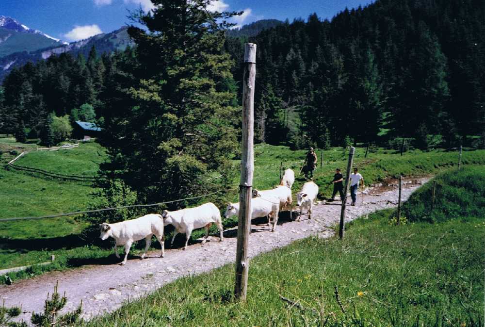
Photo 19: Alpes Maritimes, Vallee de Fontanalbe.
The
transhumance
|
|
Adopting this model, the rock art of the Pennine Fringe
can be regarded as being located at the limit of territories
visited each year by transhumant herdsmen from the Ure,
Swale and Tees Lowlands. Laurie considers that both rock art
and the very numerous burnt mounds are evidence for
transient, seasonal occupation by transhumant pastoral
family groups returning each year with their animals to
their ancestral pastures at the best grazing areas- at the
most constant springs, on the limestone terraces of Ure,
Swale and Tees-Greta Uplands. These small family groups,
possibly specialist herdsmen within a larger tribal group,
would mark their territory with rock art.
|
|
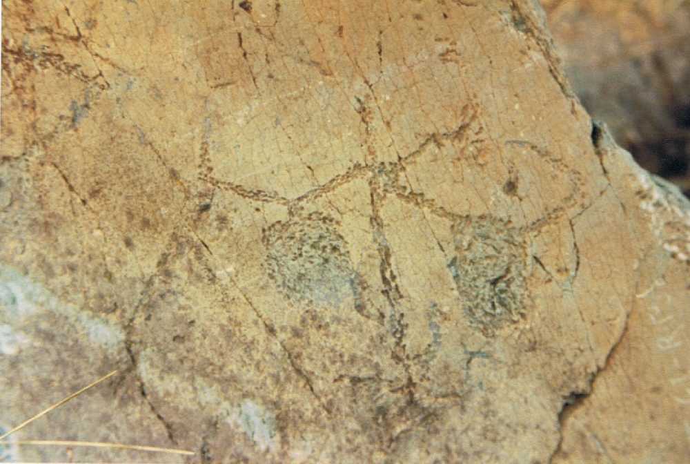
Photo 20: Alpes Maritimes. Monte Bego.
Oxen and
Plough scene.
|
|
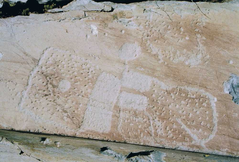
Photo 21: Alpes Maritimes. Monte Bego.
Fields
and settlement carving
|
|
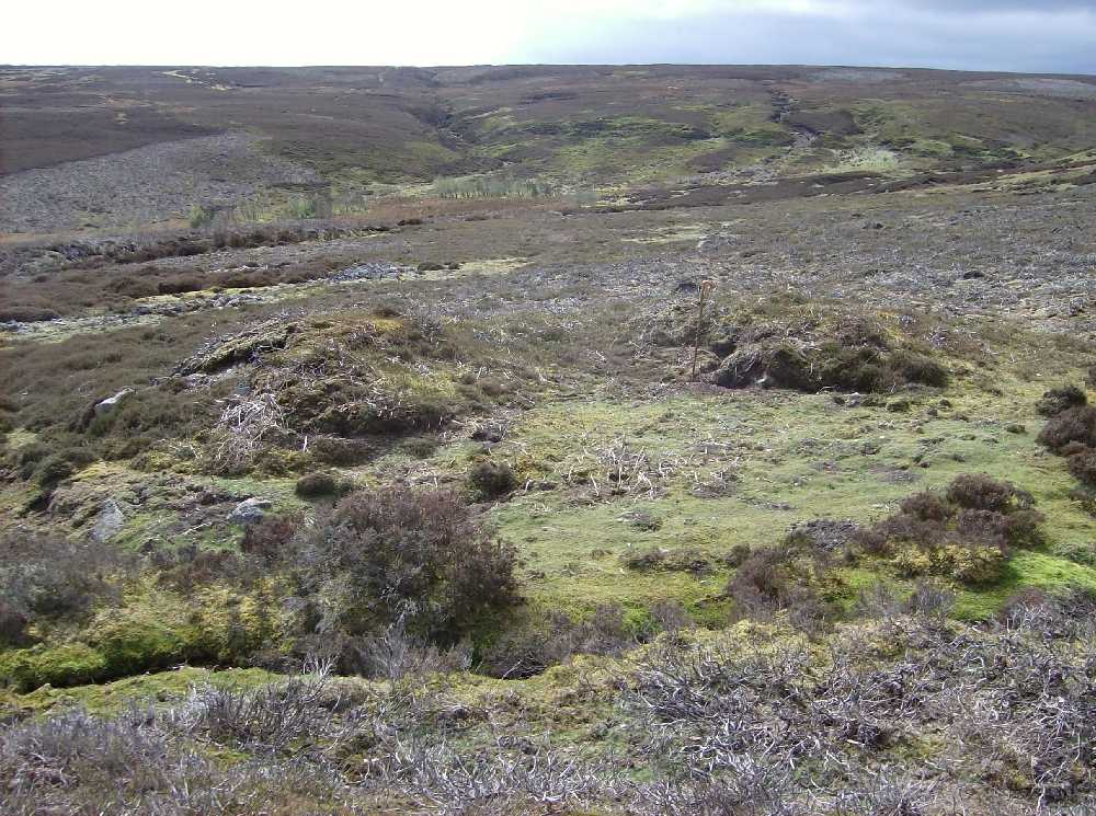
4.2 Burnt Mounds.
The general distribution throughout the Ure, Swale and
Tees-Greta Uplands of the very numerous burnt mounds is
indicated on Figure 14. Burnt mounds are semi circular
discard heaps of fire cracked sandstone arranged around a
central depression which marks the location of a trough. See
Figures 22-25. These sites range in size from 4m to 18m
diameter but most are from 8m-15m diameter. Hearths may be
sited below, on or in the vicinity of the mounds. Burnt
mounds are always located at the most constant springs which
rise below the Main and Underset Limestones or on the banks
of low energy streams. For clarity,
not all the 150 or so burnt mound sites recognised to date
are shown on this map, which is based on Laurie 2003, Figure
69. Burnt mounds can be regarded as indicators for the
presence, in the vicinity of favoured springs, of the
seasonal encampments of the same transhumant herdsmen
hunters who can be regarded as having made the rock art, or
their direct successors, since the burnt mounds continued to
be used for several centuries after the practice of making
rock carvings was forgotten.
|
|
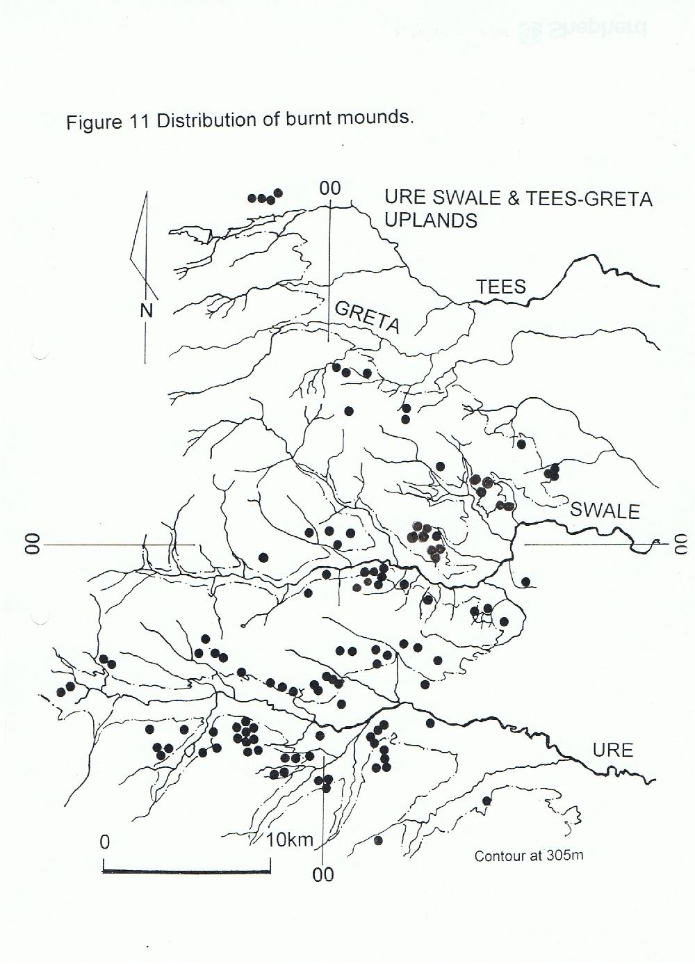
Figure14
Ure, Swale and Tees-Greta Uplands. Distribution of Burnt
Mounds.
|
|
The distribution of burnt mounds in the northern Dales is
far more widespread than rock art and, again is not random;
they are located at the most constant springs, generally
above 300m OD at regular intervals of 1km or so, Photo 22, unlike the rock art which, except for one or two isolated
examples in burial mounds, is absent from Upper Swaledale
and from Wensleydale. |
|
Photo
22: Burnt Mound Site 1 Long Scar Spring
|
|
In general, the rock art is regarded as of Late
Neolithic / Early Bronze Age Date, whereas the very numerous
radiocarbon dates from primary contexts within excavated
burnt mounds indicate that these sites were used from the
Late Neolithic, at around 2400BC, to the Late Bronze Age -
not much later than around 800BC.
The framework suggested here for this transhumant way of
living assumes that the Late Neolithic and Bronze Age
herdsmen communities who made the rock art and who used the
burnt mound sauna / sweat house sites shown on Figures 13 and
14 would return at the onset of autumn to their main year
round tribal settlements located at lower elevations in the
Vale of Mowbray on the light fertile soils of the gravel
terraces of the Tees, Swale and Ure Lowlands where
concentrations of Late Neolithic Monuments, as at Catterick,
West Tanfield and Boroughbridge mark their tribal settlement
areas.
Scraper dominated lithic scatters and stray lithic finds
provide further evidence for the actual location of their
encampments and their activities in the landscape. For
representative lithic finds in Swaledale and Wensleydale,
see Laurie 2003.
The juxtaposition of all this evidence can provide an
insight into the way of life of the pioneering herdsmen,
hunters who made the rock carvings.
The rock art is their signature on the landscape, the
burnt mounds their footprint. (Bradley 1992, 1993, 1997.
Laurie 2003, 2004).
This is the context in which rock art sites and burnt
mounds should be considered and this is the real
significance of the carved rocks. Much effort and print has
been expended in recording the detail of the carvings.
However the carvings cannot be understood and are mere
curiosities without context.
Boulders decorated with simple cup marks and occasionally
with more complex figures are occasionally incorporated
within round barrows (burial mounds of Late Neolithic / Early
Bronze Age Date). The locations of cup marked burial mounds
in this area are indicated on Figure 13 which is based on
Laurie 2003, Figure 71.
For details of the rock art sites on the Ure, Swale and
Tees-Greta Uplands, see Beckensall and Laurie 1998.
A characteristic burnt mound, one of four burnt mounds
located within the Army Feldom Ranges at the same spring
rise, was recently excavated by Archaeological Services
University of Durham, on behalf of Defence Estates (Laurie
2007. 'Excavation of an Enigma'. Conservation Update.
Defence Estates), photos 23 -25. The excavated mound was
radiocarbon dated to between 1430-1260BC, some 1000 years
later than a sample taken from an adjacent burnt mound at
the same spring which was dated to 2400BC.
|
|
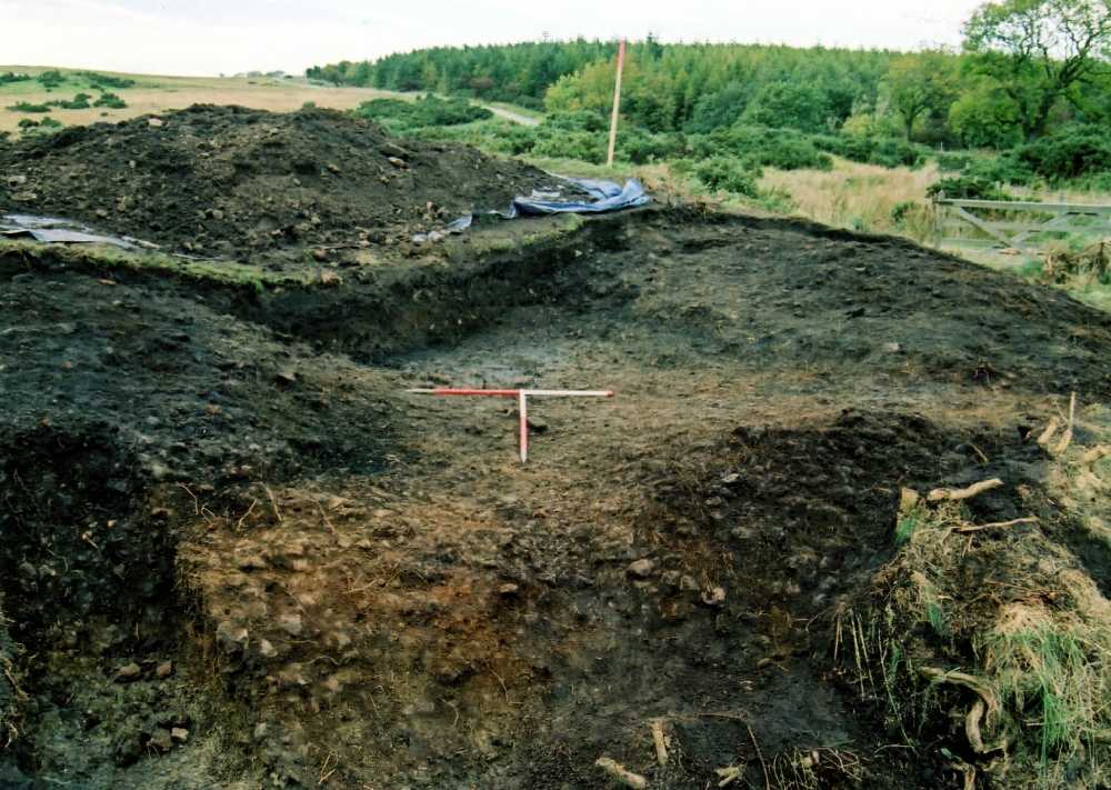
Photo
23: Sturdy Springs, Army Range, Feldom. Burnt mound after
removal of turf.
|
|
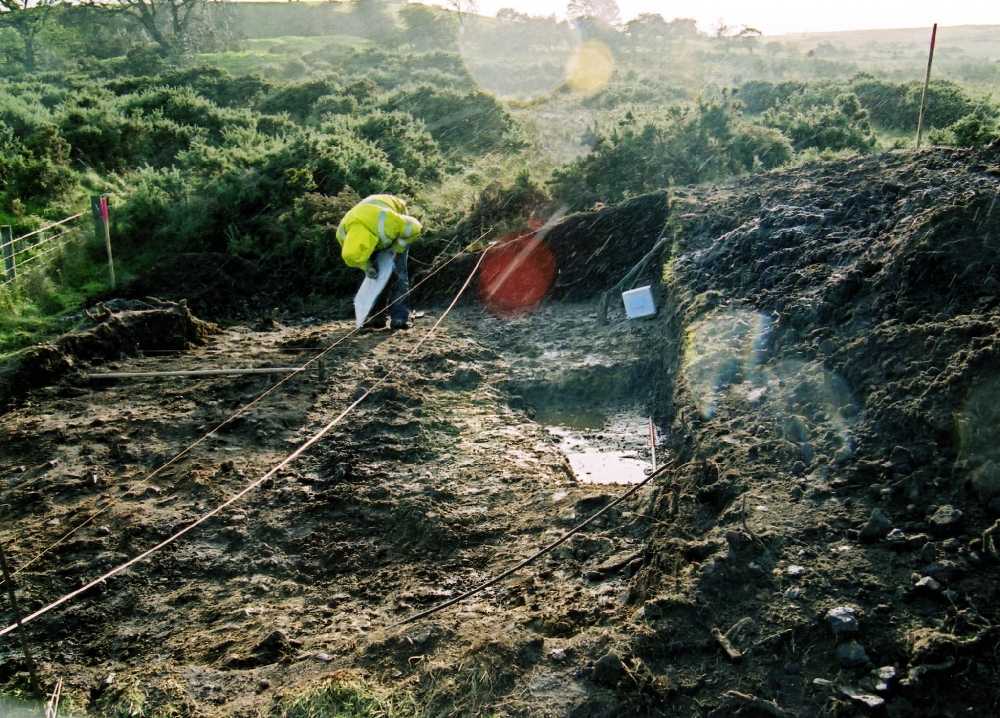
Photo
24: Sturdy Springs, Army Range, Feldom. Burnt mound. The
trough.
|
|
Photo
25: Sturdy Springs Hearth
The significance of the numerous burnt mounds
undoubtedly lies with their potential for future research as
indicators of contemporary settlements which have left no
other surface trace of their existence. Secondly, these
highly compacted mounds protect the ancient land surface,
often in a wet situation which can provide the opportunity
to investigate the environment contemporary with the initial
use of the sites. See for example: Topping, P. 1998. The
Excavation of Burnt Mounds at Titlington Mount, North
Northumberland, 1992-3. Northern Archaeology. Volume 15
/ 16.
1998.
5 Conclusion
This account of the coaxial field systems of Swaledale is
not the end of the story. It is confined to areas in the
vicinity of Reeth which have been surveyed in detail.
Further areas of Swaledale with evidence of early settlement
which have not yet received the same level of attention are
indicated on Figure 1. It is intended that these will be the
subject of detailed survey by the Swaledale and
Arkengarthdale Archaeological Group.
Within the areas described here, the first priority for
future research should be the investigation and dating of
the Phase 1 unenclosed settlement (Key location G2.
Figure 2) south of Grinton Lodge, the Phase 2 coaxial
boundaries themselves and the multi period settlements on
Harkerside west of Grinton Gill (Key Location H2,
Figure 3). On Calverside, detailed survey and excavation of
the platform settlements above Barney Beck in the Pastures
of Low Cringley and on moorland above Thirns and Nova Scotia
would be a priority (Key Locations R3, R4 and R5,
Figure 7).
We have set out to answer three questions, the first of
which was to determine the relationship between the coaxial
field systems and the Bronze Age cairnfield settlements.
This relationship has been generally confirmed: the coaxial
field systems of Swaledale developed from unenclosed Bronze
Age settlement.
The coaxial field systems incorporate early curvilinear
enclosures which, if these prove to be the local equivalent
of palisaded enclosures, may form the settlements at the
onset of the construction of the coaxial field systems
during the Late Bronze Age. Evidence for earlier
settlements, visited each summer by transhumant (seasonal)
pastoral herdsmen is confirmed by lithic scatters and the
numerous burnt mounds. Burnt mounds are discard heaps of
fire cracked stone best interpreted as sweat house / saunas
established by repeated occupation of favoured locations at
springs rising below the Main and Undersett Limestones
(Laurie. 2003).
Secondly, it can be confirmed that in certain locations,
the visible high elevation coaxial field systems were
respected and incorporated within later field systems which
relate to settlements located at lower elevations.
Finally, this paper has demonstrated that the extensive
coaxial field systems of Swaledale were relevant to early
farming communities from the Bronze Age through to the Roman
occupation and beyond but still unanswered is the context
for the coaxial fields: who planned and ordered the
construction of this organised landscape?
In their most developed form it is suggested the coaxial
field systems represent an organised planned landscape
constructed and occupied by shepherd / herdsmen owing their
allegiance to a powerful Iron Age hierarchy,
absentee aristocratic estate owners. Did this aristocracy
whose ‘Great Houses’ may have been at Stanwick, Piercebridge
or at Catterick, (Turnbull and Fitts 1988) spend their
leisure time hunting from their equivalent of country
shooting lodges: perhaps at Maiden Castle or at the defended
settlement below Whitcliffe Scar, East Applegarth. Were the coaxial field systems designed by these
aristocrats (some haughty Cartimandua?) as sheep runs in an
attempt to benefit from a surging cross Channel trade in
finished woollen goods (Wild,1978).
|
|
Table of Contents:
Introduction
Notes on the maps and fieldwork.
1 Coaxial field
systems in Swaledale - a reassessment.
1.1 Summary
2 Previous archaeological work on field systems in Swaledale,
the nature of the evidence.
3 The Coaxial
field systems.
3.1 Grinton Moor.
3.1.1 Description of Grinton Moor.
3.1.2 Chronology of the Grinton Moor Coaxial
Field system.
3.2 Harkerside Moor
3.2.1 Description of the Harkerside coaxial
field systems.
3.2.2 Harkerside Moor East.
3.2.3 Chronology of the Harkerside Moor East
Field System.
3.3 Harkerside West.
3.3.1 Chronology of the Harkerside Moor West
Field System.
3.4 Two unsurveyed coaxial
field systems.
3.5 Unenclosed Settlement and
coaxial field system east of Browna Gill, Low Whita.
(Unsurveyed).
3.6 Coaxial field system on
Low Row Pasture and platform settlement at Rowleth Wood.
3.7 Reeth Low Moor -
Calverside
3.7.1 Description.
3.8 Reeth Low Moor -
Calverside West.
3.8.1 Chronology of the Calverside West Field
System.
3.9 Marrick Moor including
Copperthwaite and Raygill Allotments.
3.9.1 Chronology of the Marrick Moor field
system.
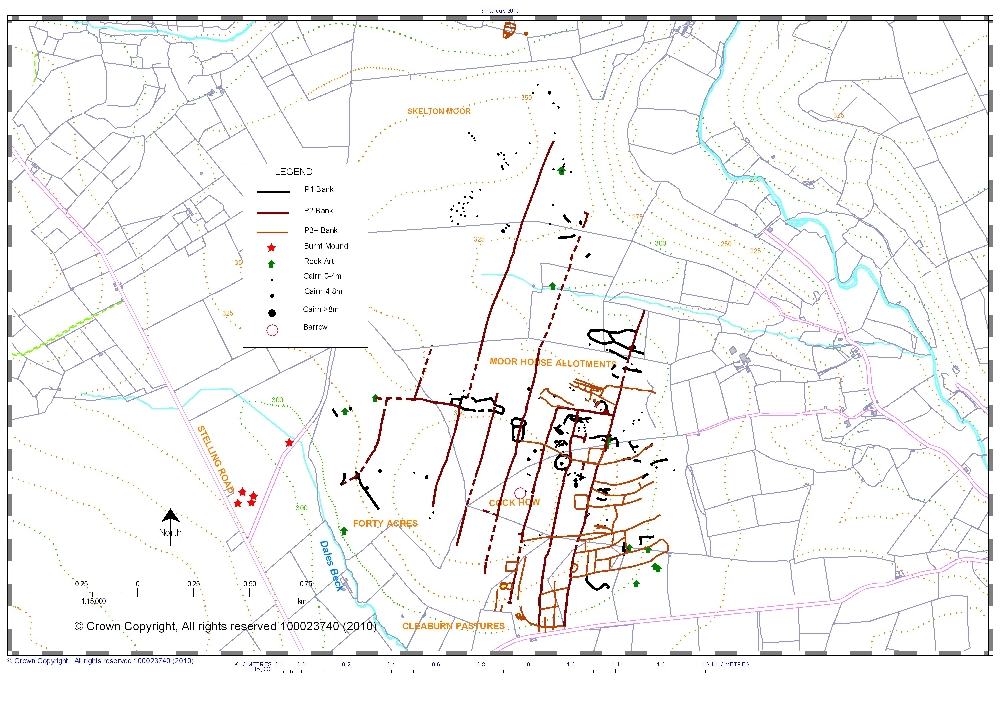
3.10 Marske. Skelton Moor including Forty Acres, Cleaburn Pasture, Cock How and Moor House Allotments.
3.10.1 Chronology of the Skelton Moor Coaxial Field System.
4 Notes on
the general distribution and context of Rock Art and Burnt
Mounds on the North East Pennine Fringe.
4.1 Rock Art.
4.1.2 Rock art of the Libian Sahara.
4.1.3 Alpes Maritimes, Vallee de Fontanalbe.
4.2 Burnt Mounds.
5 Conclusion
Table of Contents
Appendix 1: Figures and Captions.
Appendix 2: Photographs.
References.
Copyright Notice
Appendix 1: Figures and
Captions.
Figure 1. Swaledale. Coaxial field systems.
Figure 2. Grinton Moor, from Cogden Gill to Grinton Gill.
Key Locations mentioned in the text:
G1: Coaxial abutting earlier settlement boundary.
G2: Unenclosed settlement with four large round house
enclosures.
G3-G7: Enclosures and possible settlements
Figure 3. Harkerside Moor from Grinton Gill to Maiden
Castle.
Key Locations mentioned in the text:
H1–G5: for details, see below Figures 5 and 6.
Figure 4. Harkerside East, from Grinton Gill to Deer
Park.
Key Locations mentioned in the text:
H1: Harker Mires: cairnfield, ring cairn, burnt mounds
and coaxial field system.
H2: Settlements west of Grinton Gill and coaxial field
system.
H3: Two late field boundaries abut earlier coaxial field
boundary.
Figure 5. Harkerside West from Deer Park to Maiden
Castle.
Key Locations mentioned in the text:
H4: Groups of small cairns (some within small fields) on
all cultivatable areas and burnt mound above Harkerside
Place. Coaxial field boundaries and trackways.
H5: Maiden Castle in context, showing limit of field system 0.2km
west of Maiden Castle, small cairnfield and extended top
dike boundary aligned on the earthen round barrow south west
of Maiden Castle.
Figure 6. Reeth Low Moor.
Key Locations mentioned in the text:
R1-R5 for details, see below Figure 7.
Figure 7. Reeth Low Moor. Calverside West.
Key Locations mentioned in the text:
R1: Cringley Hill. Settlements, field system terminating
at 400m OD., burial cairns, burnt mound, ring cairns,
cairnfields, enclosures, lithic finds.
R2: Location of radiocarbon dated section through field
boundary.
R3: Calverside above Nova Scotia. Two field systems, the
lower terminating at 360m, the upper at 400- 425m OD,
platform settlements, cultivation terraces, clearance
cairns, two burnt mounds, lithic finds.
R4: Low Cringley and Barney Beck pastures. Platform
settlements, cultivation terraces, clearance cairns and
burnt mound.
R5: Calverside above Thirns. Two field systems, the lower
terminating at 360m OD, the upper at 410m OD. Seven burnt
mounds.
Figure 8. Marrick Moor and Skelton Moor. Coaxial field
systems.
Figure 9. Marrick Moor. Fremington Edge, Copperthwaite
Allotment and Owlands Allotment. Bronze Age settlements,
burnt mounds and coaxial field system.
Key Locations mentioned in the text:
M1: Fremington Edge. Enclosure with round cairn and three
aligned field banks, small cairns and abutting coaxial.
M2: Fremington Edge. The Radio Mast Site. Enclosure with
ring cairn or round house, small cairns and circular
structure.
M3: Fremington Edge West Site. Ring cairn or round house,
small cairns and field banks. Lithic finds.
M4: Stelling. Dales Beck. Unenclosed settlement with
abutting coaxial, five burnt mounds and rock art sites.
M5: Unenclosed platform settlement below Fremington Edge.
Figure 10. Marske. Skelton Moor including Forty Acres,
Musgrove or Cleaburn pasture, Cock How and Moor House
allotments. Early Phase 1 cairnfield settlement.
Key locations mentioned in the text:
K1: Circular Phase 1 enclosure with cairns, ring cairn
and two cup marked rocks.
K2: Ovoid Phase 1 enclosure slighted by later field
clearance and mining activity.
K3-K5: Grouped enclosures crossed by Phase 2 coaxial
boundaries.
K6: Unenclosed platform settlement east of Dales Beck.
K7: Cleaburn Pasture. Unenclosed platform settlements.
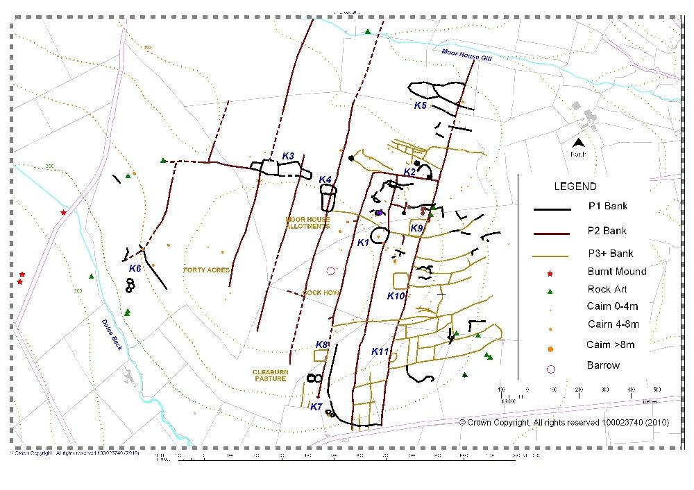
Figure 11. Marske. Skelton Moor including Forty Acres,
Musgrove or Cleaburn pasture, Cock How and Moor House
allotments. Main Phase 2 coaxial field system and later
settlements.
Key Locations mentioned in the text:
K1: Circular Phase 1 enclosure incorporated within
coaxial field system.
K2: Ovoid Phase 1 enclosure slighted by later field
clearance and mining activity.
K3-K5: Grouped enclosures crossed by Phase 2 coaxial
boundary
K6: Unenclosed platform settlement east of Dales Beck.
K7: Cleaburn Pasture. Unenclosed platform settlements.
K8: Cleaburn Pasture. Rectangular enclosure attached to
coaxial boundary.
K9: Cock How. Rectangular enclosure attached to coaxial
boundary.
K10: Cock How.Sub-rectangular enclosure overlies coaxial
boundary.
K11: Cleaburn Pasture. D shaped enclosure and field
system subtended from coaxial boundary.
K12: Unenclosed settlement and field system.
Figure 12. Marske. Cock How.
Figure 13 Prehistoric sites between Rivers Swale and
Tees
Figure 14 Ure, Swale and Tees-Greta Uplands. Distribution
of Burnt Mounds
Appendix 2: Photographs.
Photo1. Reeth and Upper Swaledale from Reels Head.
Coaxial field systems reach elevations above 400m OD on both
sides of the Dale from Marske to Gunnerside.
Photo 2: Grinton Moor. Coaxial field boundary at 410m OD at
Ridley Hush
Photo 3: Grinton Moor. Round house enclosure south of
Grinton Lodge Youth Hostel.
Photo 4: Harkerside Moor East. Coaxial.
Photo 5: Harkerside Moor. Ring cairn at Harker Mires.
Photo 6: Ellerton Moor. Field system aligned on small
standing stone. Three burnt mounds nearby.
Photo 7: Reeth Low Moor. Coaxial of the Reeth System on
Riddings Rigg.
Photo 8: Fremington Edge. Coaxial at the Radio mast Site.
Photo 9: Copperthwaite Allotment. Coaxial at 420m OD.
Photo 10 Cup marked rock. Munn End. Skelton Moor.
Photo 11 Cup marked rock. Pastures below Cock How (Private
land).
Photo 12 Cup and ring marked boulder, possibly originally in
one of the small cairns nearby.
Photo 13 Cup marked rock. Forty Acres. See Current
Archaeology 241. April 2010, p9 for details of the
extraordinary decoration on this rock revealed after removal
of the turf covering.
Photo 14: Libya; Tadrart Acacus; Wadi Teshuinat. Mosque at
parking area below Rock Shelter
Photo 15: Libya; Tadrart Acacus; Wadi Teshuinat Uan Amil.
Barbary Sheep hunted
Photo 16: Libya; Tadrart Acacus; Uan Amil
Mesolithic-Neolithic transition. Man and domesticated
Barbary sheep
Photo 17: Libya; Tadrart Acacus; Uan Amil. Cup marked rock
Photo 18: Libya. Messak. Cup and Ring marked rock above
decorated rock Shelter. Photo: Albada and
Albada 2000, Figure 87
Photo 19: Alpes Maritimes, de Vallee de Fontanalbe.
The transhumance
Photo 20: Alpes Maritimes. Monte Bego. Oxen and Plough
scene.
Photo 21: Alpes Maritimes. Monte Bego. Fields and settlement
carving
Photo 22: Burnt Mound Site 1 Long Scar Spring
Photo 23: Sturdy Springs, Army Range, Feldom. Burnt mound
after removal of turf.
Photo 24: Sturdy Springs, Army Range, Feldom. Burnt mound.
The trough.
Photo 24: Sturdy Springs Hearth
Aerial Photo 1: Marske. Coaxial field system crossed by the
Cleaburn Pasture lead mining ground.
Aerial Photo 2: Marske. Cleaburn Pasture. D-shaped enclosure
and field system subtended from coaxial.
Note: Aerial photographs courtesy of NYCC
References.
Barnatt, J., 1987. Bronze Age settlement on the East
Moors of the Peak District of Derbyshire and South Yorkshire.
Proceedings of the Prehistoric Society 53, 393-418.
Beckensall, S. and Laurie, T.C., 1998. Prehistoric Rock
Art of County Durham, Swaledale and Wensleydale.
Bradley, R. 1992. Turning the world - rock carvings and
the archaeology of death. Sharples, N. and Sheridan, A.
Eds. 'Vessels for the Ancestors' Routledge.
Bradley, R. 1993. Altering the Earth. The origins
of monuments in Britain and Atlantic Europe. Edinburgh.
Bradley, R. 1997. Rock Art and the Prehistory of Atlantic
Europe. Signing the Land. Routledge.
Coggins, D. and Fairless, K.J., 1984. The Bronze Age
Settlement at Bracken Rigg, Upper Teesdale, Co Durham.
Durham Archaeological Journal 1, 5-21.
Caulfield, S., 1983. The Neolithic settlement of north
Connaught. BAR British Series 116, 195-216.
Fleming, A.F and Laurie, T.C., 1985-1994. The Swaledale
Ancient Land Boundaries Project, Interim Reports 1-10.
Fleming, A., 1988. The Dartmoor Reaves. Batsford.
Fleming, A., 1998. Swaledale. Valley of the Wild River.
Edinburgh University Press.
Gates, T., 1983. ‘Unenclosed settlements in
Northumberland’ in Chapman, J.C and Mytum, H.C. (eds)
Settlement in Northern Britain, 1000BC-AD1000, British
Archaeological Reports, British Series, 118. 103-148.
Gates, T., 2009. Excavation of a Late Second / Early
First Millenium BC Unenclosed Round House at Halls Hill near
East Woodburn, Northumberland. Archaeologia Aeliana.
Fifth Series, Vol XXXV111, 43-85.
Jobey, G. and Tait, J., 1966. Excavations on palisaded
settlements and cairnfields at Alnham, Northumberland.
Archaeologia Aeliana.’ Vol XLIV, Fourth Series, 1966.
Laurie, T.C., 1985. ‘Early Land Division and Settlement
in Swaledale and on the eastern Approaches to the Stainmore
Pass over the North Pennines’. Spratt and Burgess,1985.
Upland Settlement. The Second Millennium BC and after.
British Archaeological Reports British Series 143. 135-162.
Laurie, T.C., 2003. ‘Researching the Prehistory of
Wensleydale, Swaledale and Teesdale’. In Manby,T.G.,
Moorhouse,S. and Ottaway, P., (eds.) The Archaeology of
Yorkshire. Yorkshire Archaeological Society Occasional Paper
3, 223-253.
Laurie 2007. Excavation of an Enigma. (Conservation
Update Defence Estates).
Raistrick, A., 1935. ‘Prehistoric cultivations at
Grassington West Yorkshire’, Yorkshire Archaeol. J. 34,
115-50
Spratt, D, and Burgess, C., (eds) 1985. Upland
Settlement. The Second Millennium BC and after, British
Archaeological Reports British Series 143.
Turnbull, P., 1984. Stanwick in the Northern Iron Age.
Durham Archaeological Journal 1, 41-49.
Turnbull, P. and Fitts, L., 1988. The Politics of
Brigantia. Price, J, Wilson, P.R., Briggs, C.S. and
Hardman, S.J., eds., Recent Researches in Roman
Yorkshire.BAR British Series 193, 377-386.
The Gardom’s Edge Project.
Link no longer working
White, R., 1997. The Yorkshire Dales. Landscapes through
Time. Batsford.
White, R. and Wilson, P., (eds.). 2004. Archaeology and
Historic Landscapes of the Yorkshire Dales. Yorkshire
Archaeological Society Occasional Paper 2.
Wild, J.P. 1978 in: du Plat Taylor, J. and Cleere, H. (eds).
Roman shipping and trade: Britain and the Rhine Provinces.
CBA Research Report 24, 79-81.
Vyner, B., 2007. A Great North Route in Neolithic and
Bronze Age Yorkshire. The evidence of Landscape and
Monuments, Landscapes, 8.1, 69-84.
Van Albada, A. and A.M. 2000. La Montagne
du Hommes - Chiens. Art Rupestre du messak Libyen'
Seuil.
Young, R., Fieldwork and excavation at the Crawley
Edge cairnfield, Stanhope, Co.Durham. Durham
Archaeological Journal 8,1992, 27-49. |

Coaxial Field Systems in Swaledale by Laurie, T.C., Mahaffy, N.W. and White, R.F. is licensed
under a Creative Commons Attribution-NonCommercial-NoDerivs 3.0 Unported License.
|
|
Webpage: S P Eastmead |
|