|
Swaledale and Arkengarthdale Archaeology Group The Swaledale Project 7000 Years of a Landscape and its People Registered Charitable Incorporated Organisation Number 1155775 |
|
Hagg Farm Site 103 Feature 407
Excavation Proposal Excavation Proposal document pdf download Contact seastmead@gmail.com if you want to be included in future emails. |
|
Preliminary
work The initial trench will be located from the approximate centre of the walled enclosure northwards for 9 metres. Initially it will be a 4 metre wide trench with scope to widen it if indicated. See diagram: 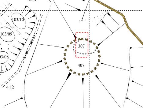 Around the enclosure are a number of hawthorns that we will have to work around if we widen the trench. Fully recording all 19C structures will be our first priority. A 266m datum has been located beside the dry stone wall to the north of the mound. A datum line has been marked by placing three more posts: one in the approximate centre of the enclosure and the other two 10m due north and 10 due south of the centre. A 20 x 20 metre matrix of levels at 2 metre intervals has been taken across the mound either side of of this North-South datum line See: Glacial Mound levels .xls Approximate position of wall spread relative to measure levels |
| YouTube animation of Glacial Mound
Levels View Full Screen Note the levels range from 263 to 267 metres AOD. The z axis is exaggerated by plotting level AOD - 260m. |