|
|
The Swaledale and Arkengarthdale
Archaeology Group (SWAAG)
Archaeological Report No.
1
The Fremington Project
An Iron Age/Romano-British Landscape at Hagg Farm
Tim Laurie, Stephen Eastmead and Peter Denison-Edson
21st
July 2010
|
|

Figure 1: Hagg Farm site from Fremington
looking towards Reels Head.
Photo: S. Eastmead 11/11/2009
|
|
Summary
This report
describes an open settlement landscape of Late
Prehistoric/Romano-British character centred on the pastures
of Hagg Farm, Fremington, near Reeth in Swaledale. These
ancient settlements of small farms and fields are centred at
West Hagg, SE055989, 240m OD, but also extend across the
pastures of the adjacent modern farms of Sorrel Sykes above
Ewelop Hill and of Marrick Priory Farm to the south of the
Fremington to Marske road (unsurveyed).
The settlement
complex comprises nine small separate farmsteads, located at
intervals within a contemporary coaxial field system, on
rising ground above the Swale flood plain east of the
junction of Arkle Beck and the River Swale (Figure 2).
|
|
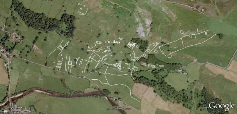
Figure 2: Hagg Farm site shown in Google Earth
with GPS archaeology overlay.
|
|
The field system is
defined by by strongly lynchetted or stone-banked coaxial
field boundaries (i.e. with parallel boundaries sharing a
common axis) aligned at right angles to the slope on a
WSW-ENE axis (Figure 3).
|
|
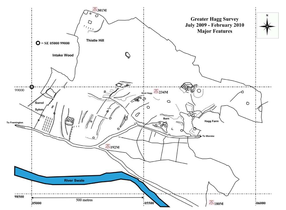
Figure 3: Hagg Farm and Ewelop Sites.
|
|
These settlements
are as yet undated by excavation. However the whole complex
closely resembles the Late Prehistoric/ Romano-British
settlement landscape above and east of Healaugh, surveyed
and excavated during the Swaledale Ancient Land Boundaries
Project (SWALB), (Fleming and Laurie, Third Interim
Report, 1986 Season et seq.) [http://www.swaag.org/publications_TimLaurie.htm]
A second coaxial field system (201) aligned on a different
SW-NE axis extends upslope to reach 350m OD at Reels Head.
This second field system can also be regarded as
contemporary with the settlement complex at Hagg Farm (Figure
4).
|
|
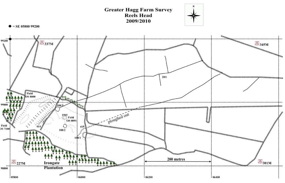
Figure 4: Hagg Farm map – Reels Head section showing
coaxial field system 201.
|
|
It has not proved
possible to associate these coaxial field systems with the
coaxial field system on Copperthwaite Allotment (Figures
5, 39, 41 and 42) to the NE of Fremington. This latter
field system, which was surveyed during 1985, is aligned on
a different, NNE-SSW, axis and is associated with a
settlement complex of Bronze Age character located at a much
higher elevation, generally above 400m OD, on and
immediately below Fremington Edge.
See Section 6: Field Systems for a brief description of
these Bronze Age settlements and the associated coaxial
field system which extends across Marrick Moor,
Copperthwaite Allotment and beyond (Fleming and Laurie,
Second Interim Report, 1985 Season and Laurie 2003).
The Hagg Farm
settlement complex reinforces the conclusion that the
density and distribution of Late Prehistoric/Native Roman
Iron Age farmsteads located within the present day
drystone-walled pastures, was similar to that achieved when
the population of farmer-miners in Swaledale was at its peak
during the 19th Century.
The field system
associated with the Late Prehistoric/Romano-British
farmsteads was respected by later farming, and it is clear
that the fields were cultivated intermittently throughout
subsequent periods to the present day.
1.
Introduction
Aerial survey by Paul Chadwick of the
North Yorkshire County Council (NYCC) and by Robert White of
NYCC and the Yorkshire Dales National Park, together with
landscape surveys commenced during the 1970s by T.C. (Tim)
Laurie, led to the formation of the Swaledale Land
Boundaries Project 1984-1993 (SWALB). Over a ten year
period SWALB, directed by Andrew Fleming, then of the
Department of Archaeology and Prehistory at the University
of Sheffield, and Tim Laurie, identified and recorded rich
prehistoric/early historic landscapes in Swaledale
characterized by extensive co-axial field systems on open
moorland above the limit of present day walled pastures and
associated with unenclosed cairnfield type settlements of
Bronze Age date. SWALB also recognized a Later Prehistoric
Iron Age and Romano-British landscape of farms and
settlements within the present day pastures on the lower
dale slopes, generally below 300m OD.
In April 1997, Ed Dennison Associates (EDAS),
commissioned by English Heritage and the Yorkshire Dales
National Park Authority, completed an archaeological survey
and report of Hagg Farm, Fremington, Swaledale which
identified over 90 features of historic and archaeological
interest within the 69 hectares of Hagg Farm, and
recommended more intensive survey of many of the features,
principally boundaries and possible farmstead sites visible
as earthworks, which they had recorded as prehistoric/early
mediaeval in date.
While the archaeology of Hagg Farm had
not been included within the area surveyed by the SWALB
Project, subsequent walk-overs by Tim Laurie together with
desk-top research using Google Earth suggested that the area
in the western part of the farm, around the house at West
Hagg, would repay more intensive study, building on the EDAS
report. From July 2009 Tim Laurie led site ‘walk-overs’ with
members of the newly formed Swaledale and Arkengarthdale
Archaeology Group (SWAAG), who subsequently surveyed the
surface archaeology present on Hagg Farm land.
2.
Location and Geology
Location
The settlement complex centred on the West Hagg farmhouse
occupies the western part of Hagg Farm which lies on the
north side of Swaledale, between Low Fremington and Marrick,
centred on NGR SE 060990. Hagg Farm is bounded to the south
by the Low Fremington to Marrick road up to Reels Head, and
to the north by Fremington Edge, rising from approximately
200m OD in the south-west below West Hagg to approximately
410m OD above Fremington Edge. Land-use is predominantly
meadow with rough pasture on higher ground to the north.
Survival of ancient field boundaries and settlement sites
within these pastures is generally very good, features being
prominent as visible earthworks in open ground and (in the
case of field boundaries) underlying later dry-stone walls.
|
|

Figure 5: Fremington Project Study Area
|
|
Geology
Swaledale lies within the northern sector of the
Askrigg Block formed from repeated
near-horizontal layers of limestone, shale and sandstone of
the Carboniferous Limestone (Yoredale) Series, topped with
Millstone Grit. The lower slopes of Hagg Farm and the
pastures above Ewelop Hill mirror this broad geology, with
glacial drift deposits overlying the hard rock strata,
forming terraces separated by steeper slopes sweeping down
towards the River Swale flood plain.
Hagg Farm lies on the line of the Stockdale Fault which
drags down the Main and Underset Limestones which form the
scarp of Fremington Edge at 400m OD towards the road at
Reels Head at 250m OD. (Figures 1 & 6).
|
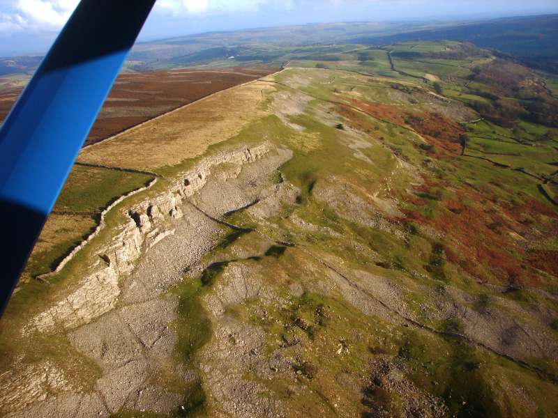
Figure 6: Fremington Edge, from
Jabz Cave towards Reels Head.
Photo: S. Eastmead 11/11/2009
|
|
The soil is
generally typical brown earth, a well-drained loamy soil
overlying slowly permeable subsoils with slight seasonal
waterlogging. The sloping nature of the site means that soil
creep is a significant factor in assessing the size and
extent of settlement features.
3.
Study Definition
The SWAAG Hagg Farm study aims to carry
out a large scale survey of features in part recognized and
delineated on a smaller scale by EDAS and by Laurie in his
work on field systems and settlement patterns in the area.
The current phase of the Project concentrates on Hagg Farm
and has been extended to include the prominent scooped
settlements north of Ewelop Hill (Site 104) together with
adjacent areas to the west of the farm boundary recognizing
that the archaeological remains underlie current landholding
boundaries and modern field patterns.
|
|
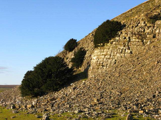
Figure 7: The Main Limestone at Fell End, Fremington Edge.
Photo: R Carter 14/12/2009
|
|
It is intended that the Hagg Farm
Survey and the Fremington Project (the working title for a
series of current and future surveys of the land above and
below the length of Fremington Edge) will include records of
ancient trees and relict hedgerows as additional potential
indicators of historic vegetation patterns and landscape use
(Figure 7).
4.
The Survey
Methodology
Features were surveyed using
commercially available good quality hand-held GPS
devices configured to use the British National Grid (BNG) and the
OSGB36 datum. These were trialled to test for accuracy
compared with traditional survey methods and tested against
site plans produced by traditional methods. These tests
suggested that in most cases satisfactory accuracy could be
achieved for the purposes of recording the locations of
archaeological features down to approximately 4m to 5m in
diameter. This seems to be at odds with the reported
accuracy displayed on these devices, but that parameter
relates to the accuracy of the waypoint measurement in
respect to the BNG co-ordinates, and not the relative position
of one waypoint to the next. The grid inaccuracy is
insignificant when reducing the data down to the size of a
published A4 map. The maps are scaled to be viewed as
an A4 document (see link below).
The maps produced were generated using
a combination of free and low cost (£20) software using the
following stages: GPS waypoints were
downloaded into GPS TrackMaker (freeware) and lines were
drawn connecting appropriate waypoints to describe both
field boundaries and archaeological features.
1)
When complete, an image of the final GPS TrackMaker
screen was saved as a .jpg image file.
2)
The TrackMaker image was then imported into the
graphics program DrawPlus8, as Layer 1.
Additional layers
were generated using functions within DrawPlus8, to produce
archaeological maps by tracing over the baseline GPS
TrackMaker Layer 1, using suitably configured lines and symbols
in conjunction with the feature description from the survey
log and the survey photographs.
Typically four additional layers were generated:
a. British National Grid
b.
Field Boundaries
c. Archaeology
d.
Text Labels
On more complex maps,
archaeology was divided into different layers e.g.
Settlements, Mounds and Cairns, Trackways, Lynchets etc. A
full description of the methodology is available at
https://swaag.org/publications.htm All SWAAG maps were
drawn by S.P. Eastmead using this technique. A print
friendly A4
version of the SWAAG Maps is available at
http://www.swaag.org/pdf/HaggReport1Maps.pdf
5. Settlements
General
Interpretation of earthworks from surface
observation is fraught with risk. Since the descriptions of
sites and features which follow are based on above-ground
observation they must be regarded as provisional pending
confirmation by future excavation. Nevertheless, the
experience gained during the excavation of the platform
settlement above Healaugh (Fleming and Laurie, SWALB Interim
Reports, and Fleming 1998), which was morphologically very
similar to those described below, has formed the basis for
the assignment of the settlements and the field system
centred at West Hagg to the Late Iron Age/Romano-British
period.
|
|
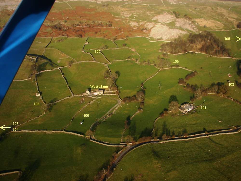
Figure 8: West Hagg pastures from the south. Photo: S.
Eastmead 11/11/2009
|
|
Furthermore, there was no evidence for
later settlement activity, including reoccupation of the
platform settlements. Nor did this survey identify any
structure of rectangular plan which are so characteristic of
medieval settlement. This is not to say that the field
system was not reoccupied and cultivated throughout
subsequent centuries, as it most certainly was.
Settlements are usually within
enclosures defined by lynchet boundaries which occasionally
show sections of stonework. It can be assumed that these
lynchetted boundaries were originally stone revetted and
subsequently quarried out to provide material for stone
walling. Similarly the house platforms, made by cutting into
the hillslope and using the excavated material to fill and
level the front edge of the platform, are also defined by a
rear scarp and front apron.
Hagg
Farm Settlements
The survey identified nine platform settlements
located within the present pastures of Hagg Farm and Sorrel
Sykes Farm. Settlements sites 100 to 107 are directly
associated with coaxial field system 200 which is defined by
strongly lynchetted and stone embanked boundaries. The
settlements together with the field system form an open
‘township’ or village-type settlement, with settlements
situated at intervals within their contemporary fields
running down towards the flood plain. Similarly, settlement
site 108 is associated with coaxial field system 201. It is
considered that all the farmstead settlements were occupied
during the same general period.
The close similarity between this
dispersed ‘township’ landscape to that of the settlement to
the east of Healaugh (Fleming and Laurie1983-1994, Fleming
1998), together with occasional finds of Roman pottery
sherds (Figure 23) and the two beehive quern-stones
from stone walls near West Hagg (Figure 47), supports
the supposition that this settlement complex was probably
established during the Late Prehistoric Iron Age; with
occupation extending through the period of the Roman
Occupation.
The platforms all seem to have
supported circular structures, and there is no direct
surface evidence in the form of rectangular stone founded
buildings or finds of medieval pottery sherds to indicate
medieval reoccupation of these settlement sites.
Nevertheless, the Hagg Farm and Sorrel
Sykes Pastures are among the best areas of
cultivated land in mid-Swaledale. It
would be wrong to conclude anything other than these
pastures have been cultivated at intervals throughout
recorded history. The height of the lynchetted field
boundaries supports a very lengthy period of occupation.
The presence
of very slight lynchets close to the base of the earlier
lynchets together with scattered sherds of 19C transfer
decorated pottery points to short periods of recent
cultivation.
The Settlement
Sites (Figures 9 & 10)
The nine hill-slope platform settlements at Hagg Farm are
interpreted as family farms or homesteads. They bear a
strong resemblance to the enclosed platform settlements,
whether scooped, curvilinear, rectangular or linear in plan,
so widespread across upland northern Britain, whose
occupation has been shown to extend from the prehistoric
Iron Age through the period of Roman Occupation (Frodsham
2004).
|
|
Figure 9: Google Earth view of main settlements on Hagg
Farm.
|
|
They compare most notably to those of
Teesdale above High Force (Coggins and Fairless 1980) and
those near Bowes, (Laurie 1984). Further north, on the
fringe of the Cheviots, a similar but larger settlement in
the College Valley at Hetha Burn was excavated by Colin
Burgess in the 1970s. Here multi-period occupation was shown
to have extended from the prehistoric Iron Age through to
the 1st and 2nd centuries AD.
(Burgess, C., 1984 cited by Frodsham, P., 2004).
Three of the settlements at Hagg Farm
(Sites 101,103 and 104) are somewhat larger than the others
and may represent rather more substantial farmsteads.
Site 101 possesses at least one visible
stone founded round house, and may be compared to the well
preserved unexcavated enclosed farmstead settlement located
on the south bank of Sleightholme Beck near East Mellwaters
Farm, which is just one mile west of the Roman fort and
vicus at Bowes. This settlement with three round houses has
to be considered as prehistoric Iron Age rather than of
Roman date in view of the lack of pottery finds. (Laurie
1984).
Site 103 is the most significant
settlement at Hagg Farm showing a more regular and developed
site plan. This settlement may represent higher status,
Romanised, influences.
Site 104 comprises two conjoined house
platforms fronting a sunken yard within an enclosure which
is deeply scooped for shelter into the steep hillslope above
Ewelop Hill.
|
|
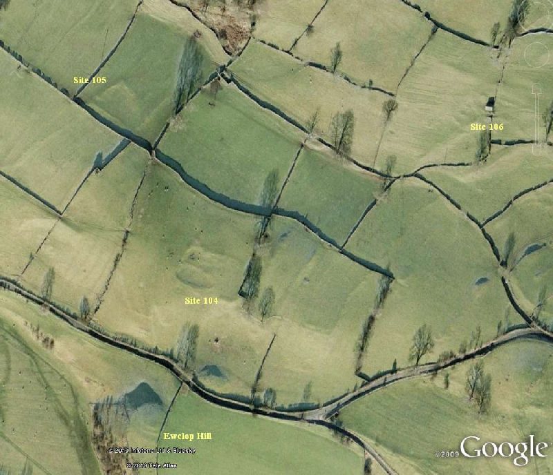
Figure 10: Google Earth view of Ewelop settlement
sites to the north of Ewelop Hill
|
|
Such scooped platform settlements are a
recognised and widespread settlement type throughout
Northern Britain, and are present elsewhere in Swaledale
with examples above Healaugh and at Low Whita (Fleming
1998).
A caveat on the dating of earthworks
from their morphology arises from the fact that the
enclosing ditch of a scooped rectangular settlement complex
earthwork at Gayles Lane, Hawes excavated by Percival
Turnbull was dated to the early medieval period (Turnbull
1986).
Settlement 100:
West Hagg Front Field. (Figures
11, 12 & 13)
Is an enclosed hill slope platform settlement comprising a
total of seven ovoid or circular platforms (100/01 to
100/07) within a narrow elongate triangular shaped enclosure
measuring some 50m by 25m. A further platform (100/08) is
located to the east of this enclosure.
|
|
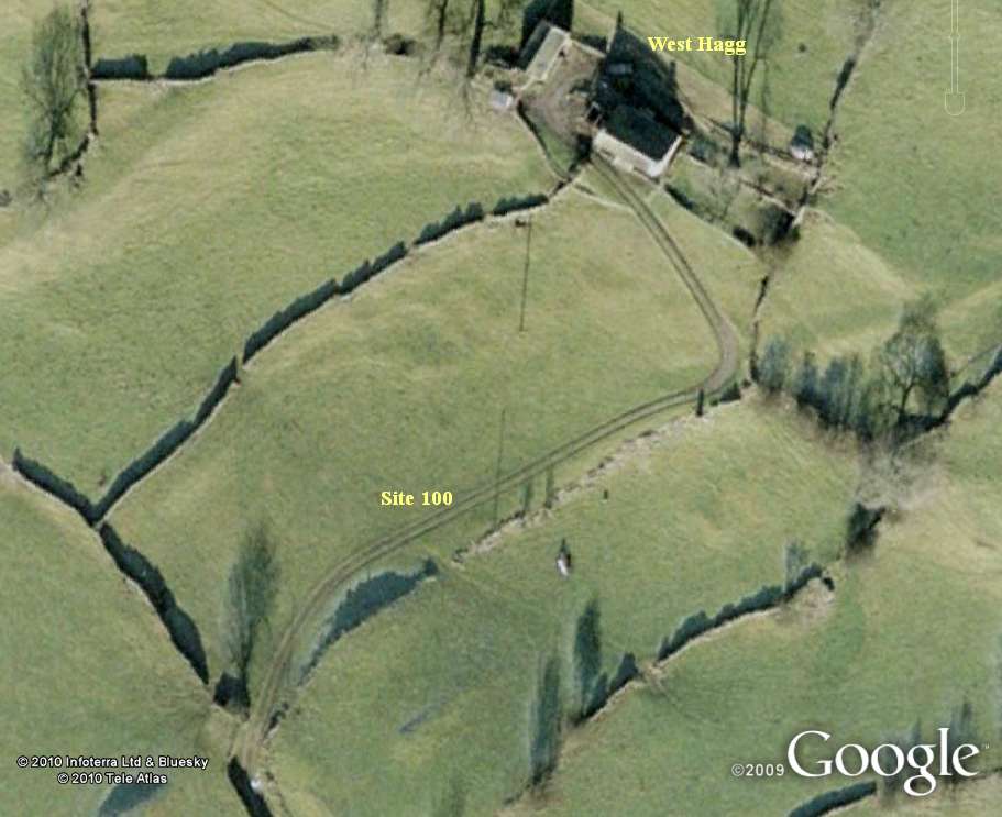
Figure 11: Google Earth
view of West Hagg Front Field Site 100.
|
|
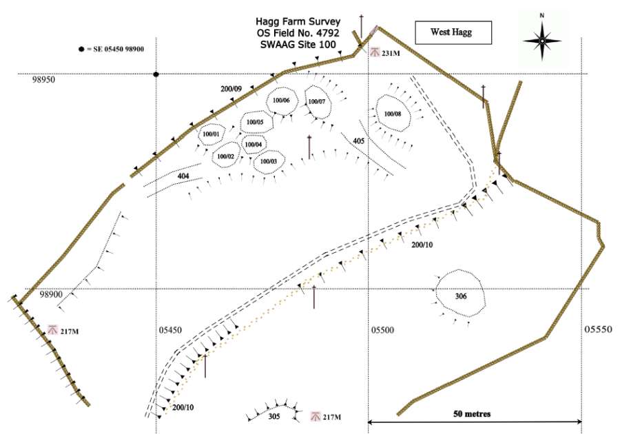
Figure 12: West Hagg Front Field Site
100 map.
|
|
The enclosure is approached from the
south and east by a narrow trackway and is bounded on the
west side by a substantial lynchet scarp, averaging 2m high,
surmounted by a modern field wall.
|
|
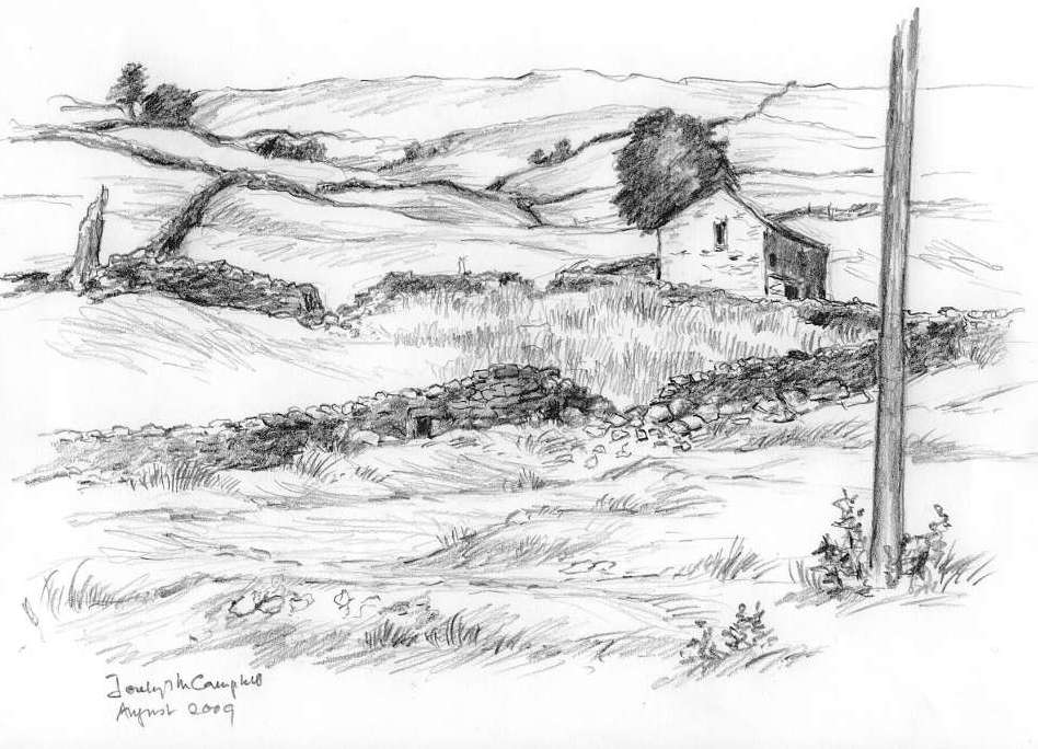
Figure 13: West Hagg Front Field Site
100 settlement platforms. Sketch: © Jocelyn Campbell 2009.
|
|
In situ and tumbled stone indicate that
this lynchet was probably originally stone faced as a
retaining wall. The enclosure is bounded on the lower
eastern side by a slight lynchet which indicates that this
less steep slope was cultivated right up to the edge of the
settlement.
Settlement 101:
The Barn Field Settlement. (Figures 14 to 17)
A hillside platform settlement comprising seven ovoid or
circular platforms (101/01 to 101/07), the largest of which
measures between 7m and 9m across.
|
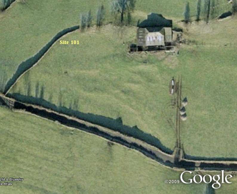
Figure 14: Barn Field Settlement Site
101.
|
|
They are set
within a triangular shaped enclosure defined by lynchetted
banks measuring some 80m at the base (aligned NW/SE) x 50m
(aligned N/S) x 60m (aligned E/W). Two further possible
small platforms (101/08 and 101/09) lie just outside and
abut the enclosure banks.
|
|
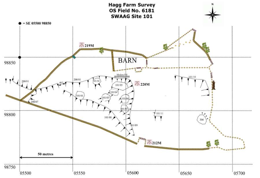
Figure 15: Barn Field Settlement Site 101
map.
|
|
The settlement was approached through small entrances
(gateways perhaps) marked by narrow gaps through the lower
boundary (404) and through two gaps at the western end,
(402, 403). The northern boundary extends below the modern
dry stone walled boundary of field OS 6181 in an
approximately westerly direction to form a key lateral
banked and lynchetted boundary (200/01) which links
settlements 100 and 101 to the contemporary field system
(200). Visible facing stones at 101/08 indicate the
lynchetted enclosure banks were originally revetted.
|
|
Figure 16: Barn Field
Settlement Platforms Site 101, Photo: R Carter 2009.
|
|
Possible
gateway (402) has a possible track leading in a southerly
direction which appears to continue southward in the
pastures on the far side of the Fremington to Marske road.
The settlement can be described as slightly scooped and
levelled into steeply rising ground. The relationship
between the settlement enclosure and the prominent earthwork
immediately to the rear of the modern barn buildings is not
understood. The northern corner of the settlement has been
obscured by fill from the recent extensions to the barn.
|
|
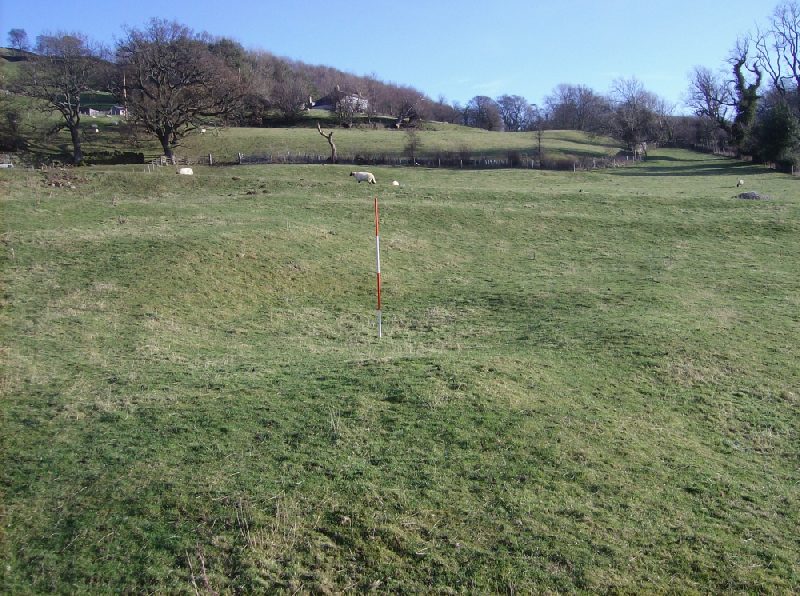
Figure 17: Barn Field
Settlement Platform Site 101/03, Photo: Tim Laurie 2009.
|
|
Settlement
101 is located at the head of a field system which extended
down towards the Swale floodplain across the Fremington to
Marske Road. The fact that the lower southern boundary of
the settlement was lynchetted indicates that cultivation of
these fields terminated at the edge of the settlement. Small
lynchetted features (101/10 and 101/11) and a reduced
clearance mound (304) are further evidence of cultivation to
the east of this settlement.
Settlement 102:
Hen House Settlement. (Figures 18 to 21)
Hillside platform
settlement comprising four ovoid or circular platforms
(102/01 to 102/04), the larger three of which measure
approximately 12m-15m across (102/03 is smaller at 8m).
Site 102/02 contains a modern wooden shed and Site 102/04 is
slighted and possibly truncated by a stone-shed built into
the hillslope on its northern side. These platforms are set
within a triangular shaped enclosure defined by a steep
natural slope to the north, lynchetted banks to the
north-east and south-east and the platform banks of
102/01-03 to the south-west. The enclosure measures 60m W/E
by 30m N/S. The lynchetted bank forming the south-west
boundary of the enclosure, and which appears to be slighted
by platform 102/04, appears to begin at the settlement and
continues north-eastwards on a SW/NE alignment as part of a
series of co-axial banks extending towards Reels Head.
|
|
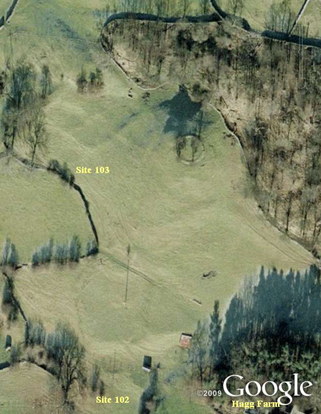
Figure 18: Google Earth view of
Settlement Sites 102 (Hen House) and 103 (Hagg Plantation).
|
|
The settlement is approached by a trackway (411) rising from
the south from lower ground (not surveyed). Two trackways
(also labelled 411) link platforms 102/02 and 102/4 to the
lower of two pronounced flattened shelves on the hillside
above, possibly “Celtic” fields (each roughly 25m x 25m)
which may have been artificially levelled but show no signs
of lyncheting activity.
|
|
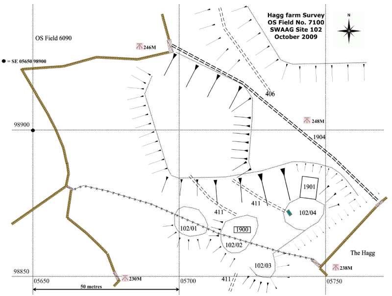
Figure 19: Hen House Settlement
Site 102 map.
|
|
A trackway
(406) traverses the uppermost of these fields from above
Site 102/04 towards Settlement Site 103 on the higher ground
to the north-west but does not directly abut Site 102,
possibly due to being slighted by a later, possibly modern
trackway (1904). The settlement can be described as slightly
scooped and levelled into steeply rising ground.
Trackway 411 rising from the south suggests that Settlement
102 may lie at the head of a field system which extended
down towards the Swale floodplain across the Fremington to
Marske Road.
|
|
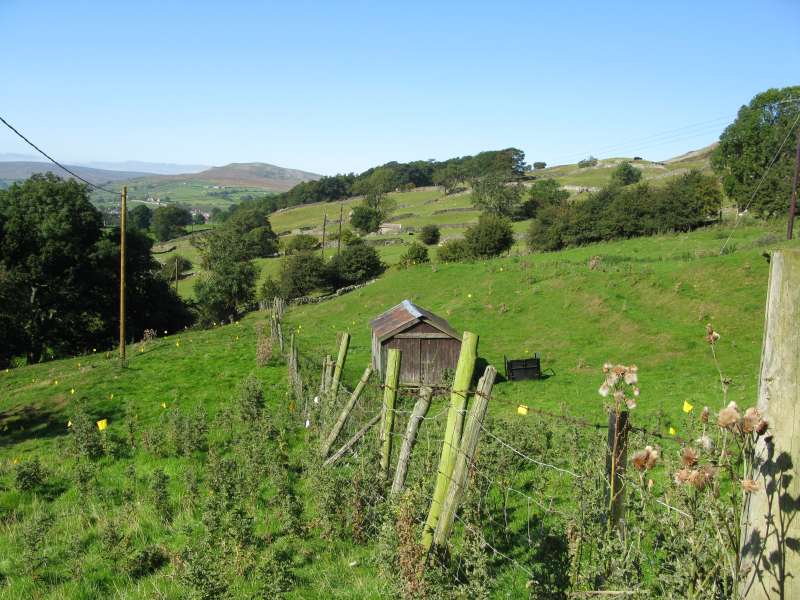
Figure 20: Hen House Settlement
Site 102. Photo: R Carter 2009
Platforms 102/01 and 102/02 cut by wire fence.
|
|
It also
appears to be linked to the two “Celtic” fields above, to
the larger Site 103 higher up the hillside to the
north-west, and to the SW/NE co-axial system to the east.
These relationships remain to be clarified and understood.
|
|
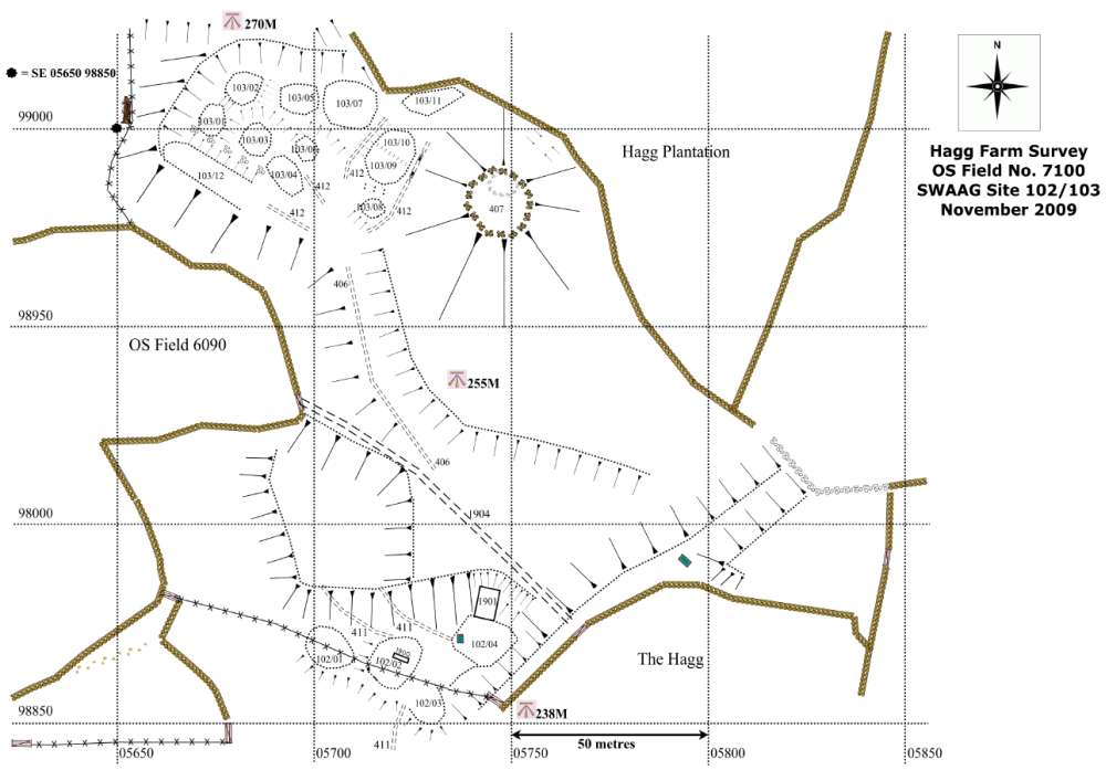
Figure 21: Settlement Sites:
102 and 103 map.
|
|
Settlement 103:
Hagg Plantation Settlement. (Figures 18, 21, 22, 23 & 24)
Enclosed hillslope
platform settlement comprising eleven ovoid or circular
platforms (103/01 to 103/11), of which four measure
approximately 10m to12m across and seven measure 5m to 8m
across.
A further
rectangular terrace like feature immediately below the
pronounced south-west lynchet measures approximately 20m x
7m. While labelled 103/12 in the settlement series this
feature could possibly be a levelled paddock. The settlement
is set on a natural saddle below steep hillsides to the
north, west and south-west and a prominent glacial mound
(407) some 15m high to the east. This mound has been
landscaped in the past, possibly in the nineteenth century
but there is no evidence as yet as to whether it has more
than a geomorphological relationship with the settlement.
|
|
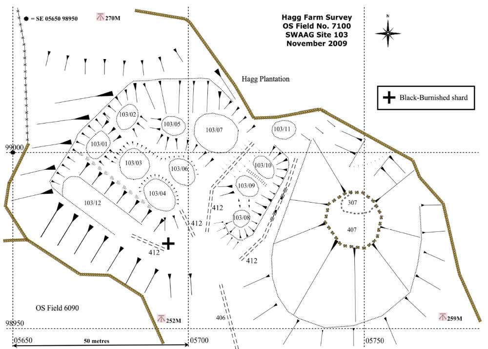
Figure 22: Hagg
Plantation Settlement Site 103 map.
|
|
The hillside
continues to fall away sharply to the south-west and south.
The settlement is scooped into the surrounding slopes within
a broadly trapezoidal enclosure and has a strong lynchetted
bank on its south-west edge which is visibly stone-wall
revetted for much of its length.
|
|
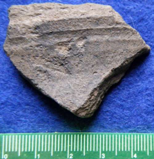
Figure 23: Hagg Plantation
Settlement Site103 sherd find. Photo: Tim Laurie 2010.
|
|
A pottery
sherd provisionally identified as BB2 Black Burnished ware
or a local copy was found in mole hill spoil on the lower
slope of this bank at SE05693 98976 suggesting possible
rubbish disposal from the settlement. Three further sherds
of possible Romano-British date await more positive
identification.
The
enclosure measures some 60m at the base (aligned NW/SE) by
50m (aligned NE/SW). The settlement was approached by a
trackway (406) rising to meet it from the direction of the
(smaller) Site 102 to the south. This trackway divides into
three branches (all labelled 412) within the settlement, one
branch leading to 103/12, one to the main body of the
settlement to the north-west (103/01-7) and one dividing
that main body from the three platforms scooped into the
side of the glacial mound to the east.
Settlement 103 is located in a commanding position above but
adjacent to the observable elements of co-axial field system
200 which extends to the west, south and east, with rising
broken ground above it. It is the largest of the settlement
sites in the survey area but has little easily cultivable
ground or significant pasture in the immediate vicinity,
apart from two sizeable “Celtic” fields downslope and closer
to the smaller Site 102
|
|
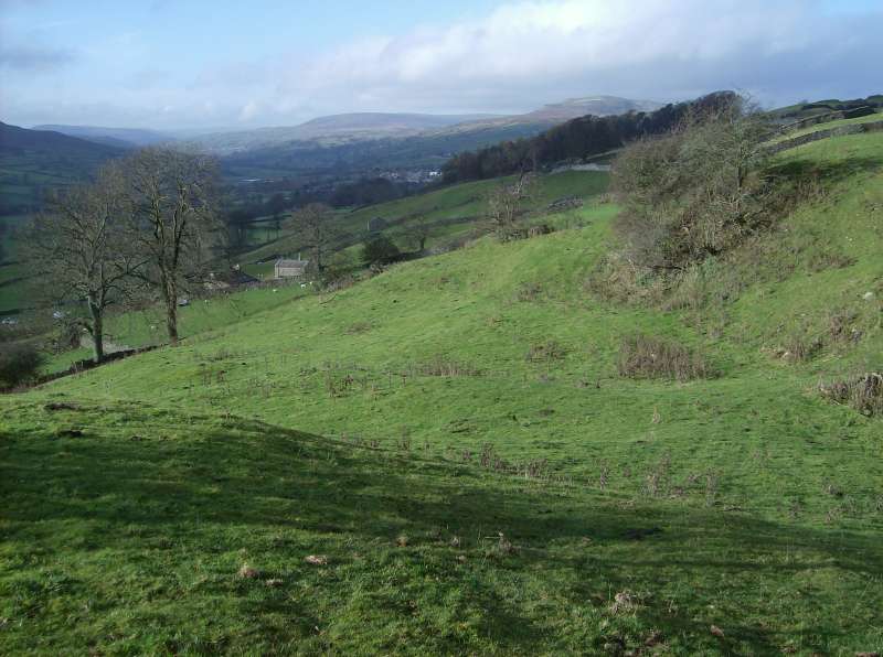
Figure 24: Hagg Plantation
Settlement Site103. Photo: Tim Laurie 2009
|
|
That said,
it clearly sits at the head of a field system which extended
down past Site 102 towards the Swale floodplain across the
Fremington to Marske Road. This survey has so far been
unable to clarify or understand the relationship with Site
102, the possibility that Site 103’s size and position might
imply some sort of primacy among the settlement sites in the
survey, or whether Site 103 relates to livestock management
or possibly lead mining activity in the broken ground and
open moorland above the site.
Settlement 104:
Ewelop Site 1. (Figures
25, 26 & 27)
This prominent homestead settlement which measures some 25m
x 25m overall is deeply recessed (scooped), for shelter,
into the upper slopes of a fluvio-glacial terrace
immediately north of Ewelop Hill.
(Note: Ewelop Hill is the remains of a terminal moraine
marking a pause phase in the retreat of the Swaledale Ice.
The very steep upstream Ice Contact Slope is clearly visible
below the road from Fremington (Raistrick, 1929).
|
|
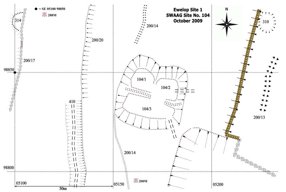
Figure 25: Ewelop 1: Settlement
Site104 map.
|
|
Two large house
platforms, measuring some 9m diameter are visible at the
back or northern side of the settlement. As is
characteristic of these scooped settlements, the two house
platforms are fronted by a lower stockyard. Scooped
homestead settlements on the fringes of the Cheviot Hills in
North Northumberland have been recorded showing evidence for
circular timber dwellings on terrace like platform
affronting a recessed stockyard, similar to Site 104. These
were considered by the late George Jobey (Jobey 1962) to
predate the enclosed curvilinear settlements of stone
founded round houses dated to the period of Roman
Occupation.
|
|
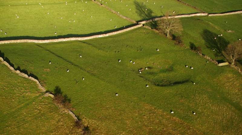
Figure 26: Ewelop 1 Settlement
Site 104. Photo: S. Eastmead 11/11/2009
|
|
Settlement 104 is
located within a contemporary field system in such a way as
to leave no doubt the field system and settlements are
contemporary (Figure 24). Field boundaries abut all
four corners of this settlement and a further boundary
approaches but stops short of the centre of the uphill
northern side.
|
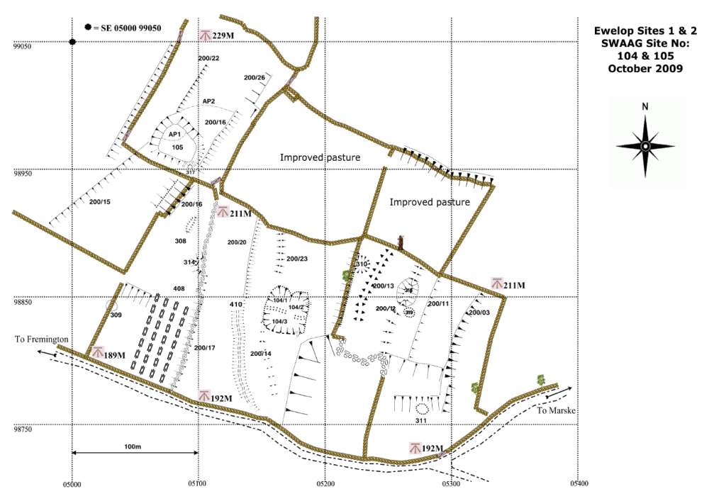
Figure 27: Ewelop 1 and Ewelop 2:
Settlements map showing sites 104 and 105 respectively
|
|
Settlement 105:
Ewelop Site 2. (Figures 27 & 28)
This settlement is located some 150m to the NW of Site 104
and is on more or less level ground at the front, southern
edge of the wide pasture/terrace below Intake Wood.
|
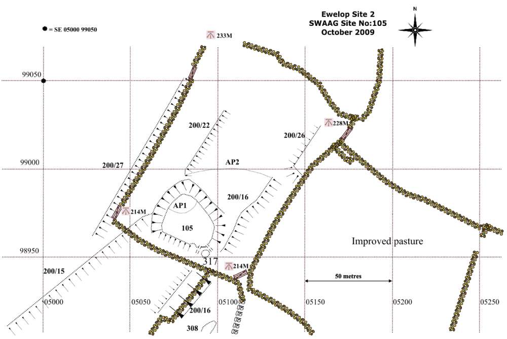
Figure 28: Ewelop 2: Settlement Site 105
map
|
|
This settlement (Figure
28) comprises a sub-rectangular leveled platform
measuring some 30m-50m overall and is defined on the
Northern side by a rear scarp and on the southern side by a
front apron. It is in effect a scooped settlement although
much less deeply recessed than is Site 104.
While no house
platforms are visible on the ground, the excellent Google
Images do indicate or hint of the presence of circular
buildings along the northern side of the settlement.
Most significantly,
field boundaries abut the SW, SE and NE corners of this
settlement in such a way as to leave no doubt that the
settlement is contemporary with Field System 200 (see also
Figures 2 and 3).
Settlement 106: West Hagg Western Field.
(Figures 29 & 30)
Hillside platform settlement comprising three ovoid or
circular platforms (106/01-03) set within an elongated
triangular-shaped enclosure measuring some 25m at the base
(aligned N/S) x 75m (aligned E/W) x 75m (aligned SSW/ENE)
defined by lynchetted banks steepening to the west. Site
106/1 is an elongated circular platform measuring roughly
25m x 20m and aligned NNW/SSE above a steep bank to the SW
and below the slight front bank of the enclosure to Site
106/2. The platform contains three faint possible hut sites.
Site 106/02 is slighted by a modern barn (1902) and
disturbed by activity generated by a gateway to the south
and the modern drystone wall which separates Fields 3600 and
4400, but can be seen as an elongated oval platform aligned
W/E measuring roughly 35m W/E and 15m N/S. It is backed by a
steep, possibly natural, bank and fronted by a small apron
bank above Site 106/01.
|
|
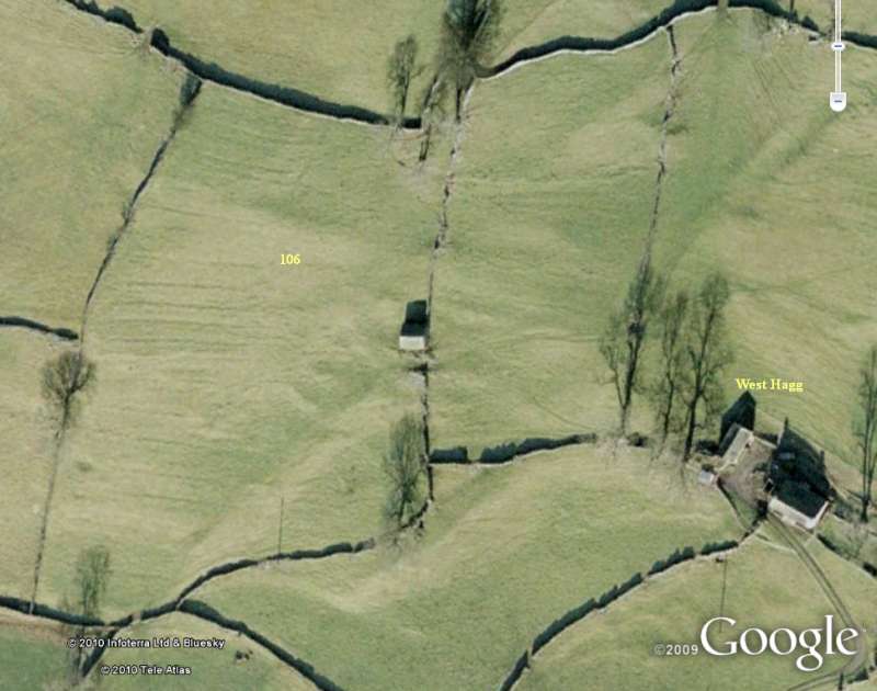
Figure 29: Google Earth view of West Hagg
Western Settlement Site106.
|
|
Site 106/03 is a circular platform
roughly 12m in diameter, sharing the same narrow shelf and
virtually contiguous with Site 106/02, with steep lynchets
above and below which it slights.
|
|
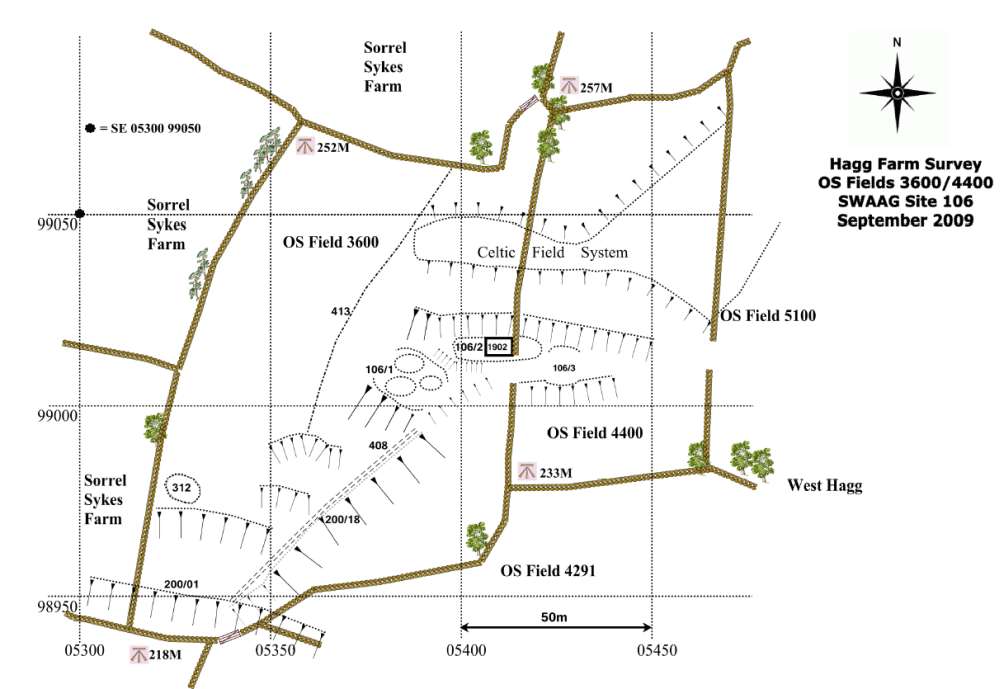
Figure 30: West Hagg Western
Settlement Site106 map.
|
|
Site 106 is approached from the SW by a
trackway (408) which runs uphill from the “master” lynchet
200/01 (which itself may be paralleled by an E/W trackway)
along the crest of lynchet 200/18 which is a significant
component of the SSW/NNE element of co-axial field system
200. The trackway ceases to be visible just below Site
106/01 and the lynchet fades to a barely visible feature
running to the NNE up to the terrace on which Sites 106/02
and 106/03 are located. It may re-appear more substantially
further uphill to the NNE in Field 4400.
Immediately to the N above Site 106,
and extending E, are two substantial terraces with the
appearance of some artificial levelling which may be
“Celtic” fields. The steep hillside to the W of Site 106 is
dissected by the remains of a wall or bank (413) running
SSW/ENE in parallel with the western drystone wall boundary
of Field 3600. This wall contains remains of a hawthorn
hedge. It has not yet been possible to clarify or understand
whether wall/bank 413 and the drystone wall represent relics
of the ancient co-axial field boundaries of stone and hedges
or of a medieval stone-breasted “quick” hedge boundary.
Settlement
107: West Hagg Eastern Field.
(Figure 31)
Hillside platform (107/01) is roughly semi-circular
and 15m in diameter fronted by a substantial lynchet and
backed by a drystone wall which revets higher ground above.
Some 20m below and to the south of the platform, is a
substantial curving lynchet with visible stone facing.
|
|
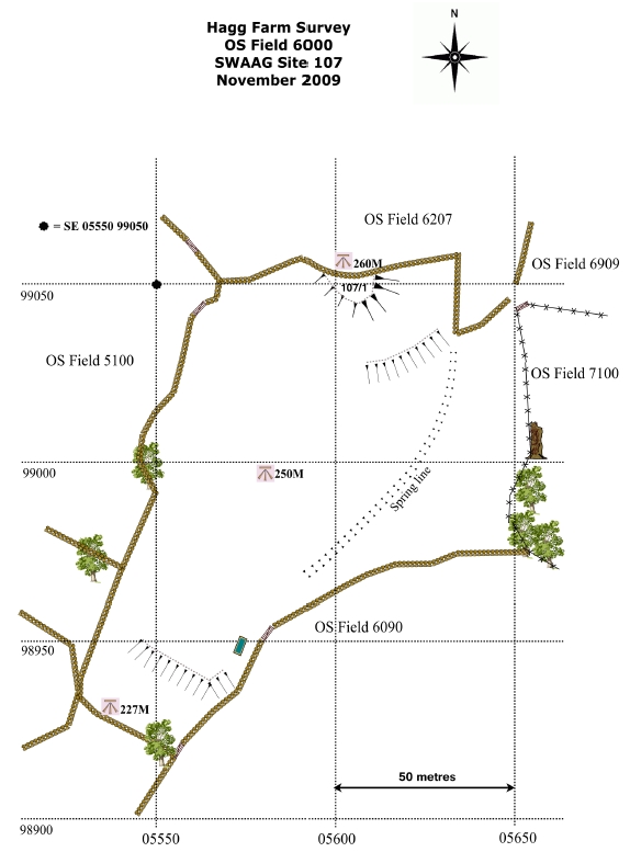
Figure 31: West Hagg Eastern Field
Settlement Site107 map.
|
|
Site 107/01 appears disturbed and may
have been infilled by stone waste from constructing the
drystone wall above.
There is no visible trackway dedicated
to the site. To its east, running N/S, is a substantial
spring in a shallow valley flanked to the E by a
drystone wall which revets the hillside to the E and
contains the remains of ancient trees and a thorn hedge. In
this valley is a substantial modern trackway leading to the
water-source. It is possible that this single platform,
107/01, provided the stance for an isolated round house
situated within its own fields.
Settlement
108: Upper Barn Field. (Figures 32, 33, 34 & 35)
Site 108/01 is approximately 25m in diameter,
levelled into the hillslope and enclosed by a visible bank.
This platform extends below the eastern field boundary wall
into the adjacent field where it has been slighted by recent
ploughing.
|
|
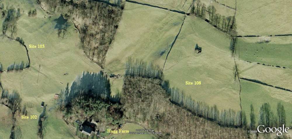
Figure 32: Google Earth
view of Upper Barn Field Settlement Site 108.
|
|
An ash tree grows on the northern edge.
The platform lies within the field system running SSW/ENE
towards Reels Head. (Figure 32)
|
|
Figure 33: Upper Barn Field
Settlement Site 108, Platform 108/1. Photo: Tim Laurie 2009.
|
|
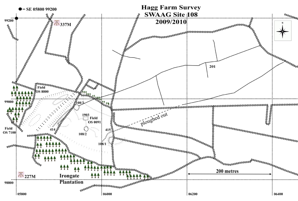
Figure 34: Upper Barn Field
Settlement Site 108 map.
|
|
The boundaries of this field system are
ploughed out in the immediate vicinity of the platform. The
boundary shown on our survey as a trackway (415), continued
down to the steep slope of the modern Irongate Plantation
below.
Site 108/02 is an isolated house
platform, circular in plan and approximately 10m in
diameter.
Site 108/03 is an isolated house
platform, circular in plan and approximately 12m in
diameter, filled with stones possibly dumped after dry-stone
walling. Trackway (414) rises to platform 108/03 from the
SSW, broadly from the direction of sites 102 and 103, after
running along the upper edge of the steep broken valley
which flanks Site 108/03.
|
|
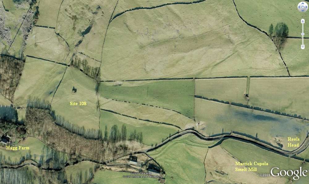
Figure 35: Google Earth view of Upper
Barn Field Settlement Site 108 and associated coaxial field
system.
|
|
A second coaxial boundary (201/2)
running SW/NE towards Reels Head, terminates on Site 108/03
and on the edge of the steep valley. Slight apparently
natural terracing adjacent to the three platforms represents
small scale cultivation in Upper Barn Field, contemporary
with the platform settlement.
6 Field Systems (Figures
36 to 42)
Two areas of co-axial fields (200 and
201) were identified by the survey sharing the same general
WSW-ENE co-axial alignment, the lower of these being linked
by the strong lynchet 200/01 to the settlements in the West
Hagg pastures. (Figures 36, 37 & 38)
|
|
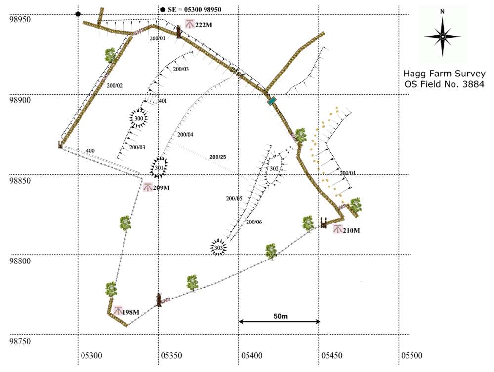
Figure 36: Hagg Farm OS
Field 3884 map (located below Site 100) Showing lynchet
200/01
|
|

Figure 37: Hagg Farm field 3884: lynchet 200/01 with
mound 302 in the background Photo: Tim Laurie
|
|

Figure 38: Hagg Farm OS
Field 4291 map (between Site 100 and Site 106) also showing
lynchet 200/01
|
|
The upper area is located on rising
ground north west of the road crossing Reels Head. This
upper field system, Field System 201, is likely to be
contemporary with the lower system. No association has been
demonstrated between these field systems on The Hagg Farm
pastures and the Marrick Moor Field System, which is a
complex landscape of Bronze Age affinities on the high
moorland of Copperthwaite Allotment, above and immediately
below Fremington Edge (Figure 39).
This Bronze Age field system comprises
unenclosed settlements, cairnfields and the very large
coaxial field system which extends from Fremington Edge
across Copperthwaite Allotment to cross the Hurst Road at
Stelling.
|
|
Figure 39: Fremington Edge with
Copperthwaite lead vein (foreground) and Copperthwaite Allotment
beyond.
Photo: S. Eastmead 11/11/2009
|
|
Excavation of an enclosure thought to
be a round house and seemingly attached to one of the
coaxial boundaries at Reels Head showed the enclosure to be
a medieval sheepfold which overlies the early field boundary
which had been reused during a later period (Fleming and
Laurie, SWALB Interim Report No 2 for 1985).
The ancient field systems in the Hagg
Farm pastures are visible today as substantial lynchetted
boundaries 0.5m-3m high -steep short scarps cut into the
natural hill side formed by cultivation against a boundary
on sloping ground and natural slopes which have been
over-steepened by cultivation.
All natural terraces show signs of
artificially levelled areas which were presumably
cultivated. Significantly few areas show evidence for
medieval rig and furrow. More recent dry-stone walls often
overlie or have been built immediately above the lynchets
which mark ancient field boundaries.
The EDAS survey suggested that over one-third of Hagg Farm
walls, particularly around West Hagg, appear to be
medieval/post-medieval rather than dating from 18th
century enclosure. Many of these older walls utilize the
pre-existing field settlement boundaries, suggesting an
interesting case study in the interaction between categories
of relict and historic landscape types, as utilized in the
field of ‘Historic Landscape Characterization and Analysis’
(Rippon). The settlement sites appear related to and
lie within the co-axial fields.
|
|
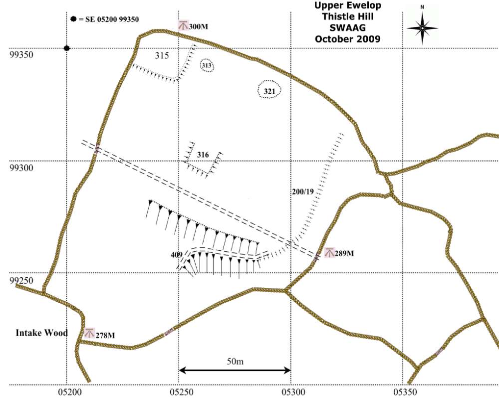
Figure 40: Ewelop
Thistle Hill map. (Located above Ewelop 2: Site 105 with
Intake Wood in-between)
|
|
Field System 200
(Figures 2 & 3)
This coaxial field system (with field boundaries
which share a common axis, i.e. are parallel) extends across
the pastures of West Hagg and Sorrel Sykes Farms reaching an
elevation of 275m OD, and across the road from Fremington to
Marske into the pastures immediately above the Swale flood
plain. This field system is defined by very substantial
stone embanked and lynchetted boundaries (200/01 – 200/27)
on the best, more level, cultivated land and by
over-steepened edges formed by ploughing to the rear and
front edges of natural terraces on hill slopes. The lynchets
and stone banks probably contain faced stone walls,
originally hedge banks or retaining walls. This field system
is directly associated with the platform settlements
previously described (Sites 100-108).
The best analogue for the West Hagg and
Sorrel Sykes coaxial field system is the planned coaxial
field systems defined by strong banks and lynchets
associated with Late Iron Age settlements above and east of
Healaugh which were surveyed and selectively excavated
during the Swaledale Ancient Land Boundaries Project
(Fleming and Laurie, SWALB Interim Reports Numbers 5–7,
1988-1990 and Fleming, Chapter Nine).
At Healaugh, very strong lynchets run
directly down slope towards the Swale flood plain from the
series of prominent platform settlements located within the
walled pastures. These lynchets are evidence for the arable
cultivation of the very steep hillside east of Healaugh over
a very lengthy period of time. The fact that the fields
bounded by deep lynchets run down slope is strange, since
cultivation of these steep slopes must have been very
difficult and terracing would have been much more efficient.
All the above descriptive comments
could apply to the coaxial field system at West Hagg and
Sorrel Sikes.
The evidence for the association
between the coaxial boundaries of Field System 200 and the
scooped platform settlements 100-108 is summarised below:
- Field banks 200/15 and 200/16
originate from the corners of Settlement Site 104.
- Field bank 200/14 is aligned on
and forms the western edge of Settlement Site 105.
- Lateral boundary 200/01 is the
western continuation of the lynchet forming the upper,
northern edge of the Barn Field Settlement enclosure
Site 101.
- Lateral boundary 200/01 extends
westward from Site 101 to form the prominent scarp at
the West Hagg Farm track entrance gates, then continues
as the strong lynchet directly below the modern field
wall between fields 4792 and 3884. This lynchet is the
dominant structural element of Field system 200 forming
the terminus of all banks and images crossing Field 3884
including features 200/02/03/04/05/06; and those
crossing Field 4792 including lynchets 200/09 and
200/10. Lynchet 200/09 forms the western side of
Settlement 100.
- The oversteepened slope 200/18 and
those forming the sides of Settlement Site 106 also
terminate on lynchet 200/01.
Evidence for late reoccupation of Field System 200.
Whereas the framework for field system 200 is
associated with and therefore contemporary with Settlements
100-108, there is no doubt that these fields, established
during the Iron Age, were reoccupied intermittently and the
boundaries of this field system were recognised throughout
subsequent periods.
Presumably this subsequent cultivation
increased the depth of the original lynchets and added to
the dimensions of the substantial clearance mounds, Sites
300-321.
Occasional very slight late lynchets
run to the side of the main phase lynchets e.g. Features
200/02, 200/04, and 200/05 which are just 0.4m high. These
slight lynchets probably represent reoccupation during
periods of arable land expansion, e.g. for the ‘Dig for
Britain’ campaigns during the two World Wars.
Boundary 200/01 (Figures 36 to 38)
Lateral boundary 200/01 is the western continuation of the
lynchet forming the upper, northern edge of the Barn Field
Settlement enclosure Site 101.
This boundary extends westward from
Site 101 to form the prominent scarp at the West Hagg Farm
track entrance gates, and then continues as the strong
lynchet directly below the modern field wall between fields
4792 and 3884. This lynchet is the dominant structural
element of Field System 200 forming the terminus of all
banks and lynchets crossing Field 3884 including features
200/02/03/04/05/06, and those crossing Field 4792 including
lynchets 200/09 and 200/10. Lynchet 200/09 forms the western
side of Settlement 100. The gap through 200/01 for the
entrance track to West Hagg Farm House has probably always
been an access point, for example from the lower fields to
Settlement 100.
Field System 201 (Figures 2, 4, 34 & 35)
This field system also appears to have been associated with
the Hagg Farm settlements on grounds that the boundaries are
aligned on The Hagg. The field system has been slighted by
improved pasture below Reels Head and is incomplete.
Elements which survive comprise three coaxial field
boundaries sharing the same SW/NE axis with lateral
subdivisions, together with an enclosure and several small
cairns.
The structure at
Reels Head excavated during the SWALB Project
(Fleming and Laurie, SWALB Interim Report No 2, 1985)
proved to be a medieval sheepfold
overlying the earlier coaxial field boundary.
The Marrick Moor
Field System (Figure 41)
The Marrick Moor Field System together with the
cairnfield-type settlements of Bronze Age character on
Fremington Edge and on the lower moorland south of Owlands
Farm was surveyed with EDM Theodolite during the SWALB
Project and an outline plan was produced (Fleming and
Laurie, Interim Report No 2, 1985 Season, Figure 1). This
outline plan was intended to show the extent of the coaxial
field systems on Copperthwaite Allotment together with that
further east on Skelton Moor which shares the same axis. The
detailed SWALB survey of Marrick Moor shown below with
additional detail (Fig. 41) has however been unpublished
hitherto (Laurie, Mahaffey and White, forthcoming).
|
|
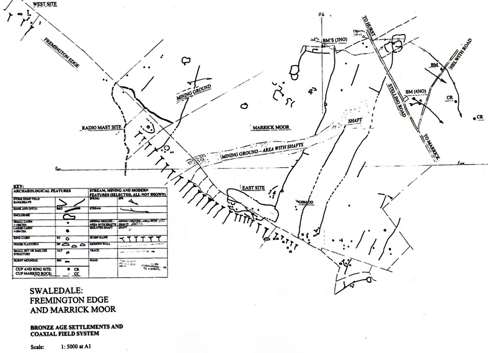
Figure 41: Marrick Moor
Coaxial Field System.
Map: Tim Laurie (1985) Thanks to the landowner Mr.
Bainbridge (1985)
|
|
The Marrick Moor
field system is defined by long field boundaries which are
substantial stone banks, highly consolidated and usually
shrouded under heather. These field boundaries are up to 2km
in length and parallel (i.e. coaxial) to one degree of
compass bearing.
This coaxial field
system together with the associated settlements, rock art
and a total of 9 burnt mounds can be seen to be a fossil
Bronze Age Landscape, generally above 400m OD and, since the
Marrick Moor and Skelton Moor field systems share the same
NNE-SSW axis, extending from Fremington Edge to Munn End
above Telfit Farm - a total area of 9 sq. km.
Three cairnfield
settlement complexes, comprising stone banked enclosures,
small cairns, and ring cairns which are now regarded as
isolated round houses, have been recognized on Fremington
Edge at situations which are today highly exposed but which
may have been sheltered by woodland during the Bronze Age (Figure
39) and, together with an additional site beyond
Fremington Edge, are briefly described below:
Fremington Edge
East Site
This settlement complex which
comprises a large ovoid stone banked enclosure with small
cairns, possible round house enclosures and fragmentary
field banks is centred on a large round cairn at SE05444,
99644, 419m OD. No less than three field banks converge on
the cairn. This round cairn is located in pasture just 20m
south of the modern stone wall and track which runs the
length of Fremington Edge. The cairn has been severely
quarried for the adjacent wall, but the perimeter of the
cairn survives. Most significantly, a long field bank, an
element in the coaxial field system which crosses Marrick
Moor and Skelton Moor, abuts but does not cross this
enclosure. This fact provides critical dating evidence that
the Bronze Age Settlement complex is contemporary with or
formed the settlement core associated with the construction
of the coaxial field system, which respects the enclosure.
Fremington Edge
- Radio Mast Site.
This settlement is located in
pasture above Fremington Edge in the vicinity of the rusting
remains of an old radio mast at NZ0470, 0030, 410m OD. The
settlement comprises a large ovoid enclosure partly shrouded
under peat within which is located a circular round house.
To the east of the radio mast are several cairns and a
second circular enclosure. The most westerly boundary of the
coaxial field system runs to the edge of the escarpment a
few metres to the south east of the Radio Mast. (Figures
41 & 42)
|
|

Figure 42: Fremington Edge
Radio Mast Site, coaxial field boundary. Photo: Tim Laurie
|
|
Fremington Edge
West Site.
This settlement is located in
pasture on the very edge of the escarpment above Castle
Farm, at NZ0370,012, 450m OD. The settlement comprises one
and possibly two round houses with field walling and small
cairns.
Settlements on
moorland South of Owlands Farm and north of the Hurst Road
at Stelling.
Six circular stone banked
enclosures each with enclosed round houses are located on
rising moorland on both sides of Raygill, and in pasture at
Stelling, north of the road to Hurst (Figures 5 & 41).
All the settlement enclosures described above probably
represent the summer encampments of seasonal pastoralists,
small pioneering family groups who may have moved with their
animals from their year round settlements on the gravel
terraces of the Swale and Wharfe in the Vale of Mowbray
(Figure 48), to take
advantage of the grazing available on the limestone of the
Pennine Dale Fringe. The coaxial field system which
developed from these pioneering settlement cores extends
across the open heather moorland on Copperthwaite Allotment.
One coaxial field boundary crosses the Marrick to Hurst Road
to a settlement with two round houses located in the modern
walled pastures at Stelling.
Burnt Mounds at
Stelling Springs.
Burnt mounds are crescentic
mounds of highly-compacted fire cracked sandstone fragments:
discard heaps arising from the heating of water with hot
stones. These mounds are generally 8m to 18m in diameter and
are always located at springs or on the edge of low energy
streams below springs. The majority of burnt mounds have
been radiocarbon dated to the middle Bronze Age with a few
sites dating to the Late Neolithic, and are now generally
described as being sweathouses/saunas, although many uses
have been proposed including cooking, fulling woollen cloth
and brewing, and other uses are possible. No less than nine
burnt mounds are located at springs rising on the lower
moorland slopes south of Owlands Farm and at Stelling
(Laurie 2004 and Figure 41). The largest of these is
south of Raygill, at NZ05457, 00530. A full gazetteer of the
burnt mounds on Copperthwaite Allotment and at Stelling
Springs is under preparation and will be attached as a
future Appendix to this Report.
Rock Art
A number of impressive rock
art sites have been located at Stelling, near Dales Beck and
on Skelton Moor in Marske Parish. (Beckensall and Laurie
1998). Representative selections of carved rocks are shown
below (Figures 43-45).
Two
carved rocks are located close to Dales Beck. A photograph
of one of these taken in October 2006 when the greater part
of the rock was covered under turf is included here as
Figure 43. This rock located on open moorland on Forty
Acres Allotment has recently featured in Current Archaeology
(CA 241, April 2010, pp 8-9.), when the remarkable detail on
the rock was revealed following removal of the partial turf
covering.
|
|
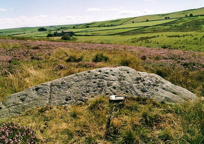
Figure 43: Dales Beck Rock
Art. Photo: Tim Laurie 2006 |
|
|
|
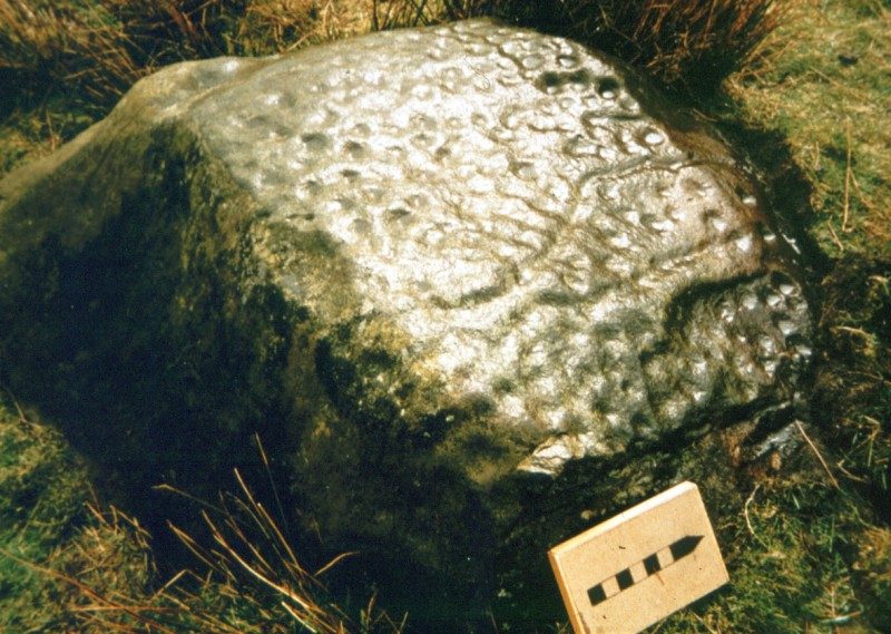
Figure 44: Cock How Rock
Art. Photo: Tim Laurie 1984 |
| |
|
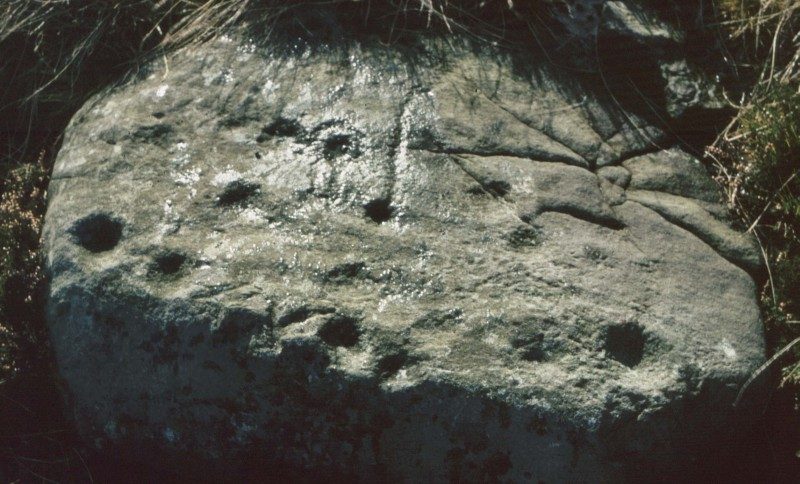
Figure 45: Marske Munn End
Rock Art. Photo: Tim Laurie 1984
|
|
7. Other
Features
Trees and Hedges
Trees and hedges in this study
area will be the subject of a separate report. It is
increasingly recognized that ancient trees and hedgerows may
preserve aspects of early landscape boundaries which are
otherwise obscured by later developments, or that their
presence along the line of later boundaries indicates that
such boundaries respect their predecessors. While no
individual tree or bush may date to the earliest boundary,
self-seeding and regeneration may well preserve a boundary
line predating all current markers. That said, some trees
present in the survey area, notably the elm pollards
(Fleming 1998) may well take us back to the mediaeval or
early modern landscape, as would hedgerows if the rule of
thumb that the number of species in an ancient hedgerow
reflects its age in centuries is correct. Trees and hedgerow
fragments incorporated in the more recent boundary landscape
of dry-stone walls suggest that such boundaries are
respecting much older hedge lines.
Mounds
Most mounds found within the survey area have the appearance
of field clearance mounds. No definite evidence exists for
burial mounds (barrow mounds) at Hagg Farm. However the
prominent knoll next to the road, south of The Hagg Farm
House, may prove to be an artificial barrow mound.
|
|
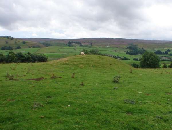
Figure 46: Hagg Farm OS Field 3884
site 302. Photo: S. Eastmead
|
|
Trackways/Pathways
Trackways, usually in the form of narrow hollow
ways, were present associated with and within the
settlements.
Other
finds
Two beehive quernstones have been located within
the survey area (Figure 47). The EDAS survey recorded
a quern stone base lying at the foot of a dry-stone wall to
the south-east of the small field barn at SE 0544 9897 west
of West Hagg. It is now better protected and is united with
an upper quern stone in the garden of West Hagg House (at
the time of the EDAS survey this was a private house and
outside the remit of the survey).
The two stones match reasonably well,
and in size, shape and state of preservation fall well
within the recorded database for North Yorkshire (Heslop
2008). As querns are unlikely to have travelled far from
their place of ownership and use, this is prima facie
evidence of Iron Age habitation in the survey area.
A sherd of Romano-British pottery (Figure
23), provisionally identified as BB2 Black Burnished
Ware or a local copy, was found in mole-hill spoil below
Site 103/04. Further sherds await identification.
|
|
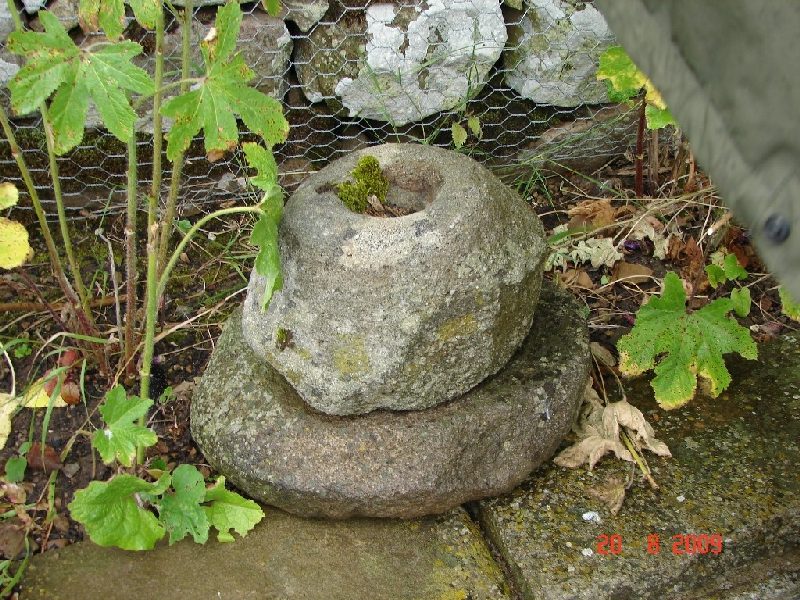
Figure 47: West Hagg garden – Bee Hive Quern.
Photo: S Eastmead 20/08/2009
|
|
8.
Discussion and Interim Conclusions
Our knowledge and
interpretation of late prehistoric/Romano-British settlement
in the Yorkshire Dales is far removed from the assessment,
pioneering and well-informed for the time, of Raistrick who,
focussing on West Yorkshire but generalizing to include the
northern dales, commented that “in this cold, wet climate
life must have been hard and the standard of living low” and
that for the Roman and post-Roman period the people of the
dales “chose freedom with poverty on the high ground” (Raistrick
1962). As recently as 1978, the definitive history of
Swaledale could conclude that “the most significant fact
about the pre-history of Swaledale is the paucity of sites
compared with other parts of the Pennines further north and
further south” and that Swaledale was not heavily populated
in prehistory (Fieldhouse and Jennings).
The work of Laurie and others has
revolutionized this picture, for Wensleydale, Swaledale,
Teesdale and the dales region. In Swaledale and at West Hagg
in the Iron Age/Romano-British period, we now see a
well-populated farming landscape, with substantial
unenclosed farmsteads in a linear pattern along the dale
sides in well-articulated field systems extending well
beyond present limits of cultivation and pasture. In
particular, this was an organized landscape delimited by
extensive co-axial field systems which in turn lie adjacent
to (and may in some cases overly) earlier Bronze Age
organized landscapes. Swaledale now ranks well with other
upland areas of England, for the Bronze Age, Iron Age and
the Romano-British periods, where upland areas are in any
case rather better represented than the lowlands in the
landscape record (Taylor). Indeed, for the Yorkshire dales
area, the density of settlement is exceptional and bears
comparison with Wharfedale and Grassington.
While it is not yet possible to
understand elements of continuity and discontinuity between
the Bronze and Iron Ages, some attempt at explanation of
this density of settlement is required, not least because
Swaledale is, ostensibly, a cul-de-sac rather than a main
route through the Pennines. Two factors merit
consideration:
- The geology of Swaledale offers
exposed limestone strata with strong springs issuing
from the base of each stratum, giving rise in
pre-history to species-rich hazel-dominant woodland
highly suitable for browse pasture and easy to clear for
more open pasture and cultivation: in sharp contrast to
areas where chert and sandstone dominate with poorly
drained soils, where field systems are absent. This
environment was probably first exploited through
seasonal occupation of the dale by population groups
resident year-round in the Vale of Mowbray. (Figure:
48)
- By contrast with wooded and marshy
valley bottoms in pre-history, the Swale-Tees-Greta
uplands provided easy access for the foot-traveller on
the SE/NW route from the Vale of Mowbray through
Stainmore and the Eden Valley to the Solway lowlands,
Galloway and Ireland
|
|
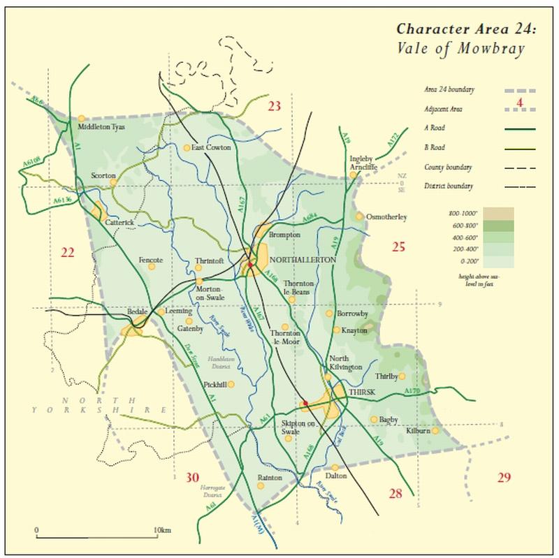
Figure 48:
Vale of Mowbray ©Natural England copyright 2010
|
|
For the Iron Age/Romano-British period
it is legitimate to speculate, as a guide for future work,
on the people who created this landscape and lived and
worked in it, and on the sort of activities they were
engaged in.
We can be reasonably sure that the
inhabitants of West Hagg spoke a dialect of P-Celtic and
belonged to what is now seen as a tribal confederation that
we know as the Brigantes, a name known through documentary
evidence from Roman sources and co-ordinated for the tribes
or peoples of Britain by Ptolemy in the second century C.E.
(Strang). We do not know what they called either themselves
or the area in which they lived. The extensive nature of the
co-axial field systems here suggests a form of hierarchical
social organization. At West Hagg we may therefore be
looking at tenant or otherwise subservient farmers owing
allegiance to an organizing elite based elsewhere. Evidence
of such an elite is sparse in Swaledale, apart from the
significant settlements at Applegarth and at Maiden Castle
on Harkerside (RCHME, 1996), the smaller hillfort at How
Hill, Downholme, and defended hill-top enclosures at Grinton
and How Hill, Low Whita (White, 2005). But Swaledale could
well have constituted lands belonging to members of the
Brigantian elite based in the lowlands to the east in the
Vale of Mowbray, or even at the major centre at Stanwick
close-by to the north-east. Only excavation might enable us
to date the farmsteads at West Hagg more precisely: for
example whether they are co-terminous with each other or
represent, for whatever reason, locational change over time
either through movement from one site to another or through
increasingly intensive settlement. Similarly, without
further investigation we can only speculate on whether and
how Swaledale was integrated into the Roman economy of
Britain. Was this predominantly a subsistence economy, as
White (op. cit.) has suggested for the dales region, or was
a site like West Hagg involved in surplus production either
for the Brigantian elite or for the Roman authorities or
both? The co-axial field system could suggest a regime
designed to produce surpluses for use elsewhere. Once the
Romans arrived, new demand was created, for food for their
mining camps, towns, forts and campaigning armies, and for
supplies such as hides and wool. Recent study of the
textile industries of Roman Britain has suggested that the
demand from the army in Britain at its peak under Hadrian
for finished woollen goods could have absorbed 200,000
fleeces annually and that perhaps half the rural households
in Britain were involved in production, especially in the
military zones (Wild). While it is suggested that raw wool
was rarely traded (everywhere had sheep), finished products
were traded internationally, and Diocletian’s Edict on
Prices of 301 C.E. lists the birrhus britannicus (a hooded
woollen cloak in widespread demand) as the sixth most
expensive out of 14 cloaks listed, and two forms of British
tapete (a woollen cloth or rug suitable for the saddle or
the couch) as the most valuable in their category.
Equally we cannot tell whether arable
land was significant in the landscape, although it is
reasonable to suggest that some cereals and vegetables were
produced on site.
It is also reasonable to assume that
the pastoral economy was focussed on sheep, probably similar
to the surviving Soay breed and to suggest that the co-axial
field systems delimit sheep-runs. During the Roman period,
the sheep:cattle ratio changed over time with an increase in
cattle numbers compared to the native British pattern
(Cool), but we cannot at present estimate the importance of
cattle here.
Next
Steps
Surveying of adjacent areas around the current
focus of this report will help to delimit the full extent of
the surveyed field systems and settlements and place them
within the broader context of the prehistoric landscape of
Swaledale. In particular, more work on higher ground to the
north of the current survey area, particularly around large
platforms visible in bracken above the headwall, could help
to elucidate continuity of settlement on the broader site
over time.
More detailed focus on trackways could
help to indicate how settlements in general were
inter-related, whether the main communications routes were
linear along the valley sides, whether there were links to
the river bottom in this period, and whether there were
links to possible early mining activity below and above the
main escarpment of Fremington Edge and possible settlement
(on present evidence earlier, probably Bronze Age) on high
ground above Fremington Edge at Copperthwaite Allotment.
Only intrusive excavation offers the
prospect of more precise dating within the broad time-frame
of Iron Age/ Romano-British dating, and thus of attempting
to understand how the evidence identified in this survey
relates to the broader issue of whether and how the rural
economy of Swaledale was affected by and responded to the
Roman occupation of North Yorkshire.
Acknowledgments
The
authors are delighted to dedicate SWAAG Archaeological
Report No. 1 to Helen Bainbridge of the Swaledale Museum in
appreciation of her contribution to the cultural life of
Swaledale and Arkengarthdale, and of her unfailing
professionalism and enthusiasm in supporting all who delve
into the history of our dales.
The authors wish to thank Mrs
Mary Clarke for her kind permission to access her land at
The Hagg; Martin Wood-Weatherall and Ronnie Bailey for
access at Sorrel Sykes farm; FPW for generously enabling
SWAAG to obtain aerial photographs; the indefatigable
Jocelyn Campbell for her splendid sketches; Ric Carter for
his photographs, and to all members of SWAAG for their
contributions to this work and for their enthusiasm, good
humour and support.
Copyright

The Fremington Project: An Iron Age/Romano-British Landscape at Hagg Farm by Swaledale and Arkengarthdale Archaeology Group is licensed under a Creative Commons Attribution-NonCommercial-NoDerivs 3.0 Unported License.
Based on a work at www.swaag.org.
|
|
Appendices
Appendix 1. Site and Feature
Numbers
Sites and features were, and future records will
be, assigned number sequences as follows (beginning with 100
to avoid confusion with EDAS feature numbers which ran from
1-94):
100-199 Settlements
200-299 Field systems
300-399 Mounds (Stone clearance mounds and cairns)
400-499 Miscellaneous secondary features (Trackways, gaps,
gateways in early field boundaries, field enclosures &
sheepfolds)
500-599 Burial & ritual sites (including: round barrows,
stone cairns, ring cairns, standing stones, & stone rings)
600-699 Rock art
700-799 Burnt mounds
800-899 Lithic finds and Occupation Sites
900-999 Midden sites
1000-1099 Artefact finds
1100-1199 Medieval settlements and isolated rectangular
buildings
1200-1299 Mining remains
1900-1999 Modern structures on / near archaeology
2000-2099 Topographical and geological features
2100-2199 Veteran trees and hedgerow fragments
Sub-numbers e.g. 100/01 are used to identify features within
a primary category.
| Settlements:
100+ |
|
Number
|
Field Number
|
Comments
|
|
100
|
4792
|
West Hagg
Lower Settlement
|
|
101
|
6181
|
Barn Field Settlement
|
|
102
|
7100
|
Hen House Settlement
|
|
103
|
7100
|
Hagg Plantation Settlement
|
|
104
|
|
Ewelop Site 1
|
|
105
|
|
Ewelop Site 2
|
|
106
|
4291
|
West Hagg
Western Settlement
|
|
107
|
6000
|
West Hagg
Eastern Settlement
|
|
108
|
0091
|
Upper Barn Field Settlement
|
| |
|
|
|
Field Systems: 200+
|
|
Number
|
Field Number
|
Comments
|
|
200/01
|
Several
|
Fields: 3600, 4291, 3884,
4792, 6090, 6181
|
|
200/02
|
3884
|
|
|
200/03
|
3884
|
|
|
200/04
|
3884
|
|
|
200/05
|
3884
|
|
|
200/06
|
3884
|
|
|
200/07
|
6181
|
|
|
200/08
|
4291
|
|
|
200/09
|
4291
|
4291, 4792
|
|
200/10
|
4792
|
|
|
200/11
|
Ewelop
|
|
|
200/12
|
Ewelop
|
|
|
200/13
|
Ewelop
|
|
|
200/14
|
Ewelop
|
|
|
200/15
|
Ewelop
|
|
|
200/16
|
Ewelop
|
|
|
200/17
|
Ewelop
|
|
|
200/18
|
3600
|
|
|
200/19
|
Ewelop Thistle Hill
|
|
|
200/20
|
Ewelop
|
|
|
200/21
|
0091
|
|
|
201
|
|
Reels Head field System
|
|
|
|
|
|
Mounds: 300+ Stone
clearance mounds and
cairns
|
|
Number
|
Field Number
|
Comments
|
|
300
|
3884
|
Indistinct Clearance Mound
|
|
301
|
3884
|
Clearance Mound / Possible
Post Mill site
|
|
302
|
3884
|
Large Clearance Mound on top
of Lynchet
|
|
303
|
3884
|
Robbed Clearance Mound
|
|
304
|
6181
|
Robbed Clearance Mound
|
|
305
|
4792
|
Clearance Mound
|
|
306
|
4792
|
Clearance Mound
|
|
307
|
7100
|
Cairn
|
|
308
|
Ewelop
|
Mound
|
|
309
|
Ewelop
|
Cairn
|
|
310
|
Ewelop
|
Dew Pond
|
|
311
|
Ewelop
|
Cairn
|
|
312
|
3600
|
Cairn
|
|
313
|
Thistle Hill
|
Cairn
|
|
314
|
Ewelop
|
Clearance Cairn
|
|
|
|
|
|
Secondary
Features: 400+ Trackways,
gaps, gateways in early field boundaries, field
enclosures, sheepfolds.
|
|
Number
|
Field Number
|
Comments
|
|
400
|
3884
|
Trackway
|
|
401
|
3884
|
Lynchet gap
|
|
402
|
6181
|
Lynchet gap
|
|
403
|
4291
|
Platform
|
|
404
|
4792
|
Trackway
|
|
405
|
4792
|
Trackway
|
|
406
|
7100
|
Trackway
|
|
407
|
7100
|
18th C Landscape walled
plantation / view point
|
|
408
|
3600
|
Trackway
|
|
409
|
Thistle Hill
|
Trackway
|
|
410
|
Ewelop
|
Sunken trackway
|
|
411
|
7100
|
Trackway
|
|
412
|
7100
|
Trackway
|
|
413
|
3600
|
Wall/Bank
|
|
414
|
8800
|
Trackway
|
|
415
|
0091
|
Boundary/Trackway
|
|
|
|
|
|
Modern Features on / near
Archaeology: 1900+
|
|
Number
|
Field Number
|
Comments
|
|
1900
|
7100
|
Chicken House
|
|
1901
|
7100
|
Farm Shed
|
|
1902
|
3600
|
Byre / Hay Store
|
|
1903
|
0091
|
18th/19thC Field Barn
|
| |
|
|
|
|
Appendix 2. Gazetteer (Feature Record Sheets)
These have now been archived.
|
|
Appendix 3. Illustrations
Figure
1: Fremington Edge from Jabz cave towards
Reels Head.
Figure 2: Hagg Farm site shown in Google Earth with
GPS archaeology overlay.
Figure 3: Hagg Farm and Ewelop Sites.
Figure 4: Hagg Farm map – Reels Head section showing
coaxial field system 201.
Figure 5: Fremington Project Study Area
Figure 6: Fremington Edge from Jabz
cave towards Reels Head.
Figure 7: The Main Limestone at Fell End,
Fremington Edge
Figure 8: West Hagg pastures from the south.
Figure 9: Google Earth view of main settlements on Hagg
Farm.
Figure 10: Google Earth view of Ewelop settlement sites to
the north of Ewelop Hill
Figure 11: Google Earth view of West Hagg
Front Field Site 100
Figure 12: West Hagg Front Field
Site 100 map.
Figure 13: West Hagg Front Field
Site 100 settlement platforms.
Figure 14: Barn Field Settlement
Site 101.
Figure 15: Barn Field Settlement
Site 101 map.
Figure 16: Barn Field Settlement
Platforms Site 101.
Figure 17: Barn Field Settlement
Platform Site 101/03
Figure 18: Google Earth view of
Settlement Sites 102 (Hen House) and 103 (Hagg Plantation).
Figure 19: Hen House Settlement
Site 102 map.
Figure 20: Hen House Settlement Site 102
Figure 21: Settlement Sites: 102
and 103 map.
Figure 22 (Left): Hagg Plantation
Settlement Site 103 map.
Figure 23 (Left): Hagg Plantation
Settlement Site103 sherd find.
Figure 24: Hagg Plantation
Settlement Site103
Figure 25: Ewelop 1: Settlement
Site104 map.
Figure 26: Ewelop 1 Settlement
Site 104.
Figure 27: Ewelop 1 and Ewelop 2:
Settlements map showing sites 104 and 105 respectively
Figure 28: Ewelop 2: Settlement
Site 105 map
Figure 29: Google Earth view of
West Hagg Western Settlement Site106.
Figure 30: West Hagg Western
Settlement Site106 map
Figure 31: West Hagg Eastern Field
Settlement Site107 map.
Figure 32: Google Earth view of
Upper Barn Field Settlement Site 108.
Figure 33: Upper Barn Field
Settlement Site 108, Platform 108/1.
Figure 34: Upper Barn Field
Settlement Site 108 map.
Figure 35: Google Earth view of Upper
Barn Field Settlement Site 108 and associated coaxial field
system
Figure 36: Hagg Farm OS Field 3884
map (below Site 100)
Figure 37: Hagg Farm field 3884: lynchet 200/01 with
mound 302 in the background
Figure 38: Hagg Farm OS Field 4291 map
(between Site 100 and Site 106) also showing lynchet 200/01
Figure 39: Fremington Edge with Copperthwaite vein
(foreground) and Copperthwaite Allotment beyond.
Figure 40: Ewelop Thistle Hill
map. (Located above Ewelop 2: Site 105 with Intake Wood
in-between)
Figure 41: Marrick Moor Coaxial Field
System
Figure 42: Fremington Edge Radio Mast Site
Figure 43: Dale Beck Rock Art
Figure 44: Cock How Rock Art
Figure 45: Marske Munn End Rock Art
Figure 46: Hagg Farm OS Field 3884
site 302.
Figure 47: (Left) West Hagg garden – Bee Hive Querns.
Figure 48: Vale of Mowbray ©Natural
England copyright 2010
|
|
Appendix 4. Full page versions of SWAAG maps
A printer friendly A4
version of the SWAAG Maps (pdf) can be
downloaded
here (15.5MB)
|
| |
|
Appendix 5. Bibliography
Beckensall, S.B. and Laurie, T.C.,
1998. The Prehistoric Rock Art of County Durham, Swaledale
and Wensleydale. County Durham Books
Burgess, C.B., 1970. Hetha Burn 1,
Hethpool, Northumberland. Trans. of the Archaeological and
Architectural Society of Durham and Northumberland New
Series, vol. 2, pp 1-26
Cool, H.E.M., 2006. Eating and Drinking
in Roman Britain. Cambridge University Press
EDAS (Ed Dennison Associates), 1997.
Hagg farm, Swaledale, North Yorkshire Archaeological Survey
Fieldhouse, R., and Jennings, B., 1978
(reprinted 2005). A History of Richmond and Swaledale.
Phillimore
Fleming, Andrew, 1998 (reprinted 2010,
Oxbow Books). Swaledale: Valley of the Wild River. Keele
University Press
Fleming, Andrew and Laurie, Tim,
1984-1993. Annual Interim Reports of the Swaledale Ancient
Land Boundaries (SWALB) Project [http://www.swaag.org/publications_TimLaurie.htm]
Frodsham, P., 2004. Archaeology in the
Northumberland National Park. CBA
Heslop, D. H., 2008. Patterns of Quern
Production, Acquisition and Deposition: A Corpus of Beehive
Querns from North Yorkshire and Southern Durham. Yorkshire
Archaeological Society Occasional Paper No. 5
Jobey, G. A., 1962.
Note on Scooped Enclosures in Northumberland, Archaeologia
Aeliana, vol. XL, Fourth Series, pp 47-58
Laurie, T.C., 1984. An Enclosed
Settlement near East Mellwaters Farm, Bowes, Co Durham.
Durham Archaeological Journal 1, pp 35-9
Laurie, T.C., 1985.
Early Land Division and Settlement in Swaledale and on the
eastern approaches to the Stainmore Pass over the North
Pennines, in Upland Settlement in Britain: the Second
Millennium B.C. and after, ed. Don Spratt and Colin Burgess,
BAR British Series 143, pp. 135-162
Laurie, T.C., 2003. Researching the
prehistory of Wensleydale, Swaledale and Teesdale, in The
Archaeology of Yorkshire: an assessment at the beginning of
the 21st century ed. T.G. Manby, Stephen
Moorhouse and Patrick Ottaway, Yorkshire Archaeological
Society Occasional Paper No.3 pp 223-254
Laurie, T.C., 2004. Springs, Woods and
Transhumance: reconstructing a Pennine Landscape during
Later Prehistory in Landscapes Volume 5 No. 1, Windgather
Press, Spring 2004 pp 73-102
Laurie, T.C.,
Mahaffy, N.W. and White, R.F, forthcoming. Coaxial Field
Systems in Swaledale, a reassessment following recent
fieldwork, in Papers delivered at the PLACE Conference/Day
School at Grassington, 31 October 2009.
Raistrick, A., 1929. The glaciation of
Wensleydale, Swaledale and adjoining parts of the Pennines.
Proc. Yorkshire Geol. Soc. 20, 366-410.
Raistrick, A., 1962. Iron-Age
Settlements in West Yorkshire. Yorkshire Archaeological
Journal vol.34, pp 115-150
RCHME, 1996. Maiden Castle, Swaledale
Rippon, Stephen, 2004 (reprinted 2008).
Historic Landscape Analysis. C.B.A.
Strang, Alastair, 1997. Explaining
Ptolemy’s Roman Britain, Britannia vol. 28 pp. 1-30
Taylor, Jeremy, 2007. An atlas of Roman
rural settlement in England. CBA Research Report 151,
Council for British Archaeology
Turnbull, P. 1986. Gayle Lane
Earthwork, Wensleydale. BAR British Series 158 pp 205-211
White, Robert, 2005. The Yorkshire
Dales, A Landscape Through Time. Great Northern Books
|
|