| Viewing swaag.org website implies consent to set cookies on your computer. Full details | Swaledale and
Arkengarthdale Archaeology Group Registered Charitable Incorporated Organisation Number 1155775 |
SWAAG Honorary President:
Tim Laurie FSA |
- Home
- Membership
- Activities
- Projects
- Gallery
- LIDAR Images
- Policies
- Databases
- Publications
- Geology
- Artwork
- Trees
- Links
- Misc
- Contact
- Weather
- Swaledale Rain Radar
- Reeth BBC Forecast
- Reeth Metcheck Forecast
- Rain Radar Metcheck
- Rain Today? Radar
- Current Reeth Weather
- Current Tan Hill Weather
- Current Wensleydale Weather
- Current Yorkshire Weather
- Current Low Row Weather
- Current Jetstream Position
- Weather Warnings
- Road Traffic Report
- Local Road Closures
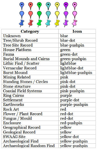
| SWAAG Database
Archaeology and Landscape Records Use the page navigation tools to move around the map and zooming in and out. The data can be set against a variety of backgrounds: Google Maps, Terrain View, Satellite Image and Google Earth. Click a marker to read short description. The View Record link will take you to the database record including photographs. |
|
View SWAAG Database - Archaeology Landscape Records in a larger map |
 |
| Home | Membership| Meetings | Projects | Publications | Database Records | Maps | Artwork | Trees | Geology | Links | Contact |
Copyright ©2009- swaag.org. All rights reserved.
Registered Charitable Incorporated Organisation (England & Wales)
Number 1155775 SWALEDALE AND
ARKENGARTHDALE ARCHAEOLOGICAL GROUP