| Viewing swaag.org website implies consent to set cookies on your computer. Full details | Swaledale and
Arkengarthdale Archaeology Group Registered Charitable Incorporated Organisation Number 1155775 |
SWAAG Honorary President:
Tim Laurie FSA |
For many years Tim Laurie has been investigating the archaeologically rich dales landscape, centered on Swaledale but also extending into the neighbouring dales of Wensleydale and Teesdale. Early work in the 1980's with Andrew Fleming on Swaledale Ancient Land Boundaries Project - Interim Reports lead Tim to recognise the importance of relic and ancient trees within the dales landscape, and the previously unrecognised presence of indicator species from the post glacial era, particularly within Swaledale. Tim's Swaledale Woodland Project is an on-going project, and whilst the project's data can be found in this database (© Tim Laurie) it will be published as reports both in Tim's publications and elsewhere. Contact Tim here.
The Swaledale Woodland Project data present within the SWAAG database
has been broken down into 3 Levels:
Level 1: Geographical areas (1
record describing each of the 6 areas found on the map and in the list box below).
Level 2: Individual Tree Sites Records
within each geographical area.
Level 3: Individual Tree Records
within a Tree Site Record.
There are:
173 Tree Site records and 38
Tree records. Current priority is being given to adding Tree
Site records.
Not all Tree Site Records are not large enough to contain
individual Tree Records.
Whilst these records are available to be viewed by
other SWAAG search options found
here, all
three 'Record Levels' can only be easily viewed by selecting one of the
6 study areas from the map below.
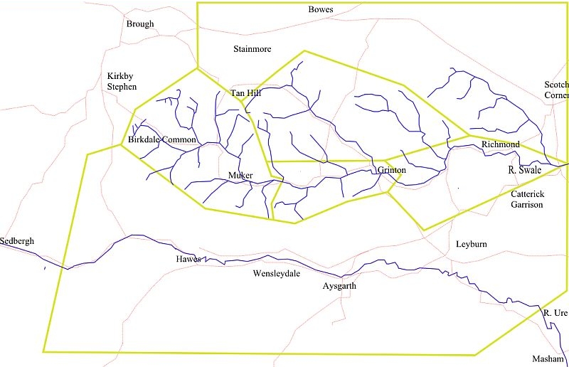
Click the map or the link beside the
record count:
| Lower Swaledale: 23 |
| Mid Swaledale: 17 |
| Stainmore: 16 |
| Swaledale North Bank Catchment: 42 |
| Upper Swaledale: 72 |
| Wensleydale: 17 |
| Database: Stephen Eastmead |